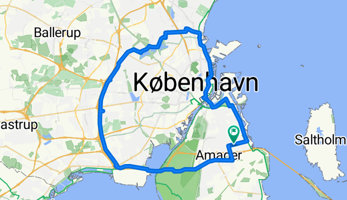
Vestvolden rundt
Un itinéraire vélo au départ de Tårnby, Hovedstaden, Danemark.
Vue d'ensemble
À propos du circuit
Le départ et l'arrivée se font à l'Airport Dan Hotel.
Majoritairement goudronné, mais pas à 100%. Comprend une grande partie du sentier très agréable le long des anciennes fortifications occidentales.
La piste cyclable dévie à droite de Vejlands Alee @ Center Blvd ; pas bien marquée --- vous n'êtes pas obligé d'utiliser la voie de bus ; la piste cyclable réelle est juste au nord ; séparée par des arbres ; plutôt agréable.
À l'est à éviter : la route Vestvolden fait traverser au cycliste la Gammel Koge Landevej, en tournant à droite, puis à gauche après avoir traversé le fossé.
Un apparent cul-de-sac dans une voie ferrée peut être rencontré si le GPS est réglé trop 'dehors' -- le passage est un souterrain à quelques centaines de mètres à l'est.
La 156 Roskildervej est traversée par un pont pour cyclistes/piétons ; la coupure du sentier est facile à manquer.
La traversée de E47 Jyllingevej se fait par un pont à vélos avec des marches et un seul canal pour les roues ; trop raide pour certains vélo-cargos (par exemple, Winther Kangaroo) pour passer ; gênant pour beaucoup de tricycles et de velomobiles ; une traversée dégagée (mais non protégée, incontrôlée et probablement illégale) peut être faite à moins de 100m à l'est.
Le sentier se termine au rail peu avant le 211 ; le retour est court si vous manquez le détour pour le passage supérieur à vélos (gg) L'étiquette est '> Utterslev Mose'.
Au total, il y avait un peu plus de 36 miles quand nous l'avons fait (quelques détours).
(cloned from route 338766)
- -:--
- Durée
- 51,3 km
- Distance
- 50 m
- Montée
- 50 m
- Descente
- ---
- Vit. moyenne
- ---
- Altitude max.
Qualité de l’itinéraire
Types de voies et surfaces le long de l’itinéraire
Types de routes
Piste cyclable
20,5 km
(40 %)
Route
16,9 km
(33 %)
surfaces
Pavé
49,7 km
(97 %)
Non pavé
1 km
(2 %)
Asphalte
49,7 km
(97 %)
Gravier
1 km
(2 %)
Indéfini
0,5 km
(1 %)
Continuer avec Bikemap
Utilise, modifie ou télécharge cet itinéraire vélo
Tu veux parcourir Vestvolden rundt ou l’adapter à ton propre voyage ? Voici ce que tu peux faire avec cet itinéraire Bikemap :
Fonctionnalités gratuites
- Enregistre cet itinéraire comme favori ou dans une collection
- Copie et planifie ta propre version de cet itinéraire
- Synchronise ton itinéraire avec Garmin ou Wahoo
Fonctionnalités Premium
Essai gratuit de 3 jours, ou paiement unique. En savoir plus sur Bikemap Premium.
- Navigue sur cet itinéraire sur iOS et Android
- Exporter un fichier GPX / KML de cet itinéraire
- Crée ton impression personnalisée (essaie-la gratuitement)
- Télécharge cet itinéraire pour la navigation hors ligne
Découvre plus de fonctionnalités Premium.
Obtiens Bikemap PremiumDe notre communauté
Tårnby : Autres itinéraires populaires qui commencent ici
 Round Amager 3
- Distance
- 39,8 km
- Montée
- 16 m
- Descente
- 17 m
- Emplacement
- Tårnby, Hovedstaden, Danemark
 AC Hotel to Helsingør
- Distance
- 50,7 km
- Montée
- 96 m
- Descente
- 95 m
- Emplacement
- Tårnby, Hovedstaden, Danemark
 Vestvolden rundt
- Distance
- 51,3 km
- Montée
- 50 m
- Descente
- 50 m
- Emplacement
- Tårnby, Hovedstaden, Danemark
 CPH HOTEL -> PLANESPOTTING
- Distance
- 8,7 km
- Montée
- 46 m
- Descente
- 32 m
- Emplacement
- Tårnby, Hovedstaden, Danemark
 Amager rundt
- Distance
- 50 km
- Montée
- 22 m
- Descente
- 19 m
- Emplacement
- Tårnby, Hovedstaden, Danemark
 Hvidovre turen
- Distance
- 22,9 km
- Montée
- 13 m
- Descente
- 14 m
- Emplacement
- Tårnby, Hovedstaden, Danemark
 Da Dæmningsvej, Copenaghen a Strandstien, Dragør
- Distance
- 19,3 km
- Montée
- 0 m
- Descente
- 3 m
- Emplacement
- Tårnby, Hovedstaden, Danemark
 Rundt om havnen
- Distance
- 23,5 km
- Montée
- 13 m
- Descente
- 13 m
- Emplacement
- Tårnby, Hovedstaden, Danemark
Ouvre-la dans l’app


