
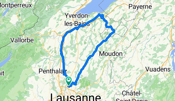
79 km: Romanel - Bottens - Thierrens - Combremont - Yvonand - Pomy - Ependes - Bavois - Romanel
Un itinéraire vélo au départ de Romanel, Canton of Vaud, Switzerland.
Vue d'ensemble
À propos du circuit
Romanel - Bottens - Thierrens - Combremont - Yvonand - Pomy - Ependes - Bavois - Romanel
- -:--
- Durée
- 79,5 km
- Distance
- 696 m
- Montée
- 696 m
- Descente
- ---
- Vit. moyenne
- ---
- Altitude max.

Qualité de l’itinéraire
Types de voies et surfaces le long de l’itinéraire
Types de routes
Route fréquentée
42,3 km
(53 %)
Route
30,6 km
(39 %)
surfaces
Pavé
36,2 km
(46 %)
Non pavé
0,1 km
(<1 %)
Asphalte
36,2 km
(46 %)
Béton
0,1 km
(<1 %)
Continuer avec Bikemap
Utilise, modifie ou télécharge cet itinéraire vélo
Tu veux parcourir 79 km: Romanel - Bottens - Thierrens - Combremont - Yvonand - Pomy - Ependes - Bavois - Romanel ou l’adapter à ton propre voyage ? Voici ce que tu peux faire avec cet itinéraire Bikemap :
Fonctionnalités gratuites
- Enregistre cet itinéraire comme favori ou dans une collection
- Copie et planifie ta propre version de cet itinéraire
- Synchronise ton itinéraire avec Garmin ou Wahoo
Fonctionnalités Premium
Essai gratuit de 3 jours, ou paiement unique. En savoir plus sur Bikemap Premium.
- Navigue sur cet itinéraire sur iOS et Android
- Exporter un fichier GPX / KML de cet itinéraire
- Crée ton impression personnalisée (essaie-la gratuitement)
- Télécharge cet itinéraire pour la navigation hors ligne
Découvre plus de fonctionnalités Premium.
Obtiens Bikemap PremiumDe notre communauté
Romanel : Autres itinéraires populaires qui commencent ici
 a 111 km: Grandvaux - Chardonne - Châtel - Vaulruz - Romont - Moudon
- Distance
- 114,6 km
- Montée
- 1 246 m
- Descente
- 1 247 m
- Emplacement
- Romanel, Canton of Vaud, Switzerland
 95 km: Col de Jaman
- Distance
- 96,9 km
- Montée
- 1 865 m
- Descente
- 1 865 m
- Emplacement
- Romanel, Canton of Vaud, Switzerland
 42km: Chavornay - Suchy - Penthéréaz - Etagnières
- Distance
- 42,7 km
- Montée
- 309 m
- Descente
- 306 m
- Emplacement
- Romanel, Canton of Vaud, Switzerland
 94 km: Romanel - Châtel-St-Denis - Moudon - Sottens - Vuarrens - Echallens - Bioley - Etagnières - Romanel
- Distance
- 94,6 km
- Montée
- 1 000 m
- Descente
- 1 000 m
- Emplacement
- Romanel, Canton of Vaud, Switzerland
 a 116 km: Petite Corniche - Châtel - Oron - Moudon - Sottens - Chappelle - Ursins -Ependes - Bavois - Taulard
- Distance
- 115,7 km
- Montée
- 1 156 m
- Descente
- 1 156 m
- Emplacement
- Romanel, Canton of Vaud, Switzerland
 a 108 km : Marchairuz - Mollendruz - La Sarraz
- Distance
- 108,3 km
- Montée
- 1 459 m
- Descente
- 1 460 m
- Emplacement
- Romanel, Canton of Vaud, Switzerland
 a135 km: Romanel - Mauborget - Val de Travers - Côte aux Féees - Aiguillon - Orbe - Romanel
- Distance
- 134 km
- Montée
- 1 800 m
- Descente
- 1 801 m
- Emplacement
- Romanel, Canton of Vaud, Switzerland
 79 km: Romanel - Bottens - Thierrens - Combremont - Yvonand - Pomy - Ependes - Bavois - Romanel
- Distance
- 79,5 km
- Montée
- 696 m
- Descente
- 696 m
- Emplacement
- Romanel, Canton of Vaud, Switzerland
Ouvre-la dans l’app