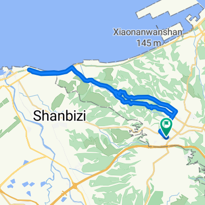
Linkou-林口 to Dayuan-大圓
Un itinéraire vélo au départ de Comté de Taoyuan, Taiwan, Taïwan.
Vue d'ensemble
À propos du circuit
C'est une belle balade typique sur la 106 avec ses jolies courbes allant vers la plage le long de la route 15. En direction de Dayuan, vous pouvez rouler à vitesse avec une légère montée. Puis tournez à la grande intersection via le passage souterrain et faites un peu plus de travail de vitesse sur le chemin du retour. La 106 dans la vallée offre un bon travail lent avec de très belles vues sur les fermes en prenant la route de retour par la vallée vers Linkou. Le kilomètre 27 à 28,5 est probablement l'un des ascensions les plus difficiles que j'ai rencontrées lors d'une sortie en groupe. Court et raide. Enfin un 'granny gear' pour moi...
- -:--
- Durée
- 32,2 km
- Distance
- 310 m
- Montée
- 310 m
- Descente
- ---
- Vit. moyenne
- ---
- Altitude max.
Continuer avec Bikemap
Utilise, modifie ou télécharge cet itinéraire vélo
Tu veux parcourir Linkou-林口 to Dayuan-大圓 ou l’adapter à ton propre voyage ? Voici ce que tu peux faire avec cet itinéraire Bikemap :
Fonctionnalités gratuites
- Enregistre cet itinéraire comme favori ou dans une collection
- Copie et planifie ta propre version de cet itinéraire
- Synchronise ton itinéraire avec Garmin ou Wahoo
Fonctionnalités Premium
Essai gratuit de 3 jours, ou paiement unique. En savoir plus sur Bikemap Premium.
- Navigue sur cet itinéraire sur iOS et Android
- Exporter un fichier GPX / KML de cet itinéraire
- Crée ton impression personnalisée (essaie-la gratuitement)
- Télécharge cet itinéraire pour la navigation hors ligne
Découvre plus de fonctionnalités Premium.
Obtiens Bikemap PremiumDe notre communauté
Comté de Taoyuan : Autres itinéraires populaires qui commencent ici
 100.03.12 鶯歌到三坑 <慢騎cloub>
- Distance
- 43,1 km
- Montée
- 224 m
- Descente
- 224 m
- Emplacement
- Comté de Taoyuan, Taiwan, Taïwan
 樹琳大棟山
樹琳大棟山- Distance
- 4,4 km
- Montée
- 369 m
- Descente
- 80 m
- Emplacement
- Comté de Taoyuan, Taiwan, Taïwan
 三峽 ------> 羅馬公路-------> 三峽
- Distance
- 97,2 km
- Montée
- 981 m
- Descente
- 980 m
- Emplacement
- Comté de Taoyuan, Taiwan, Taïwan
 羅馬公路自由行
- Distance
- 97,4 km
- Montée
- 0 m
- Descente
- 0 m
- Emplacement
- Comté de Taoyuan, Taiwan, Taïwan
 一日桃高圖
一日桃高圖- Distance
- 362,3 km
- Montée
- 155 m
- Descente
- 246 m
- Emplacement
- Comté de Taoyuan, Taiwan, Taïwan
 鶯歌到大溪
鶯歌到大溪- Distance
- 13,7 km
- Montée
- 160 m
- Descente
- 84 m
- Emplacement
- Comté de Taoyuan, Taiwan, Taïwan
 Linkou-林口 to Dayuan-大圓
- Distance
- 32,2 km
- Montée
- 310 m
- Descente
- 310 m
- Emplacement
- Comté de Taoyuan, Taiwan, Taïwan
 熊空茶園
熊空茶園- Distance
- 15,5 km
- Montée
- 805 m
- Descente
- 146 m
- Emplacement
- Comté de Taoyuan, Taiwan, Taïwan
Ouvre-la dans l’app


