

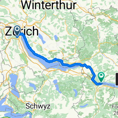
Zürich - Sihlbrugg - Stallikon - Zürich
Un itinéraire vélo au départ de Zürich (Kreis 3), Canton of Zurich, Switzerland.
Vue d'ensemble
À propos du circuit
Zürich - Sihlbrugg - Stallikon - Zürich
- -:--
- Durée
- 46,7 km
- Distance
- 384 m
- Montée
- 384 m
- Descente
- ---
- Vit. moyenne
- ---
- Altitude max.
Qualité de l’itinéraire
Types de voies et surfaces le long de l’itinéraire
Types de routes
Route fréquentée
33,3 km
(71 %)
Route
5,2 km
(11 %)
surfaces
Pavé
43,9 km
(94 %)
Non pavé
0,2 km
(<1 %)
Asphalte
43,9 km
(94 %)
Gravier
0,1 km
(<1 %)
Continuer avec Bikemap
Utilise, modifie ou télécharge cet itinéraire vélo
Tu veux parcourir Zürich - Sihlbrugg - Stallikon - Zürich ou l’adapter à ton propre voyage ? Voici ce que tu peux faire avec cet itinéraire Bikemap :
Fonctionnalités gratuites
- Enregistre cet itinéraire comme favori ou dans une collection
- Copie et planifie ta propre version de cet itinéraire
- Synchronise ton itinéraire avec Garmin ou Wahoo
Fonctionnalités Premium
Essai gratuit de 3 jours, ou paiement unique. En savoir plus sur Bikemap Premium.
- Navigue sur cet itinéraire sur iOS et Android
- Exporter un fichier GPX / KML de cet itinéraire
- Crée ton impression personnalisée (essaie-la gratuitement)
- Télécharge cet itinéraire pour la navigation hors ligne
Découvre plus de fonctionnalités Premium.
Obtiens Bikemap PremiumDe notre communauté
Zürich (Kreis 3) : Autres itinéraires populaires qui commencent ici
 Zürich - Sihlbrugg - Zug - Arth - Hausen a.A. - Stallikon - Zürich
- Distance
- 101,1 km
- Montée
- 735 m
- Descente
- 735 m
- Emplacement
- Zürich (Kreis 3), Canton of Zurich, Switzerland
 Gockhausen Binz
- Distance
- 19,9 km
- Montée
- 374 m
- Descente
- 155 m
- Emplacement
- Zürich (Kreis 3), Canton of Zurich, Switzerland
 Zürich (Kreis 1) - Näfels
- Distance
- 69,3 km
- Montée
- 440 m
- Descente
- 502 m
- Emplacement
- Zürich (Kreis 3), Canton of Zurich, Switzerland
 Zürich - Sihlbrugg - Zug - Steinerberg - Sihlbrugg - Zürich
- Distance
- 94,3 km
- Montée
- 604 m
- Descente
- 604 m
- Emplacement
- Zürich (Kreis 3), Canton of Zurich, Switzerland
 Zürich - Rapperswil - Schindellegi - Horgen - Zürich
- Distance
- 75,4 km
- Montée
- 427 m
- Descente
- 428 m
- Emplacement
- Zürich (Kreis 3), Canton of Zurich, Switzerland
 Zürich - Sihlbrugg - Affoltern - Birmensdorf - Zürich
- Distance
- 53,6 km
- Montée
- 443 m
- Descente
- 442 m
- Emplacement
- Zürich (Kreis 3), Canton of Zurich, Switzerland
 Zürich - Albis - Arth - Ibergeregg - Hütten - Buchenegg - Zürich
- Distance
- 142,1 km
- Montée
- 1 673 m
- Descente
- 1 674 m
- Emplacement
- Zürich (Kreis 3), Canton of Zurich, Switzerland
 Zürich - Sihlbrugg - Stallikon - Zürich
- Distance
- 46,7 km
- Montée
- 384 m
- Descente
- 384 m
- Emplacement
- Zürich (Kreis 3), Canton of Zurich, Switzerland
Ouvre-la dans l’app