

The Ladywell Way - Motherwell to Forth Road Bridge
Un itinéraire vélo au départ de Motherwell, Ecosse, Royaume-Uni.
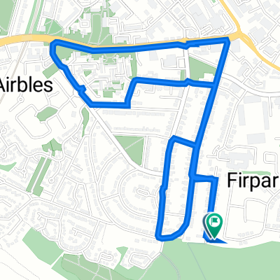
Vue d'ensemble
À propos du circuit
Great pilgrimage route from Motherwell to Forth Road Bridge and then on to St Andrews About 60 kilometres starting with quiet roads leading from Mothewell town centre and then out into the countryside onto bleak moorland paths, river tracks, and canals footpaths. Historic gems like William Wallace's cave, Abercorn church and Hopetoun House along the way. For detailed route descriptions see The Ladywell Way - Motherwell to Hillend The Ladywell Way - Hillend to Avonbridge The Ladywell Way – Avonbridge to Linlithgow The Ladywell Way - Linlithgow to Forth Road Bridge Part of The Way of St Andrews - For other routes see http://www.thewayofstandrews.com
- -:--
- Durée
- 57,1 km
- Distance
- 312 m
- Montée
- 371 m
- Descente
- ---
- Vit. moyenne
- ---
- Altitude max.

Points forts de l’itinéraire
Points d’intérêt le long de l’itinéraire

Point d'intérêt après 2,8 km
Carfin Grotto. This shrine, in emulation of the famous grotto at Lourdes, was started in the 1920s and built by local parishioners and coal miners out of work during the 1921 Coal Miners' Strike. The parish priest felt the need to keep these workers occupied to minimise the effects of unemployment on their morale.

Point d'intérêt après 27,7 km
Joins River Avon Heritage Trail
Point d'intérêt après 34,1 km
Leaves Avon Heritage Trail

Point d'intérêt après 40 km
Union Canal. This canal, running from Falkirk to Edinburgh, was constructed in the early nineteenth century to bring minerals, especially coal, to Edinburgh
Continuer avec Bikemap
Utilise, modifie ou télécharge cet itinéraire vélo
Tu veux parcourir The Ladywell Way - Motherwell to Forth Road Bridge ou l’adapter à ton propre voyage ? Voici ce que tu peux faire avec cet itinéraire Bikemap :
Fonctionnalités gratuites
- Enregistre cet itinéraire comme favori ou dans une collection
- Copie et planifie ta propre version de cet itinéraire
- Synchronise ton itinéraire avec Garmin ou Wahoo
Fonctionnalités Premium
Essai gratuit de 3 jours, ou paiement unique. En savoir plus sur Bikemap Premium.
- Navigue sur cet itinéraire sur iOS et Android
- Exporter un fichier GPX / KML de cet itinéraire
- Crée ton impression personnalisée (essaie-la gratuitement)
- Télécharge cet itinéraire pour la navigation hors ligne
Découvre plus de fonctionnalités Premium.
Obtiens Bikemap PremiumDe notre communauté
Motherwell : Autres itinéraires populaires qui commencent ici
 Woodlands Road 31 to Woodlands Road 29
- Distance
- 4,1 km
- Montée
- 34 m
- Descente
- 81 m
- Emplacement
- Motherwell, Ecosse, Royaume-Uni
 North-Holytown-The Craig- Strathy-Home
- Distance
- 21,2 km
- Montée
- 151 m
- Descente
- 151 m
- Emplacement
- Motherwell, Ecosse, Royaume-Uni
 The Ladywell Way - Motherwell to Hillend Reservoir
- Distance
- 33 km
- Montée
- 340 m
- Descente
- 339 m
- Emplacement
- Motherwell, Ecosse, Royaume-Uni
 The Ladywell Way - Motherwell to Hillend Reservoir
- Distance
- 17,3 km
- Montée
- 268 m
- Descente
- 147 m
- Emplacement
- Motherwell, Ecosse, Royaume-Uni
 Solo JOGLE Day 5
- Distance
- 123,1 km
- Montée
- 550 m
- Descente
- 525 m
- Emplacement
- Motherwell, Ecosse, Royaume-Uni
 Watling Street
- Distance
- 17,9 km
- Montée
- 151 m
- Descente
- 148 m
- Emplacement
- Motherwell, Ecosse, Royaume-Uni
 Home loop via barronshaugh
- Distance
- 10,9 km
- Montée
- 104 m
- Descente
- 103 m
- Emplacement
- Motherwell, Ecosse, Royaume-Uni
 Recovered Route
- Distance
- 11 km
- Montée
- 210 m
- Descente
- 223 m
- Emplacement
- Motherwell, Ecosse, Royaume-Uni
Ouvre-la dans l’app