1.Route des Grandes Alpes - Day One
Un itinéraire vélo au départ de Les Gets, Auvergne-Rhône-Alpes, France.
Vue d'ensemble
À propos du circuit
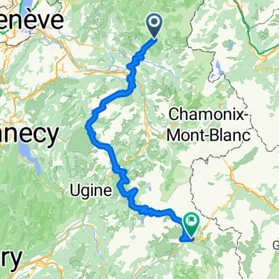
80 km, 2310 m de dénivelé, 2 cols. de catégorie 1. Le premier jour de cette tourné épique, nous avons 30 km pour échauffer nos jambes avant le grand premier ascension. Le Col de la Colombière, inclus 20 fois dans le Tour de France, est où cette tournée commence vraiment. Sauvage et inhabité, avec 16,3 km et un gain d'altitude de 1108 m, c'est une montée en deux parties avec une section plus douce au milieu. Une descente rapide vers Thônes et nous recommençons à grimper, à travers la station de ski de La Clusaz jusqu'au Col d'Aravis. Avec un gain de 630 m, le col est un point bas de la chaîne impressionnante de montagnes des Aravis. De là, nous nous dirigeons vers Crest Voland au pied de la montée du lendemain matin. Hébergement : Hôtel La Mollinière, 73590 Notre Dame de Bellecombe (Savoie • France), Tél. 04 79 31 61 51
- -:--
- Durée
- 74 km
- Distance
- 2 063 m
- Montée
- 2 090 m
- Descente
- ---
- Vit. moyenne
- ---
- Altitude max.
Qualité de l’itinéraire
Types de voies et surfaces le long de l’itinéraire
Types de routes
Route tranquille
1,5 km
(2 %)
Route d'accès
0,7 km
(1 %)
surfaces
Pavé
68,8 km
(93 %)
Asphalte
68,8 km
(93 %)
Indéfini
5,2 km
(7 %)
Continuer avec Bikemap
Utilise, modifie ou télécharge cet itinéraire vélo
Tu veux parcourir 1.Route des Grandes Alpes - Day One ou l’adapter à ton propre voyage ? Voici ce que tu peux faire avec cet itinéraire Bikemap :
Fonctionnalités gratuites
- Enregistre cet itinéraire comme favori ou dans une collection
- Copie et planifie ta propre version de cet itinéraire
- Synchronise ton itinéraire avec Garmin ou Wahoo
Fonctionnalités Premium
Essai gratuit de 3 jours, ou paiement unique. En savoir plus sur Bikemap Premium.
- Navigue sur cet itinéraire sur iOS et Android
- Exporter un fichier GPX / KML de cet itinéraire
- Crée ton impression personnalisée (essaie-la gratuitement)
- Télécharge cet itinéraire pour la navigation hors ligne
Découvre plus de fonctionnalités Premium.
Obtiens Bikemap PremiumDe notre communauté
Les Gets : Autres itinéraires populaires qui commencent ici
 6. Etappe: Les Gets - Col des Aravis
- Distance
- 65,8 km
- Montée
- 1 668 m
- Descente
- 1 605 m
- Emplacement
- Les Gets, Auvergne-Rhône-Alpes, France
 Col de l'encrenaz
- Distance
- 26,8 km
- Montée
- 763 m
- Descente
- 763 m
- Emplacement
- Les Gets, Auvergne-Rhône-Alpes, France
 Day 2
Day 2- Distance
- 158,9 km
- Montée
- 3 540 m
- Descente
- 3 279 m
- Emplacement
- Les Gets, Auvergne-Rhône-Alpes, France
 2017 Alps 1
- Distance
- 112,9 km
- Montée
- 2 874 m
- Descente
- 2 864 m
- Emplacement
- Les Gets, Auvergne-Rhône-Alpes, France
 Les Gets - Ramaz - Encrenaz
- Distance
- 56,3 km
- Montée
- 1 437 m
- Descente
- 1 434 m
- Emplacement
- Les Gets, Auvergne-Rhône-Alpes, France
 1.Route des Grandes Alpes - Day One
- Distance
- 74 km
- Montée
- 2 063 m
- Descente
- 2 090 m
- Emplacement
- Les Gets, Auvergne-Rhône-Alpes, France
 Les Gets - col d'Ecrenaz, les chavannes
- Distance
- 34,6 km
- Montée
- 1 051 m
- Descente
- 1 051 m
- Emplacement
- Les Gets, Auvergne-Rhône-Alpes, France
 2017 Alps 2
- Distance
- 151,8 km
- Montée
- 3 852 m
- Descente
- 4 052 m
- Emplacement
- Les Gets, Auvergne-Rhône-Alpes, France
Ouvre-la dans l’app


