

Doi Pui To Ban Pong
Un itinéraire vélo au départ de Chiang Mai, Chiang Mai, Thaïlande.
Vue d'ensemble
À propos du circuit
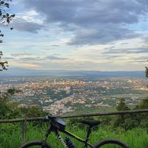
This is a fairly long cross country ride on the less travelled southern side of the Doi Suthep/Pui national park. It begins at Bhubing helipad on Sriwichai Rd., continues through Ban Hmong Doi Pui to the Doi Pha Klong viewpoint and then turns south running through forest, fields, orchards and bamboo groves until it reaches Samoeng Rd. (1269). It continues with an optional loop through the Krisdadoi hills before it returns to Samoeng Rd. From Ban Pong it takes a shortcut through the foothills directly to Ban Huai Sai and then the canal road.
The ride is 80% offroad over forest path, single track trails, fire roads and farm roads. The terrain is partly rough and requires a mountain bike. The total ascent is almost 700m and the total descent is 1700m.- -:--
- Durée
- 41,1 km
- Distance
- 576 m
- Montée
- 1 659 m
- Descente
- ---
- Vit. moyenne
- ---
- Altitude max.

Qualité de l’itinéraire
Types de voies et surfaces le long de l’itinéraire
Types de routes
Route forestière
18,2 km
(44 %)
Route tranquille
11,1 km
(27 %)
surfaces
Pavé
14,1 km
(34 %)
Non pavé
26,2 km
(64 %)
Non pavé (non défini)
21,7 km
(53 %)
Asphalte
8,8 km
(21 %)
Continuer avec Bikemap
Utilise, modifie ou télécharge cet itinéraire vélo
Tu veux parcourir Doi Pui To Ban Pong ou l’adapter à ton propre voyage ? Voici ce que tu peux faire avec cet itinéraire Bikemap :
Fonctionnalités gratuites
- Enregistre cet itinéraire comme favori ou dans une collection
- Copie et planifie ta propre version de cet itinéraire
- Synchronise ton itinéraire avec Garmin ou Wahoo
Fonctionnalités Premium
Essai gratuit de 3 jours, ou paiement unique. En savoir plus sur Bikemap Premium.
- Navigue sur cet itinéraire sur iOS et Android
- Exporter un fichier GPX / KML de cet itinéraire
- Crée ton impression personnalisée (essaie-la gratuitement)
- Télécharge cet itinéraire pour la navigation hors ligne
Découvre plus de fonctionnalités Premium.
Obtiens Bikemap PremiumDe notre communauté
Chiang Mai : Autres itinéraires populaires qui commencent ici
 Chiangmai U to Doi Su Thep view point
- Distance
- 18,1 km
- Montée
- 404 m
- Descente
- 403 m
- Emplacement
- Chiang Mai, Chiang Mai, Thaïlande
 Phuping Palace
- Distance
- 52,2 km
- Montée
- 1 083 m
- Descente
- 1 098 m
- Emplacement
- Chiang Mai, Chiang Mai, Thaïlande
 Cycle in Thai 03 : Chiang Rai, Myanmar
- Distance
- 263,6 km
- Montée
- 781 m
- Descente
- 703 m
- Emplacement
- Chiang Mai, Chiang Mai, Thaïlande
 DoiSuthep
- Distance
- 49,9 km
- Montée
- 1 107 m
- Descente
- 1 109 m
- Emplacement
- Chiang Mai, Chiang Mai, Thaïlande
 straight to samoeng
- Distance
- 41,2 km
- Montée
- 1 028 m
- Descente
- 849 m
- Emplacement
- Chiang Mai, Chiang Mai, Thaïlande
 CPB small circle
- Distance
- 13,7 km
- Montée
- 73 m
- Descente
- 71 m
- Emplacement
- Chiang Mai, Chiang Mai, Thaïlande
 Chiang Mai - Rim Ping
- Distance
- 65 km
- Montée
- 30 m
- Descente
- 29 m
- Emplacement
- Chiang Mai, Chiang Mai, Thaïlande
 Reverse Samoeng Loop back via Bhubbing Palace
- Distance
- 116,8 km
- Montée
- 2 847 m
- Descente
- 2 847 m
- Emplacement
- Chiang Mai, Chiang Mai, Thaïlande
Ouvre-la dans l’app