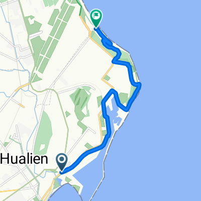
Actual DAY 09r: Hualien to Taidong, 168km
Un itinéraire vélo au départ de Hualien City, Taiwan, Taïwan.
Vue d'ensemble
À propos du circuit
Au lieu de l'itinéraire prévu, l'AMS a dû repenser la suite, mais au Grano House de Taichung, le patron m'a encouragé à prendre l'Express de Taichung jusqu'à Hualien puis faire du vélo de Hualien à Taidong.
J'ai donc fait emballer mon vélo au Grano House et j'ai reçu toute l'aide possible de M. Yu et de Zoe afin de pouvoir prendre un taxi tôt le matin pour arriver à la gare de Taichung et attraper l'Express de 5h56.
Tout s'est déroulé selon ce plan révisé et le voyage a été une véritable nouvelle expérience pour ce Singapourien de plus de 50 ans habitué aux plaines.
Ce fut la plus longue journée : pédaler de Hualien à Taidong, prendre l'Express de 20h pour Kaoshiung, chercher un hôtel (Kindess à 1700NT) et se reposer à 2h du matin après une lessive.
TRÈS SURPRENANT, je ne me suis pas vraiment senti épuisé après les 168 km. Je pense que l'impact complet de l'entraînement en altitude s'est fait sentir ici. Cela a été confirmé par M. Liu, un homme d'affaires en médecine traditionnelle chinoise assis à côté de moi, qui a dit que je ne paraissais pas du tout fatigué.
Révisé : je peux essayer de faire ces 240 km jusqu'à Checheng, prendre un taxi jusqu'à la gare de Zouying à Kaoshiung.
Reposer pour la nuit, visiter Velocite le lendemain et passer du temps à Kaoshiung avant de prendre le HSR pour retourner à Taipei.
On se rapproche... mais peut-être rester à Taitung pour un brunch, faire le plein avant de partir. Je considérerai de me reposer à Daren Township dans le comté de Taitung s'il y a des chambres d'hôtes.
- -:--
- Durée
- 168,3 km
- Distance
- 648 m
- Montée
- 619 m
- Descente
- ---
- Vit. moyenne
- ---
- Altitude max.
Qualité de l’itinéraire
Types de voies et surfaces le long de l’itinéraire
Types de routes
Route tranquille
15,1 km
(9 %)
Route d'accès
5 km
(3 %)
surfaces
Pavé
15,1 km
(9 %)
Asphalte
11,8 km
(7 %)
Pavé (non défini)
3,4 km
(2 %)
Indéfini
153,1 km
(91 %)
Points forts de l’itinéraire
Points d’intérêt le long de l’itinéraire
Point d'intérêt après 168,3 km
VELOCITE BIKE SHOP
Continuer avec Bikemap
Utilise, modifie ou télécharge cet itinéraire vélo
Tu veux parcourir Actual DAY 09r: Hualien to Taidong, 168km ou l’adapter à ton propre voyage ? Voici ce que tu peux faire avec cet itinéraire Bikemap :
Fonctionnalités gratuites
- Enregistre cet itinéraire comme favori ou dans une collection
- Copie et planifie ta propre version de cet itinéraire
- Divise-le en étapes pour créer un tour sur plusieurs jours
- Synchronise ton itinéraire avec Garmin ou Wahoo
Fonctionnalités Premium
Essai gratuit de 3 jours, ou paiement unique. En savoir plus sur Bikemap Premium.
- Navigue sur cet itinéraire sur iOS et Android
- Exporter un fichier GPX / KML de cet itinéraire
- Crée ton impression personnalisée (essaie-la gratuitement)
- Télécharge cet itinéraire pour la navigation hors ligne
Découvre plus de fonctionnalités Premium.
Obtiens Bikemap PremiumDe notre communauté
Hualien City : Autres itinéraires populaires qui commencent ici
 七星潭單車道
- Distance
- 9,7 km
- Montée
- 44 m
- Descente
- 49 m
- Emplacement
- Hualien City, Taiwan, Taïwan
 花蓮雙潭輕鬆騎
- Distance
- 91,8 km
- Montée
- 677 m
- Descente
- 679 m
- Emplacement
- Hualien City, Taiwan, Taïwan
 Luodong
- Distance
- 99,8 km
- Montée
- 1 728 m
- Descente
- 1 776 m
- Emplacement
- Hualien City, Taiwan, Taïwan
 NeverStop 300K (保存版)
- Distance
- 307,1 km
- Montée
- 989 m
- Descente
- 989 m
- Emplacement
- Hualien City, Taiwan, Taïwan
 樂虎LOVE 兩日東進武嶺(第一天)
- Distance
- 70,6 km
- Montée
- 4 065 m
- Descente
- 1 722 m
- Emplacement
- Hualien City, Taiwan, Taïwan
 花東三天兩夜
- Distance
- 194,7 km
- Montée
- 835 m
- Descente
- 800 m
- Emplacement
- Hualien City, Taiwan, Taïwan
 一日北高三日環島衝衝衝【花北段】
- Distance
- 186,2 km
- Montée
- 2 059 m
- Descente
- 2 087 m
- Emplacement
- Hualien City, Taiwan, Taïwan
 NeverStop 200K
- Distance
- 187,5 km
- Montée
- 775 m
- Descente
- 775 m
- Emplacement
- Hualien City, Taiwan, Taïwan
Ouvre-la dans l’app


