

K21/18 - Worfield-A454-B4176-Sutton Maddock-A442-Bridgnorth Circuit
Un itinéraire vélo au départ de Bridgnorth, Angleterre, Royaume-Uni.
Vue d'ensemble
À propos du circuit
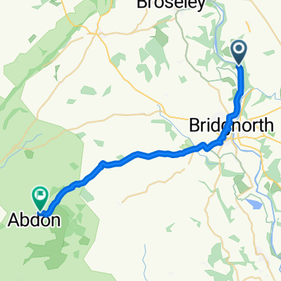
Commencer sur A454 en face de 'The Wheel' Inn au carrefour avec la route vers Worfield.\nRouler au nord-est le long de A454 jusqu'à la rotonde avec B4176 (Rudge Heath).\nPrendre la première sortie le long de B4176 vers la rotonde avec A442 à la station-service Sutton Maddock.\nPrendre la première sortie le long de A442 en direction de Bridgnorth jusqu'à la première rotonde.\nPrendre la première sortie en haut d'Hermitage Hill jusqu'à la rotonde avec A454.\nPrendre la 2ème sortie le long de A454 en direction de Wolverhampton jusqu'à finir à l'extrémité ouest de l'aire de repos 100m avant le départ.
- -:--
- Durée
- 29,1 km
- Distance
- 188 m
- Montée
- 187 m
- Descente
- ---
- Vit. moyenne
- ---
- Altitude max.
Continuer avec Bikemap
Utilise, modifie ou télécharge cet itinéraire vélo
Tu veux parcourir K21/18 - Worfield-A454-B4176-Sutton Maddock-A442-Bridgnorth Circuit ou l’adapter à ton propre voyage ? Voici ce que tu peux faire avec cet itinéraire Bikemap :
Fonctionnalités gratuites
- Enregistre cet itinéraire comme favori ou dans une collection
- Copie et planifie ta propre version de cet itinéraire
- Synchronise ton itinéraire avec Garmin ou Wahoo
Fonctionnalités Premium
Essai gratuit de 3 jours, ou paiement unique. En savoir plus sur Bikemap Premium.
- Navigue sur cet itinéraire sur iOS et Android
- Exporter un fichier GPX / KML de cet itinéraire
- Crée ton impression personnalisée (essaie-la gratuitement)
- Télécharge cet itinéraire pour la navigation hors ligne
Découvre plus de fonctionnalités Premium.
Obtiens Bikemap PremiumDe notre communauté
Bridgnorth : Autres itinéraires populaires qui commencent ici
 Severn Valley Cycle
- Distance
- 65,7 km
- Montée
- 503 m
- Descente
- 544 m
- Emplacement
- Bridgnorth, Angleterre, Royaume-Uni
 Richmond Gardens 9 to Shifnal Road
- Distance
- 23,4 km
- Montée
- 449 m
- Descente
- 366 m
- Emplacement
- Bridgnorth, Angleterre, Royaume-Uni
 B4373, Bridgnorth to Coalport Road, Telford
- Distance
- 12 km
- Montée
- 130 m
- Descente
- 165 m
- Emplacement
- Bridgnorth, Angleterre, Royaume-Uni
 Severn Valley Cycle Event 2016
- Distance
- 69 km
- Montée
- 538 m
- Descente
- 579 m
- Emplacement
- Bridgnorth, Angleterre, Royaume-Uni
 7 Stanmore Mews, Stourbridge Road, Bridgnorth nach B4194, Kinlet, Bewdley
- Distance
- 18,7 km
- Montée
- 285 m
- Descente
- 271 m
- Emplacement
- Bridgnorth, Angleterre, Royaume-Uni
 Day 4 Great Bolas (Wellington) to Hazel Grove
- Distance
- 148 km
- Montée
- 504 m
- Descente
- 627 m
- Emplacement
- Bridgnorth, Angleterre, Royaume-Uni
 Bridgnorth - Cardington
- Distance
- 22,1 km
- Montée
- 478 m
- Descente
- 223 m
- Emplacement
- Bridgnorth, Angleterre, Royaume-Uni
 JOGLE Day 8
- Distance
- 154 km
- Montée
- 494 m
- Descente
- 514 m
- Emplacement
- Bridgnorth, Angleterre, Royaume-Uni
Ouvre-la dans l’app