

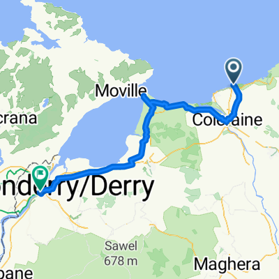
Portrush - Ballybogey - River Bann (35.32m/56.85km)
Un itinéraire vélo au départ de Portrush, Irlande du Nord, Royaume-Uni.
Vue d'ensemble
À propos du circuit
Our route heads South East from Portrush taking in the country lanes to the village of Ballyvogey. You then turn South West and continue your journey to the Eastern banks of the Lower River Bann where you turn Northwards and follow the road all the way to the University Town of Coleraine with the river never more than a few metres away from your left shoulder. This is a lovely and peaceful circuit which is relatively flat but long enough to justify a pint of the black stuff, a cake or both.
- -:--
- Durée
- 56,9 km
- Distance
- 211 m
- Montée
- 211 m
- Descente
- ---
- Vit. moyenne
- ---
- Altitude max.
Qualité de l’itinéraire
Types de voies et surfaces le long de l’itinéraire
Types de routes
Route
37,8 km
(66 %)
Route tranquille
11 km
(19 %)
surfaces
Pavé
48,7 km
(85 %)
Asphalte
48,7 km
(85 %)
Indéfini
8,3 km
(15 %)
Continuer avec Bikemap
Utilise, modifie ou télécharge cet itinéraire vélo
Tu veux parcourir Portrush - Ballybogey - River Bann (35.32m/56.85km) ou l’adapter à ton propre voyage ? Voici ce que tu peux faire avec cet itinéraire Bikemap :
Fonctionnalités gratuites
- Enregistre cet itinéraire comme favori ou dans une collection
- Copie et planifie ta propre version de cet itinéraire
- Synchronise ton itinéraire avec Garmin ou Wahoo
Fonctionnalités Premium
Essai gratuit de 3 jours, ou paiement unique. En savoir plus sur Bikemap Premium.
- Navigue sur cet itinéraire sur iOS et Android
- Exporter un fichier GPX / KML de cet itinéraire
- Crée ton impression personnalisée (essaie-la gratuitement)
- Télécharge cet itinéraire pour la navigation hors ligne
Découvre plus de fonctionnalités Premium.
Obtiens Bikemap PremiumDe notre communauté
Portrush : Autres itinéraires populaires qui commencent ici
 Day 15_ Portrush - Bushmills
- Distance
- 19,7 km
- Montée
- 248 m
- Descente
- 248 m
- Emplacement
- Portrush, Irlande du Nord, Royaume-Uni
 Relaxed route in Bushmills
- Distance
- 16,1 km
- Montée
- 116 m
- Descente
- 152 m
- Emplacement
- Portrush, Irlande du Nord, Royaume-Uni
 Portrush to Bushmills to Portrush
- Distance
- 20,4 km
- Montée
- 209 m
- Descente
- 208 m
- Emplacement
- Portrush, Irlande du Nord, Royaume-Uni
 Portrush - Magilligan Point (45.46m/73.17km)
- Distance
- 73,3 km
- Montée
- 508 m
- Descente
- 508 m
- Emplacement
- Portrush, Irlande du Nord, Royaume-Uni
 Strand Road 2 do Castlehill Way 8
- Distance
- 27,6 km
- Montée
- 133 m
- Descente
- 85 m
- Emplacement
- Portrush, Irlande du Nord, Royaume-Uni
 Portrush - Castlerock
- Distance
- 20,1 km
- Montée
- 151 m
- Descente
- 159 m
- Emplacement
- Portrush, Irlande du Nord, Royaume-Uni
 5 giorno
- Distance
- 74,8 km
- Montée
- 417 m
- Descente
- 423 m
- Emplacement
- Portrush, Irlande du Nord, Royaume-Uni
 Portrush - Portstewart Strand (8.7m/14km)
- Distance
- 14 km
- Montée
- 91 m
- Descente
- 93 m
- Emplacement
- Portrush, Irlande du Nord, Royaume-Uni
Ouvre-la dans l’app