

Cassis - Barjols
Un itinéraire vélo au départ de Cassis, Provence-Alpes-Côte d'Azur, France.
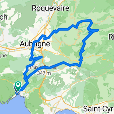
Vue d'ensemble
À propos du circuit
2.Etappe meiner Frankreich-Reise '08:
<table style="border-collapse: collapse; width: 98pt;" border="0" cellspacing="0" cellpadding="0" width="131"> <tbody> <tr style="height: 12.75pt;" height="17"> <td class="xl24" style="height: 12.75pt; width: 98pt;" width="131" height="17">
Cassis
</td> </tr> </tbody> </table>
<table style="border-collapse: collapse; width: 98pt;" border="0" cellspacing="0" cellpadding="0" width="131"> <tbody> <tr style="height: 12.75pt;" height="17"> <td class="xl25" style="height: 12.75pt;" height="17">
Mont de la Saoupe
</td> </tr> </tbody> </table> <table style="border-collapse: collapse; width: 98pt;" border="0" cellspacing="0" cellpadding="0" width="131"> <tbody> <tr style="height: 12.75pt;" height="17"> <td class="xl25" style="height: 12.75pt;" height="17">
Grde de Tête
</td> </tr> </tbody> </table> <table style="border-collapse: collapse; width: 98pt;" border="0" cellspacing="0" cellpadding="0" width="131"> <tbody> <tr style="height: 12.75pt;" height="17"> <td class="xl24" style="height: 12.75pt;" height="17">
La Ciotat
</td> </tr> </tbody> </table> <table style="border-collapse: collapse; width: 98pt;" border="0" cellspacing="0" cellpadding="0" width="131"> <tbody> <tr style="height: 12.75pt;" height="17"> <td class="xl24" style="height: 12.75pt;" height="17">
Ceyreste
</td> </tr> </tbody> </table> <table style="border-collapse: collapse; width: 98pt;" border="0" cellspacing="0" cellpadding="0" width="131"> <tbody> <tr style="height: 12.75pt;" height="17"> <td class="xl24" style="height: 12.75pt;" height="17">
Mauregard
</td> </tr> </tbody> </table> <table style="border-collapse: collapse; width: 98pt;" border="0" cellspacing="0" cellpadding="0" width="131"> <tbody> <tr style="height: 12.75pt;" height="17"> <td class="xl24" style="height: 12.75pt;" height="17">
Le Grd Caunet
</td> </tr> </tbody> </table> <table style="border-collapse: collapse; width: 98pt;" border="0" cellspacing="0" cellpadding="0" width="131"> <tbody> <tr style="height: 12.75pt;" height="17"> <td class="xl24" style="height: 12.75pt;" height="17">
Richtung Pinval / Gemenos
</td> </tr> </tbody> </table> <table style="border-collapse: collapse; width: 98pt;" border="0" cellspacing="0" cellpadding="0" width="131"> <tbody> <tr style="height: 12.75pt;" height="17"> <td class="xl24" style="height: 12.75pt;" height="17">
Gemenos
</td> </tr> </tbody> </table>
<table style="border-collapse: collapse; width: 98pt;" border="0" cellspacing="0" cellpadding="0" width="131"> <tbody> <tr style="height: 12.75pt;" height="17"> <td class="xl24" style="height: 12.75pt;" height="17"></td> </tr> </tbody> </table>
<table style="border-collapse: collapse; width: 98pt;" border="0" cellspacing="0" cellpadding="0" width="131"> <tbody> <tr style="height: 12.75pt;" height="17"> <td class="xl25" style="height: 12.75pt;" height="17">
Col d'Espigoulier
</td> </tr> </tbody> </table> <table style="border-collapse: collapse; width: 98pt;" border="0" cellspacing="0" cellpadding="0" width="131"> <tbody> <tr style="height: 12.75pt;" height="17"> <td class="xl24" style="height: 12.75pt;" height="17">
Plan-D'Aups
</td> </tr> </tbody> </table> <table style="border-collapse: collapse; width: 98pt;" border="0" cellspacing="0" cellpadding="0" width="131"> <tbody> <tr style="height: 12.75pt;" height="17"> <td class="xl24" style="height: 12.75pt;" height="17">
Mazaugues
</td> </tr> </tbody> </table> <table style="border-collapse: collapse; width: 98pt;" border="0" cellspacing="0" cellpadding="0" width="131"> <tbody> <tr style="height: 12.75pt;" height="17"> <td class="xl24" style="height: 12.75pt;" height="17"></td> </tr> </tbody> </table> <table style="border-collapse: collapse; width: 98pt;" border="0" cellspacing="0" cellpadding="0" width="131"> <tbody> <tr style="height: 12.75pt;" height="17"> <td class="xl24" style="height: 12.75pt;" height="17">
Les Censiés
</td> </tr> </tbody> </table> <table style="border-collapse: collapse; width: 98pt;" border="0" cellspacing="0" cellpadding="0" width="131"> <tbody> <tr style="height: 12.75pt;" height="17"> <td class="xl24" style="height: 12.75pt;" height="17">
Bras
</td> </tr> </tbody> </table> <table style="border-collapse: collapse; width: 98pt;" border="0" cellspacing="0" cellpadding="0" width="131"> <tbody> <tr style="height: 13.5pt;" height="18"> <td class="xl24" style="height: 13.5pt;" height="18">
Saint Estève
</td> </tr> </tbody> </table> <table style="border-collapse: collapse; width: 98pt;" border="0" cellspacing="0" cellpadding="0" width="131"> <tbody> <tr style="height: 12.75pt;" height="17"> <td class="xl24" style="height: 12.75pt;" height="17">
Brue Auriac
</td> </tr> </tbody> </table> <table style="border-collapse: collapse; width: 98pt;" border="0" cellspacing="0" cellpadding="0" width="131"> <tbody> <tr style="height: 12.75pt;" height="17"> <td class="xl24" style="height: 12.75pt;" height="17">
Barjols
</td> </tr> </tbody> </table>
<br />
<table style="border-collapse: collapse; width: 98pt;" border="0" cellspacing="0" cellpadding="0" width="131"> <tbody> </tbody> </table>
- -:--
- Durée
- 116,9 km
- Distance
- 1 705 m
- Montée
- 1 542 m
- Descente
- ---
- Vit. moyenne
- ---
- Altitude max.

Continuer avec Bikemap
Utilise, modifie ou télécharge cet itinéraire vélo
Tu veux parcourir Cassis - Barjols ou l’adapter à ton propre voyage ? Voici ce que tu peux faire avec cet itinéraire Bikemap :
Fonctionnalités gratuites
- Enregistre cet itinéraire comme favori ou dans une collection
- Copie et planifie ta propre version de cet itinéraire
- Divise-le en étapes pour créer un tour sur plusieurs jours
- Synchronise ton itinéraire avec Garmin ou Wahoo
Fonctionnalités Premium
Essai gratuit de 3 jours, ou paiement unique. En savoir plus sur Bikemap Premium.
- Navigue sur cet itinéraire sur iOS et Android
- Exporter un fichier GPX / KML de cet itinéraire
- Crée ton impression personnalisée (essaie-la gratuitement)
- Télécharge cet itinéraire pour la navigation hors ligne
Découvre plus de fonctionnalités Premium.
Obtiens Bikemap PremiumDe notre communauté
Cassis : Autres itinéraires populaires qui commencent ici
 La Ciotat-callanques_cassis
- Distance
- 30,6 km
- Montée
- 879 m
- Descente
- 880 m
- Emplacement
- Cassis, Provence-Alpes-Côte d'Azur, France
 callanques_cassis
- Distance
- 30,6 km
- Montée
- 916 m
- Descente
- 915 m
- Emplacement
- Cassis, Provence-Alpes-Côte d'Azur, France
 ride from Cassis to Marseille
- Distance
- 21,4 km
- Montée
- 249 m
- Descente
- 395 m
- Emplacement
- Cassis, Provence-Alpes-Côte d'Azur, France
 Provence 2009 - Tappa 07 (proposta)
- Distance
- 91,7 km
- Montée
- 929 m
- Descente
- 931 m
- Emplacement
- Cassis, Provence-Alpes-Côte d'Azur, France
 Cassis - Pic de Bertagne - Cassis
- Distance
- 64,6 km
- Montée
- 2 181 m
- Descente
- 2 171 m
- Emplacement
- Cassis, Provence-Alpes-Côte d'Azur, France
 calanque d’en vau
- Distance
- 16 km
- Montée
- 332 m
- Descente
- 326 m
- Emplacement
- Cassis, Provence-Alpes-Côte d'Azur, France
 Barcelona 11
- Distance
- 66 km
- Montée
- 750 m
- Descente
- 737 m
- Emplacement
- Cassis, Provence-Alpes-Côte d'Azur, France
 2016J20Soir : Casino de Cassis
- Distance
- 1,7 km
- Montée
- 9 m
- Descente
- 85 m
- Emplacement
- Cassis, Provence-Alpes-Côte d'Azur, France
Ouvre-la dans l’app