

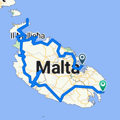
malta1
Un itinéraire vélo au départ de Valletta, Il-Belt Valletta, Malta.
Vue d'ensemble
À propos du circuit
malta1
- -:--
- Durée
- 91,7 km
- Distance
- 798 m
- Montée
- 805 m
- Descente
- ---
- Vit. moyenne
- ---
- Altitude max.
Points forts de l’itinéraire
Points d’intérêt le long de l’itinéraire
Point d'intérêt après 13,5 km
MArsakala + St Thomas Bay
Point d'intérêt après 19,7 km
Fishing harbour Sunday
Point d'intérêt après 34,4 km
Hagar Qim neolithic temple
Point d'intérêt après 35,2 km
Mnajdra Neolothic temple
Point d'intérêt après 40,5 km
Calapham junction deep ruts in the bedrock appear to have been formed in the remote past by wagons or carts. Some of these ruts cross rock-cut punic tombs, proving that the ruts existed before the tombs. In the vicinity there are large caves which used to be inhabited by troglodites.
Point d'intérêt après 44,6 km
Rabat
Point d'intérêt après 44,6 km
Mdina
Point d'intérêt après 52 km
Golden Bay + natural park
Point d'intérêt après 69,6 km
Il Mellieha
Point d'intérêt après 77,4 km
Mosta Dome
Continuer avec Bikemap
Utilise, modifie ou télécharge cet itinéraire vélo
Tu veux parcourir malta1 ou l’adapter à ton propre voyage ? Voici ce que tu peux faire avec cet itinéraire Bikemap :
Fonctionnalités gratuites
- Enregistre cet itinéraire comme favori ou dans une collection
- Copie et planifie ta propre version de cet itinéraire
- Divise-le en étapes pour créer un tour sur plusieurs jours
- Synchronise ton itinéraire avec Garmin ou Wahoo
Fonctionnalités Premium
Essai gratuit de 3 jours, ou paiement unique. En savoir plus sur Bikemap Premium.
- Navigue sur cet itinéraire sur iOS et Android
- Exporter un fichier GPX / KML de cet itinéraire
- Crée ton impression personnalisée (essaie-la gratuitement)
- Télécharge cet itinéraire pour la navigation hors ligne
Découvre plus de fonctionnalités Premium.
Obtiens Bikemap PremiumDe notre communauté
Valletta : Autres itinéraires populaires qui commencent ici
 Recovered Route
- Distance
- 200,9 km
- Montée
- 0 m
- Descente
- 15 m
- Emplacement
- Valletta, Il-Belt Valletta, Malta
 2 hour marsaxlott
- Distance
- 26,4 km
- Montée
- 343 m
- Descente
- 365 m
- Emplacement
- Valletta, Il-Belt Valletta, Malta
 Steady ride in
- Distance
- 14,2 km
- Montée
- 271 m
- Descente
- 285 m
- Emplacement
- Valletta, Il-Belt Valletta, Malta
 Around Malta
- Distance
- 103,9 km
- Montée
- 859 m
- Descente
- 903 m
- Emplacement
- Valletta, Il-Belt Valletta, Malta
 VALETTA MALTA CLASSICA
- Distance
- 135,6 km
- Montée
- 771 m
- Descente
- 774 m
- Emplacement
- Valletta, Il-Belt Valletta, Malta
 malta1
- Distance
- 91,7 km
- Montée
- 798 m
- Descente
- 805 m
- Emplacement
- Valletta, Il-Belt Valletta, Malta
 Waterfront til birgu
- Distance
- 8,2 km
- Montée
- 145 m
- Descente
- 156 m
- Emplacement
- Valletta, Il-Belt Valletta, Malta
 No Limit 32
- Distance
- 162 km
- Montée
- 270 m
- Descente
- 303 m
- Emplacement
- Valletta, Il-Belt Valletta, Malta
Ouvre-la dans l’app