

CALA JONDAL
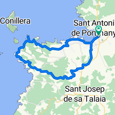
Un itinéraire vélo au départ de Sant Antoni de Portmany, Balearic Islands, Spain.
Vue d'ensemble
À propos du circuit
<div> This route is designed for lovers of countryside and mountain. It is a tour</div> <div> that requires us to have a good level of cycling proficiency and proven</div> <div> physical fitness. That said, we enjoy a journey that shows us the interior</div> <div> of the island's far southwest, introducing us to traditional crops,</div> <div> impressive views and winding lanes while we pass through woods and</div> <div> fields which, especially in spring, overflow with colour and Mediterranean</div> <div> essence.</div> <div> We begin by pedalling along asphalt but immediately exit from the paved</div> <div> route and immerse ourselves in a network of paths, tracks and trails that</div> <div> we do not leave until we have almost finished.</div> <div> During the almost 40-kilometres route we experience an approximate</div> <div> 900 metres' difference in altitude which we tackle at two accessible</div> <div> climbs, first, Capelleta, and second, Sa Talaia, although we do not arrive</div> <div> at their summits.</div> <div> Halfway through the journey -if the weather is right- it is almost</div> <div> impossible not to make the most of the brilliant waters of Cala Jondal or</div> <div> Porroig and take a refreshing dip. Afterwards, we climb halfway up the</div> <div> mountain of Sa Talaia, crossing impressive valleys full of local flora and</div> <div> fauna, and return to Sant Antoni through small, pretty fields of crops in</div> <div> more relaxing terrain.</div>
- -:--
- Durée
- 38 km
- Distance
- 651 m
- Montée
- 654 m
- Descente
- ---
- Vit. moyenne
- ---
- Altitude max.
Continuer avec Bikemap
Utilise, modifie ou télécharge cet itinéraire vélo
Tu veux parcourir CALA JONDAL ou l’adapter à ton propre voyage ? Voici ce que tu peux faire avec cet itinéraire Bikemap :
Fonctionnalités gratuites
- Enregistre cet itinéraire comme favori ou dans une collection
- Copie et planifie ta propre version de cet itinéraire
- Synchronise ton itinéraire avec Garmin ou Wahoo
Fonctionnalités Premium
Essai gratuit de 3 jours, ou paiement unique. En savoir plus sur Bikemap Premium.
- Navigue sur cet itinéraire sur iOS et Android
- Exporter un fichier GPX / KML de cet itinéraire
- Crée ton impression personnalisée (essaie-la gratuitement)
- Télécharge cet itinéraire pour la navigation hors ligne
Découvre plus de fonctionnalités Premium.
Obtiens Bikemap PremiumDe notre communauté
Sant Antoni de Portmany : Autres itinéraires populaires qui commencent ici
 Ibiza. Vuelta cicloturista. Etapa 3 (84km)
- Distance
- 84,5 km
- Montée
- 640 m
- Descente
- 643 m
- Emplacement
- Sant Antoni de Portmany, Balearic Islands, Spain
 Cala de Bou - Corona - Buscastell . Cala de Bou
- Distance
- 29,6 km
- Montée
- 326 m
- Descente
- 327 m
- Emplacement
- Sant Antoni de Portmany, Balearic Islands, Spain
 X vuelta cicloturismo Ibiza - 1ª etapa
- Distance
- 77,3 km
- Montée
- 528 m
- Descente
- 534 m
- Emplacement
- Sant Antoni de Portmany, Balearic Islands, Spain
 Trasa nr 8
- Distance
- 26,7 km
- Montée
- 357 m
- Descente
- 358 m
- Emplacement
- Sant Antoni de Portmany, Balearic Islands, Spain
 X Vuelta Cicloturismo Ibiza - 2ª etapa
- Distance
- 101,5 km
- Montée
- 982 m
- Descente
- 977 m
- Emplacement
- Sant Antoni de Portmany, Balearic Islands, Spain
 Lunarseed Loop - West Side I
- Distance
- 24,1 km
- Montée
- 498 m
- Descente
- 495 m
- Emplacement
- Sant Antoni de Portmany, Balearic Islands, Spain
 CALA JONDAL
- Distance
- 38 km
- Montée
- 651 m
- Descente
- 654 m
- Emplacement
- Sant Antoni de Portmany, Balearic Islands, Spain
 Moderate route in Sant Josep de Sa Talaia
- Distance
- 14 km
- Montée
- 962 m
- Descente
- 870 m
- Emplacement
- Sant Antoni de Portmany, Balearic Islands, Spain
Ouvre-la dans l’app