

CYCLING THE RHINE: Route 15A
Un itinéraire vélo au départ de Gernsheim, Hesse, Allemagne.
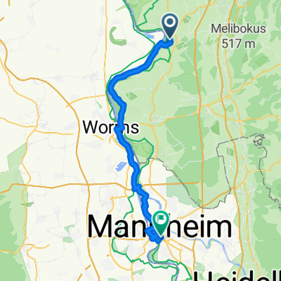
Vue d'ensemble
À propos du circuit
De la gare de Gernsheim à la gare de Mannheim, en suivant le Rhin.
- -:--
- Durée
- 48,9 km
- Distance
- 95 m
- Montée
- 85 m
- Descente
- ---
- Vit. moyenne
- ---
- Altitude max.

Qualité de l’itinéraire
Types de voies et surfaces le long de l’itinéraire
Types de routes
Route forestière
20,5 km
(42 %)
Sentier
8,3 km
(17 %)
surfaces
Pavé
30,8 km
(63 %)
Non pavé
9,3 km
(19 %)
Asphalte
23 km
(47 %)
Béton
6,8 km
(14 %)
Points forts de l’itinéraire
Points d’intérêt le long de l’itinéraire
Point d'intérêt après 1,5 km
If you prefer, follow this road as it curves left, then right to the Rhine. Turn left at the riverside, along the cyclepath.
Point d'intérêt après 2,1 km
At this point, the previous described route (Route 14A) deviated from the Rhine Route to terminate at Gernsheim railway station. To continue along the Rhine-side route, continue with the Rhine on your right hand side and join Route 15A at the next marked point on this map.
Point d'intérêt après 2,3 km
Rejoin the Rhine Route at this point, from Route 14A.
Hébergement après 21,1 km
Camp Site: I have used this campsite in the past and found the facilities to be excellent. Even after it had been recently flooded, I found a suitable place to camp.
Hébergement après 22,4 km
YOUTH HOSTEL: DJH Worms Dechaneigasse 1 67547 Worms I have stayed at this hostel and can recommend both the facilities and the cuisine.
Hébergement après 22,7 km
Friends of Nature Hostel, Worms
Point d'intérêt après 32,5 km
Bridge support (tower), with steps on the inside.
Point d'intérêt après 33,4 km
Bridge support (tower) with steps down on the inside.
Point d'intérêt après 37,4 km
Alternative route, when Sandhofer ferry is not operating, joins here.
Point d'intérêt après 44,9 km
At this point, instead of turning Left, you can carry straight onwards, swinging left to take the bi-directional cycle path along the left hand side of the bridge. When you reach the other side, take the bike offramp, then follow the signs to Jugendherberge (Youth Hostel), until you join the described route along the bike paths or near the Rhine.
Point d'intérêt après 46,9 km
Rejoin the described Route here, if you took the LHS bike path across the bridge.
Hébergement après 47,3 km
YOUTH HOSTEL: DJH Mannheim Rheinpromenade 21 68163 Mannheim
Point d'intérêt après 47,9 km
At this point, the route deviates from the Rhine Route, to terminate at Mannheim railway station. Continue along the riverside track (right fork) to continue along the Rhine Route.
Continuer avec Bikemap
Utilise, modifie ou télécharge cet itinéraire vélo
Tu veux parcourir CYCLING THE RHINE: Route 15A ou l’adapter à ton propre voyage ? Voici ce que tu peux faire avec cet itinéraire Bikemap :
Fonctionnalités gratuites
- Enregistre cet itinéraire comme favori ou dans une collection
- Copie et planifie ta propre version de cet itinéraire
- Synchronise ton itinéraire avec Garmin ou Wahoo
Fonctionnalités Premium
Essai gratuit de 3 jours, ou paiement unique. En savoir plus sur Bikemap Premium.
- Navigue sur cet itinéraire sur iOS et Android
- Exporter un fichier GPX / KML de cet itinéraire
- Crée ton impression personnalisée (essaie-la gratuitement)
- Télécharge cet itinéraire pour la navigation hors ligne
Découvre plus de fonctionnalités Premium.
Obtiens Bikemap PremiumDe notre communauté
Gernsheim : Autres itinéraires populaires qui commencent ici
 Wilhelm-Leuschner-Straße 3, Gernsheim nach Wilhelm-Leuschner-Straße 3, Gernsheim
- Distance
- 16,2 km
- Montée
- 3 m
- Descente
- 0 m
- Emplacement
- Gernsheim, Hesse, Allemagne
 Gernsheim - Kühkopf
- Distance
- 23,5 km
- Montée
- 57 m
- Descente
- 51 m
- Emplacement
- Gernsheim, Hesse, Allemagne
 Rhein-Radweg
- Distance
- 29,8 km
- Montée
- 61 m
- Descente
- 61 m
- Emplacement
- Gernsheim, Hesse, Allemagne
 CYCLING THE RHINE: Route 15A
- Distance
- 48,8 km
- Montée
- 89 m
- Descente
- 79 m
- Emplacement
- Gernsheim, Hesse, Allemagne
 Kühkopfrunde 2019
- Distance
- 59,9 km
- Montée
- 67 m
- Descente
- 65 m
- Emplacement
- Gernsheim, Hesse, Allemagne
 CYCLING THE RHINE: Route 15A
- Distance
- 48,9 km
- Montée
- 95 m
- Descente
- 85 m
- Emplacement
- Gernsheim, Hesse, Allemagne
 1990_Rheinhessen (Glan-Nahe-Rhein)_(Gernsheim - Worms - Alzey - Nieder-Olm - Ingelheim - Mainz - Gernsheim)
- Distance
- 191,4 km
- Montée
- 317 m
- Descente
- 320 m
- Emplacement
- Gernsheim, Hesse, Allemagne
 Vatertagsrunde
- Distance
- 40,9 km
- Montée
- 145 m
- Descente
- 144 m
- Emplacement
- Gernsheim, Hesse, Allemagne
Ouvre-la dans l’app