

Tissington and High Peak Trails (and the roady thing to join up the ends)
Un itinéraire vélo au départ de Ashbourne, Angleterre, Royaume-Uni.
Vue d'ensemble
À propos du circuit
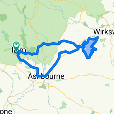
Départ d'Ashbourne, en montant sur le sentier Tissington qui présente une pente très légère, assez agaçante pendant les cinq premiers miles environ. Ensuite, ça s'adoucit et le reste est parfaitement plat, avec de nombreuses petites aires de repos, y compris Hartington Signal Box. Jusqu'à Parsley Hay, faites un demi-tour à 180° et redescendez par le High Peak Trail, qui est tout aussi plat avec une bonne surface. Deux pentes près de la fin de Cromford, toutes deux en faveur du cycliste dans ce sens ! Près de la fin de la deuxième pente, je sors du sentier sur la droite et rejoins les routes pour le dernier tronçon vers Ashbourne - beaucoup plus vallonné (quelques belles descentes) et les conducteurs sont des idiots. Quelques pubs si ça vous tente....
- -:--
- Durée
- 55,6 km
- Distance
- 437 m
- Montée
- 437 m
- Descente
- ---
- Vit. moyenne
- ---
- Altitude max.

Qualité de l’itinéraire
Types de voies et surfaces le long de l’itinéraire
Types de routes
Piste cyclable
40,6 km
(73 %)
Sentier
1,1 km
(2 %)
surfaces
Pavé
5,6 km
(10 %)
Non pavé
40 km
(72 %)
Gravier
40 km
(72 %)
Asphalte
5,6 km
(10 %)
Indéfini
10 km
(18 %)
Continuer avec Bikemap
Utilise, modifie ou télécharge cet itinéraire vélo
Tu veux parcourir Tissington and High Peak Trails (and the roady thing to join up the ends) ou l’adapter à ton propre voyage ? Voici ce que tu peux faire avec cet itinéraire Bikemap :
Fonctionnalités gratuites
- Enregistre cet itinéraire comme favori ou dans une collection
- Copie et planifie ta propre version de cet itinéraire
- Synchronise ton itinéraire avec Garmin ou Wahoo
Fonctionnalités Premium
Essai gratuit de 3 jours, ou paiement unique. En savoir plus sur Bikemap Premium.
- Navigue sur cet itinéraire sur iOS et Android
- Exporter un fichier GPX / KML de cet itinéraire
- Crée ton impression personnalisée (essaie-la gratuitement)
- Télécharge cet itinéraire pour la navigation hors ligne
Découvre plus de fonctionnalités Premium.
Obtiens Bikemap PremiumDe notre communauté
Ashbourne : Autres itinéraires populaires qui commencent ici
 Ashbourne - Alstonefield loop
- Distance
- 26,1 km
- Montée
- 486 m
- Descente
- 485 m
- Emplacement
- Ashbourne, Angleterre, Royaume-Uni
 Tissington and High Peak Trails (and the roady thing to join up the ends)
- Distance
- 55,6 km
- Montée
- 437 m
- Descente
- 437 m
- Emplacement
- Ashbourne, Angleterre, Royaume-Uni
 Route 10 Carsington Water circular
- Distance
- 43,6 km
- Montée
- 513 m
- Descente
- 514 m
- Emplacement
- Ashbourne, Angleterre, Royaume-Uni
 09.2018 Cov-M'cr-Cov. Dzien 2/3
- Distance
- 59,4 km
- Montée
- 491 m
- Descente
- 783 m
- Emplacement
- Ashbourne, Angleterre, Royaume-Uni
 ride in the peak district
- Distance
- 50,1 km
- Montée
- 723 m
- Descente
- 723 m
- Emplacement
- Ashbourne, Angleterre, Royaume-Uni
 Flashy Manifold Trail
- Distance
- 77,5 km
- Montée
- 1 186 m
- Descente
- 1 187 m
- Emplacement
- Ashbourne, Angleterre, Royaume-Uni
 tissington trail to high peak trail
- Distance
- 12,9 km
- Montée
- 219 m
- Descente
- 159 m
- Emplacement
- Ashbourne, Angleterre, Royaume-Uni
 C38.5 WPC
- Distance
- 62,3 km
- Montée
- 355 m
- Descente
- 357 m
- Emplacement
- Ashbourne, Angleterre, Royaume-Uni
Ouvre-la dans l’app