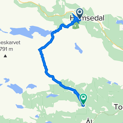
Fanitullvegen
Un itinéraire vélo au départ de Hemsedal, Buskerud, Norvège.
Vue d'ensemble
À propos du circuit
Beau sentier sur des routes de gravier dans les hautes montagnes sous Reineskarvet. Commencez depuis le Hemsedal Skisenter et suivez la route de Holdeskar (route à péage) ou utilisez le téléphérique. La route de gravier se termine à Leveld ou Vats. De là, vous pouvez suivre le Stølsruta plus loin vers Ål/Hol et Geilo. Nous recommandons également les pistes cyclables dans la région de Bergsjø.
- -:--
- Durée
- 31,5 km
- Distance
- 916 m
- Montée
- 866 m
- Descente
- ---
- Vit. moyenne
- ---
- Altitude max.
Qualité de l’itinéraire
Types de voies et surfaces le long de l’itinéraire
Types de routes
Route tranquille
26,8 km
(85 %)
Route
3,5 km
(11 %)
surfaces
Pavé
2,5 km
(8 %)
Non pavé
25,5 km
(81 %)
Gravier
25,5 km
(81 %)
Asphalte
2,5 km
(8 %)
Indéfini
3,5 km
(11 %)
Continuer avec Bikemap
Utilise, modifie ou télécharge cet itinéraire vélo
Tu veux parcourir Fanitullvegen ou l’adapter à ton propre voyage ? Voici ce que tu peux faire avec cet itinéraire Bikemap :
Fonctionnalités gratuites
- Enregistre cet itinéraire comme favori ou dans une collection
- Copie et planifie ta propre version de cet itinéraire
- Synchronise ton itinéraire avec Garmin ou Wahoo
Fonctionnalités Premium
Essai gratuit de 3 jours, ou paiement unique. En savoir plus sur Bikemap Premium.
- Navigue sur cet itinéraire sur iOS et Android
- Exporter un fichier GPX / KML de cet itinéraire
- Crée ton impression personnalisée (essaie-la gratuitement)
- Télécharge cet itinéraire pour la navigation hors ligne
Découvre plus de fonctionnalités Premium.
Obtiens Bikemap PremiumDe notre communauté
Hemsedal : Autres itinéraires populaires qui commencent ici
 Hemsedal
- Distance
- 52,6 km
- Montée
- 1 042 m
- Descente
- 1 042 m
- Emplacement
- Hemsedal, Buskerud, Norvège
 Kongevegen
- Distance
- 18,4 km
- Montée
- 1 526 m
- Descente
- 1 352 m
- Emplacement
- Hemsedal, Buskerud, Norvège
 Hemsedalsvegen 3533, Hemsedal do Hemsedalsvegen 3536, Hemsedal
- Distance
- 27,9 km
- Montée
- 1 206 m
- Descente
- 1 204 m
- Emplacement
- Hemsedal, Buskerud, Norvège
 Hemsedal (Holdeskaret)-Vats-Geilo
- Distance
- 70,9 km
- Montée
- 1 071 m
- Descente
- 1 377 m
- Emplacement
- Hemsedal, Buskerud, Norvège
 Dalløypa
- Distance
- 11,6 km
- Montée
- 511 m
- Descente
- 511 m
- Emplacement
- Hemsedal, Buskerud, Norvège
 Hemsedal Totten
- Distance
- 24,8 km
- Montée
- 0 m
- Descente
- 0 m
- Emplacement
- Hemsedal, Buskerud, Norvège
 Fanitullvegen
- Distance
- 31,5 km
- Montée
- 916 m
- Descente
- 866 m
- Emplacement
- Hemsedal, Buskerud, Norvège
 Hemsedal - Ål
- Distance
- 37 km
- Montée
- 686 m
- Descente
- 832 m
- Emplacement
- Hemsedal, Buskerud, Norvège
Ouvre-la dans l’app

