

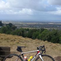
Scenic not too hilly cotswold bike ride
Un itinéraire vélo au départ de Cheltenham, Angleterre, Royaume-Uni.
Vue d'ensemble
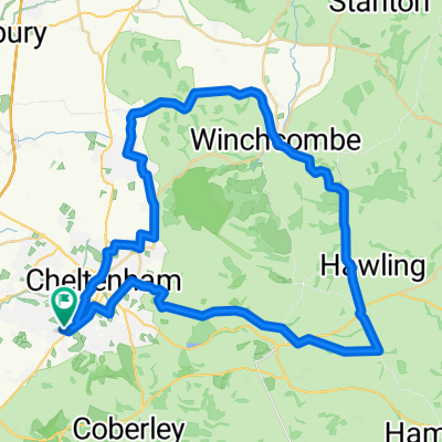
À propos du circuit
Au début, vous avez la montée de Leckhampton Hill à gravir, sur l'une de vos rares routes principales, jusqu'à la bifurcation à gauche pour le golf Cotwold Hill. Continuez tout droit en traversant la A436 en direction de Cowley, puis montez jusqu'à la A435 et traversez vers Upper Coberley. Suivez la route de campagne et, au bas de la colline, au carrefour, tournez à gauche en direction du point de vue de Kilkenny. À la route principale A436, tournez à droite sur la route principale, puis peu après, tournez à gauche au pub Kilkenny. Continuez tout droit au carrefour jusqu'à la A40. Tournez à droite, puis peu après à gauche vers Whittington. Tournez à gauche au carrefour en T et continuez le long de Ham Road en descente jusqu'à tourner à droite dans Mill Lane, puis dans Harp Hill. Traversez le domaine privé de Battledown jusqu'à Battledown Approach et continuez vers Hales Road jusqu'à la fin.
- -:--
- Durée
- 26,6 km
- Distance
- 443 m
- Montée
- 442 m
- Descente
- ---
- Vit. moyenne
- ---
- Altitude max.

Continuer avec Bikemap
Utilise, modifie ou télécharge cet itinéraire vélo
Tu veux parcourir Scenic not too hilly cotswold bike ride ou l’adapter à ton propre voyage ? Voici ce que tu peux faire avec cet itinéraire Bikemap :
Fonctionnalités gratuites
- Enregistre cet itinéraire comme favori ou dans une collection
- Copie et planifie ta propre version de cet itinéraire
- Synchronise ton itinéraire avec Garmin ou Wahoo
Fonctionnalités Premium
Essai gratuit de 3 jours, ou paiement unique. En savoir plus sur Bikemap Premium.
- Navigue sur cet itinéraire sur iOS et Android
- Exporter un fichier GPX / KML de cet itinéraire
- Crée ton impression personnalisée (essaie-la gratuitement)
- Télécharge cet itinéraire pour la navigation hors ligne
Découvre plus de fonctionnalités Premium.
Obtiens Bikemap PremiumDe notre communauté
Cheltenham : Autres itinéraires populaires qui commencent ici
 CCCC Chedworth fig 8 50k
- Distance
- 49,4 km
- Montée
- 546 m
- Descente
- 543 m
- Emplacement
- Cheltenham, Angleterre, Royaume-Uni
 Cowley/Cranham/Painswick Beacon/Churchdown
- Distance
- 41,3 km
- Montée
- 451 m
- Descente
- 451 m
- Emplacement
- Cheltenham, Angleterre, Royaume-Uni
 Bagendon Bourton Winchcombe Loop
- Distance
- 79,7 km
- Montée
- 838 m
- Descente
- 785 m
- Emplacement
- Cheltenham, Angleterre, Royaume-Uni
 Lovely long solo- ride
- Distance
- 82,7 km
- Montée
- 684 m
- Descente
- 747 m
- Emplacement
- Cheltenham, Angleterre, Royaume-Uni
 Day 12 Cheltenham to Coventry
- Distance
- 103,1 km
- Montée
- 391 m
- Descente
- 379 m
- Emplacement
- Cheltenham, Angleterre, Royaume-Uni
 Whittington/Guiting Power/Winchcombe
- Distance
- 44,6 km
- Montée
- 448 m
- Descente
- 451 m
- Emplacement
- Cheltenham, Angleterre, Royaume-Uni
 Cotswold Ramble 1
- Distance
- 87,6 km
- Montée
- 1 054 m
- Descente
- 1 003 m
- Emplacement
- Cheltenham, Angleterre, Royaume-Uni
 Wednesday night club ride
- Distance
- 50,4 km
- Montée
- 698 m
- Descente
- 754 m
- Emplacement
- Cheltenham, Angleterre, Royaume-Uni
Ouvre-la dans l’app