
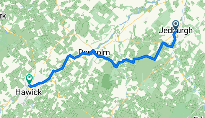
St Wilfrid's Way - Jedburgh to Hawick
Un itinéraire vélo au départ de Jedburgh, Ecosse, Royaume-Uni.
Vue d'ensemble
À propos du circuit
This route follows the well-signposted - with a W - the Borders Abbey Way from Jedburgh to Hawick.
Mainly rough track through moorland with numerous wooden stiles or gates, to villages of Bedrule and then Denholm, then riverside track to Selkirk.
In places, tough for cyclists.
Quite hilly with some great views around Black Law Hill. and over Rubers Law.
Hawick is a busy town . Some pubs,shops and B&Bs. Also at Denholm.
This is the 5th section of the great pilgrim trail, St Wilfrid’s Way, from Hexham to Edinburgh and then on to St Andrews (website:http://www.thewayofstandrews.com/)
- -:--
- Durée
- 20,9 km
- Distance
- 419 m
- Montée
- 399 m
- Descente
- ---
- Vit. moyenne
- ---
- Altitude max.

Continuer avec Bikemap
Utilise, modifie ou télécharge cet itinéraire vélo
Tu veux parcourir St Wilfrid's Way - Jedburgh to Hawick ou l’adapter à ton propre voyage ? Voici ce que tu peux faire avec cet itinéraire Bikemap :
Fonctionnalités gratuites
- Enregistre cet itinéraire comme favori ou dans une collection
- Copie et planifie ta propre version de cet itinéraire
- Synchronise ton itinéraire avec Garmin ou Wahoo
Fonctionnalités Premium
Essai gratuit de 3 jours, ou paiement unique. En savoir plus sur Bikemap Premium.
- Navigue sur cet itinéraire sur iOS et Android
- Exporter un fichier GPX / KML de cet itinéraire
- Crée ton impression personnalisée (essaie-la gratuitement)
- Télécharge cet itinéraire pour la navigation hors ligne
Découvre plus de fonctionnalités Premium.
Obtiens Bikemap PremiumDe notre communauté
Jedburgh : Autres itinéraires populaires qui commencent ici
 Jedburgh to Kelso
- Distance
- 39,7 km
- Montée
- 577 m
- Descente
- 600 m
- Emplacement
- Jedburgh, Ecosse, Royaume-Uni
 Border Castles
- Distance
- 41,4 km
- Montée
- 333 m
- Descente
- 252 m
- Emplacement
- Jedburgh, Ecosse, Royaume-Uni
 4 ABBEYS DAY 2
- Distance
- 36,4 km
- Montée
- 357 m
- Descente
- 366 m
- Emplacement
- Jedburgh, Ecosse, Royaume-Uni
 20160731_144124.gpx
- Distance
- 1,4 km
- Montée
- 18 m
- Descente
- 56 m
- Emplacement
- Jedburgh, Ecosse, Royaume-Uni
 09 Jedburgh naar Chollerford
- Distance
- 77,4 km
- Montée
- 1 274 m
- Descente
- 1 301 m
- Emplacement
- Jedburgh, Ecosse, Royaume-Uni
 Tweedbank Denholm Ancrum Loop - 2 nights
- Distance
- 80,3 km
- Montée
- 707 m
- Descente
- 740 m
- Emplacement
- Jedburgh, Ecosse, Royaume-Uni
 Carter Bar
- Distance
- 8,2 km
- Montée
- 315 m
- Descente
- 32 m
- Emplacement
- Jedburgh, Ecosse, Royaume-Uni
 CARTER BAR, por Southdean
- Distance
- 7,3 km
- Montée
- 237 m
- Descente
- 14 m
- Emplacement
- Jedburgh, Ecosse, Royaume-Uni
Ouvre-la dans l’app