

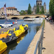
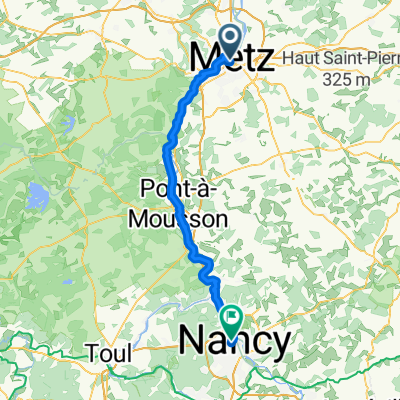
Camino 2015 02 Metz nach Toul
Un itinéraire vélo au départ de Metz, Grand Est, France.
Vue d'ensemble
À propos du circuit
<table border="0" cellpadding="0" cellspacing="0" style="width:445px;" width="444"> <colgroup> <col /> <col /> <col /> <col /> </colgroup> <tbody> <tr height="37"> <td align="right" height="37" style="height:37px;width:75px;"> </td> <td style="width:65px;"> </td> <td colspan="2" style="width:305px;"> Metz</td> </tr> <tr height="22"> <td height="22" style="height:22px;width:75px;"> 13,0</td> <td style="width:65px;"> 13,0</td> <td> Ancy-sur-Moselle</td> <td> </td> </tr> <tr height="21"> <td height="21" style="height:21px;width:75px;"> 32,0</td> <td style="width:65px;"> 19,0</td> <td> Pont a Mousson</td> <td> </td> </tr> <tr height="21"> <td height="21" style="height:21px;width:75px;"> 55,0</td> <td style="width:65px;"> 23,0</td> <td> Pompey</td> <td> </td> </tr> <tr height="21"> <td height="21" style="height:21px;width:75px;"> 57,0</td> <td style="width:65px;"> 2,0</td> <td> Frouard</td> <td> </td> </tr> <tr height="21"> <td height="21" style="height:21px;width:75px;"> 62,0</td> <td style="width:65px;"> 5,0</td> <td> Liverdun</td> <td> </td> </tr> <tr height="21"> <td height="21" style="height:21px;width:75px;"> 69,0</td> <td style="width:65px;"> 7,0</td> <td> Villey-Saint-Étienne</td> <td> </td> </tr> <tr height="22"> <td height="22" style="height:22px;width:75px;"> 82,0</td> <td style="width:65px;"> 13,0</td> <td> Toul</td> <td> </td> </tr> </tbody> </table> <h1 class="item" style="margin: 0px; font-size: 1.0em; color: rgb(0, 53, 128); font-family: Helvetica, sans-serif;"> Hotel De L'Europe<br /> 373 Avenue Victor Hugo<br /> 54200 Toul<br /> Telefon +33383430010</h1>
- -:--
- Durée
- 83,7 km
- Distance
- 171 m
- Montée
- 121 m
- Descente
- ---
- Vit. moyenne
- ---
- Altitude max.

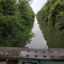
Qualité de l’itinéraire
Types de voies et surfaces le long de l’itinéraire
Types de routes
Sentier
28,1 km
(34 %)
Route tranquille
15,8 km
(19 %)
surfaces
Pavé
60,8 km
(73 %)
Non pavé
9,4 km
(11 %)
Asphalte
59,1 km
(71 %)
Non pavé (non défini)
4,4 km
(5 %)
Points forts de l’itinéraire
Points d’intérêt le long de l’itinéraire
Point d'intérêt après 83 km
Hotel La Villa Lorraine Smart Deal 15,rue gambetta, 54200 Toul
Continuer avec Bikemap
Utilise, modifie ou télécharge cet itinéraire vélo
Tu veux parcourir Camino 2015 02 Metz nach Toul ou l’adapter à ton propre voyage ? Voici ce que tu peux faire avec cet itinéraire Bikemap :
Fonctionnalités gratuites
- Enregistre cet itinéraire comme favori ou dans une collection
- Copie et planifie ta propre version de cet itinéraire
- Divise-le en étapes pour créer un tour sur plusieurs jours
- Synchronise ton itinéraire avec Garmin ou Wahoo
Fonctionnalités Premium
Essai gratuit de 3 jours, ou paiement unique. En savoir plus sur Bikemap Premium.
- Navigue sur cet itinéraire sur iOS et Android
- Exporter un fichier GPX / KML de cet itinéraire
- Crée ton impression personnalisée (essaie-la gratuitement)
- Télécharge cet itinéraire pour la navigation hors ligne
Découvre plus de fonctionnalités Premium.
Obtiens Bikemap PremiumDe notre communauté
Metz : Autres itinéraires populaires qui commencent ici
 Hotel-Laflottille
- Distance
- 17,9 km
- Montée
- 56 m
- Descente
- 63 m
- Emplacement
- Metz, Grand Est, France
 2014 T1 Metz - Thionvill
- Distance
- 36,3 km
- Montée
- 20 m
- Descente
- 52 m
- Emplacement
- Metz, Grand Est, France
 Von Metz via Mosel und Rhein nach Veltins-Arena auf Schalke
- Distance
- 530,4 km
- Montée
- 3 433 m
- Descente
- 3 581 m
- Emplacement
- Metz, Grand Est, France
 FR1 5: Metz - Nancy; 72km 90hm
- Distance
- 72 km
- Montée
- 225 m
- Descente
- 204 m
- Emplacement
- Metz, Grand Est, France
 VeloRoute SaarLorLux - VeloRoute SaarLorLux
- Distance
- 547,2 km
- Montée
- 6 645 m
- Descente
- 6 646 m
- Emplacement
- Metz, Grand Est, France
 FR1-05_Metz - Nancy 68,3km 140hm
- Distance
- 68,9 km
- Montée
- 151 m
- Descente
- 127 m
- Emplacement
- Metz, Grand Est, France
 D2 : Metz-Nancy
- Distance
- 69,5 km
- Montée
- 169 m
- Descente
- 143 m
- Emplacement
- Metz, Grand Est, France
 Von Metz bis Pont-à-Mousson
- Distance
- 35,1 km
- Montée
- 74 m
- Descente
- 73 m
- Emplacement
- Metz, Grand Est, France
Ouvre-la dans l’app