
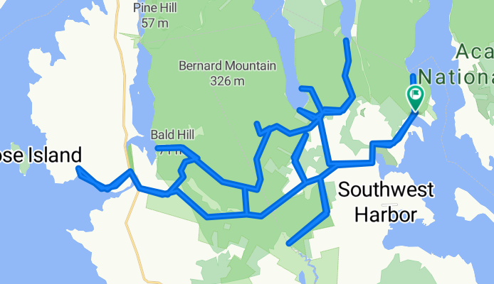
Western side of Acadia
Un itinéraire vélo au départ de Tremont, State of Maine, United States of America.
Vue d'ensemble
À propos du circuit
This route travels on about 65% dirt roads (with a short section of non-technical trail riding), and 35% pavement, and there is a short non-technical trail section. A number of these dirt roads are one lane and are out in a thick forest, with green moss making up the forest bed. It's really nice on a sunny day.
On Cape Road there are a few picnic tables near a small harbor and boat launch. There is a great view here while snacking on the Clif Bar. About 2/3rds way through is a fire road that takes you to the southernmost point. It ends at a small body of water that eventually becomes Bass Harbor. It's in the middle of nowhere. Parking it at the trail head for Flying Mtn.- -:--
- Durée
- 44,7 km
- Distance
- 420 m
- Montée
- 420 m
- Descente
- ---
- Vit. moyenne
- ---
- Altitude max.
Qualité de l’itinéraire
Types de voies et surfaces le long de l’itinéraire
Types de routes
Route tranquille
27,1 km
(61 %)
Route d'accès
5,9 km
(13 %)
surfaces
Pavé
4 km
(9 %)
Non pavé
15,1 km
(34 %)
Non pavé (non défini)
15,1 km
(34 %)
Asphalte
4 km
(9 %)
Indéfini
25,5 km
(57 %)
Points forts de l’itinéraire
Points d’intérêt le long de l’itinéraire
Point d'intérêt après 25,4 km
Picnic table with a great view while chewing on the Clif Bar.
Continuer avec Bikemap
Utilise, modifie ou télécharge cet itinéraire vélo
Tu veux parcourir Western side of Acadia ou l’adapter à ton propre voyage ? Voici ce que tu peux faire avec cet itinéraire Bikemap :
Fonctionnalités gratuites
- Enregistre cet itinéraire comme favori ou dans une collection
- Copie et planifie ta propre version de cet itinéraire
- Synchronise ton itinéraire avec Garmin ou Wahoo
Fonctionnalités Premium
Essai gratuit de 3 jours, ou paiement unique. En savoir plus sur Bikemap Premium.
- Navigue sur cet itinéraire sur iOS et Android
- Exporter un fichier GPX / KML de cet itinéraire
- Crée ton impression personnalisée (essaie-la gratuitement)
- Télécharge cet itinéraire pour la navigation hors ligne
Découvre plus de fonctionnalités Premium.
Obtiens Bikemap PremiumDe notre communauté
Tremont : Autres itinéraires populaires qui commencent ici
 Western side of Acadia
- Distance
- 44,7 km
- Montée
- 420 m
- Descente
- 420 m
- Emplacement
- Tremont, State of Maine, United States of America
 Route from 26 Harborside Rd, Mount Desert
- Distance
- 4 km
- Montée
- 153 m
- Descente
- 90 m
- Emplacement
- Tremont, State of Maine, United States of America
 USBR1 via 1A Southwest Harbor to Portland
- Distance
- 304,2 km
- Montée
- 620 m
- Descente
- 631 m
- Emplacement
- Tremont, State of Maine, United States of America
 southwest harbor to cadillac mt and back
- Distance
- 47,2 km
- Montée
- 593 m
- Descente
- 602 m
- Emplacement
- Tremont, State of Maine, United States of America
 Shore Road 117, Southwest Harbor to Seawall Point Lane 30, Southwest Harbor
- Distance
- 3,1 km
- Montée
- 14 m
- Descente
- 22 m
- Emplacement
- Tremont, State of Maine, United States of America
 7 Bridges
- Distance
- 24,3 km
- Montée
- 0 m
- Descente
- 4 m
- Emplacement
- Tremont, State of Maine, United States of America
 round mini mound
- Distance
- 6,6 km
- Montée
- 103 m
- Descente
- 100 m
- Emplacement
- Tremont, State of Maine, United States of America
 Around Mountain & 7 Bridges
- Distance
- 24,1 km
- Montée
- 26 m
- Descente
- 22 m
- Emplacement
- Tremont, State of Maine, United States of America
Ouvre-la dans l’app