
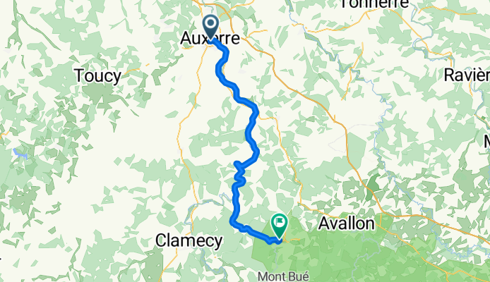
Camino 2015 10 Auxerre nach Vezelay
Un itinéraire vélo au départ de Auxerre, Bourgogne-Franche-Comté, France.
Vue d'ensemble
À propos du circuit
à partir de km 42 jusqu'à km 51, montée de plus en plus raide (130 hm)à partir de km 53 jusqu'à km 55, 40 hm de montéepuis descente raideavant Vézelay, encore une montéeHôtel Le Compostelle1 Place du Champ de Foire,89450 Vézelay,Tel:+33 3 86 33 28 63
- -:--
- Durée
- 58,3 km
- Distance
- 299 m
- Montée
- 168 m
- Descente
- ---
- Vit. moyenne
- ---
- Altitude max.

Qualité de l’itinéraire
Types de voies et surfaces le long de l’itinéraire
Types de routes
Piste cyclable
19,8 km
(34 %)
Route tranquille
7,6 km
(13 %)
surfaces
Pavé
42,6 km
(73 %)
Non pavé
0,6 km
(1 %)
Asphalte
41,4 km
(71 %)
Pavé (non défini)
1,2 km
(2 %)
Continuer avec Bikemap
Utilise, modifie ou télécharge cet itinéraire vélo
Tu veux parcourir Camino 2015 10 Auxerre nach Vezelay ou l’adapter à ton propre voyage ? Voici ce que tu peux faire avec cet itinéraire Bikemap :
Fonctionnalités gratuites
- Enregistre cet itinéraire comme favori ou dans une collection
- Copie et planifie ta propre version de cet itinéraire
- Synchronise ton itinéraire avec Garmin ou Wahoo
Fonctionnalités Premium
Essai gratuit de 3 jours, ou paiement unique. En savoir plus sur Bikemap Premium.
- Navigue sur cet itinéraire sur iOS et Android
- Exporter un fichier GPX / KML de cet itinéraire
- Crée ton impression personnalisée (essaie-la gratuitement)
- Télécharge cet itinéraire pour la navigation hors ligne
Découvre plus de fonctionnalités Premium.
Obtiens Bikemap PremiumDe notre communauté
Auxerre : Autres itinéraires populaires qui commencent ici
 Burgund - Auxerre - Yonne - Canal de Nivernais
- Distance
- 49,7 km
- Montée
- 389 m
- Descente
- 348 m
- Emplacement
- Auxerre, Bourgogne-Franche-Comté, France
 Parcours Casse-pattes dans le Chablisien
- Distance
- 76 km
- Montée
- 861 m
- Descente
- 859 m
- Emplacement
- Auxerre, Bourgogne-Franche-Comté, France
 Route to Commelle-Vernay
- Distance
- 404 km
- Montée
- 1 446 m
- Descente
- 1 445 m
- Emplacement
- Auxerre, Bourgogne-Franche-Comté, France
 auxerre-clamecy
- Distance
- 64,2 km
- Montée
- 120 m
- Descente
- 95 m
- Emplacement
- Auxerre, Bourgogne-Franche-Comté, France
 Parcours n° 1
- Distance
- 54,7 km
- Montée
- 381 m
- Descente
- 380 m
- Emplacement
- Auxerre, Bourgogne-Franche-Comté, France
 Canal du Nivernais with POI
- Distance
- 183,2 km
- Montée
- 331 m
- Descente
- 237 m
- Emplacement
- Auxerre, Bourgogne-Franche-Comté, France
 Girolibero: Il Canale di Borgogna e del Nivernais
- Distance
- 257,3 km
- Montée
- 1 120 m
- Descente
- 995 m
- Emplacement
- Auxerre, Bourgogne-Franche-Comté, France
 From Sens to Samoreau
- Distance
- 129,4 km
- Montée
- 250 m
- Descente
- 307 m
- Emplacement
- Auxerre, Bourgogne-Franche-Comté, France
Ouvre-la dans l’app