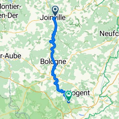
Camino 2015 5b Joinville nach Clairvaux
Un itinéraire vélo au départ de Joinville, Grand Est, France.
Vue d'ensemble
À propos du circuit
<table border="0" cellpadding="0" cellspacing="0" style="width:360px;" width="360"> <colgroup> <col /> <col /> <col /> <col /> <col span="3" /> </colgroup> <tbody> <tr height="21"> <td height="21" style="height:21px;width:34px;"> 10,5</td> <td style="width:34px;"> 10,5</td> <td colspan="2" style="width:98px;"> Donjeux</td> <td style="width:64px;"> </td> <td style="width:64px;"> </td> <td style="width:64px;"> </td> </tr> <tr height="21"> <td height="21" style="height:21px;width:34px;"> 20,0</td> <td style="width:34px;"> 9,5</td> <td colspan="5"> Les Herbues/Ende Radweg (---> D186)</td> </tr> <tr height="21"> <td height="21" style="height:21px;width:34px;"> 23,5</td> <td style="width:34px;"> 3,5</td> <td colspan="4"> Cerisieres (2km Anstieg)</td> <td> </td> </tr> <tr height="21"> <td height="21" style="height:21px;width:34px;"> 29,0</td> <td style="width:34px;"> 5,5</td> <td colspan="2"> Marbéville</td> <td> </td> <td> </td> <td> </td> </tr> <tr height="21"> <td height="21" style="height:21px;width:34px;"> 33,4</td> <td style="width:34px;"> 4,4</td> <td colspan="5"> Abzweig nach Curmont/Lamothe --> D133)</td> </tr> <tr height="21"> <td height="21" style="height:21px;width:34px;"> 35,4</td> <td style="width:34px;"> 2,0</td> <td colspan="4"> Curmont rechts liegen lassen </td> <td> </td> </tr> <tr height="21"> <td height="21" style="height:21px;width:34px;"> 37,9</td> <td style="width:34px;"> 2,5</td> <td colspan="5"> Lamothe-en-Blaisy ---> Colombey --> D235</td> </tr> <tr height="21"> <td height="21" style="height:21px;width:34px;"> 42,9</td> <td style="width:34px;"> 5,0</td> <td colspan="4"> Colombey-les-deux-eglises</td> <td> </td> </tr> <tr height="21"> <td height="21" style="height:21px;width:34px;"> 46,2</td> <td style="width:34px;"> 3,3</td> <td colspan="5"> Abzweig im Wald - braunes Schild</td> </tr> <tr height="21"> <td height="21" style="height:21px;width:34px;"> 50,0</td> <td style="width:34px;"> 3,8</td> <td colspan="2"> ---> rechts</td> <td> </td> <td> </td> <td> </td> </tr> <tr height="21"> <td height="21" style="height:21px;width:34px;"> 55,5</td> <td style="width:34px;"> 5,5</td> <td colspan="2"> Clairvaux</td> <td> </td> <td> </td> <td> </td> </tr> </tbody> </table>
nach Verlassen des Radweges bei km 20<br /> ca. 3 km Anstieg um ca. 130 hm<br /> dann 10 km hügelig abwärts,<br /> D133 sieht super aus<br /> danach 10 km hügelig bergan<br /> bei km 52 steil bergab Hôtel Restaurant de l'Abbaye<br /> 19, route de Dijon 10310 Clairvaux<br /> Telefon +33325278012- -:--
- Durée
- 55,8 km
- Distance
- 378 m
- Montée
- 368 m
- Descente
- ---
- Vit. moyenne
- ---
- Altitude max.
Qualité de l’itinéraire
Types de voies et surfaces le long de l’itinéraire
Types de routes
Route
18 km
(32 %)
Route d'accès
14,9 km
(27 %)
surfaces
Pavé
43,7 km
(78 %)
Non pavé
0,7 km
(1 %)
Asphalte
29 km
(52 %)
Pavé (non défini)
14,7 km
(26 %)
Continuer avec Bikemap
Utilise, modifie ou télécharge cet itinéraire vélo
Tu veux parcourir Camino 2015 5b Joinville nach Clairvaux ou l’adapter à ton propre voyage ? Voici ce que tu peux faire avec cet itinéraire Bikemap :
Fonctionnalités gratuites
- Enregistre cet itinéraire comme favori ou dans une collection
- Copie et planifie ta propre version de cet itinéraire
- Synchronise ton itinéraire avec Garmin ou Wahoo
Fonctionnalités Premium
Essai gratuit de 3 jours, ou paiement unique. En savoir plus sur Bikemap Premium.
- Navigue sur cet itinéraire sur iOS et Android
- Exporter un fichier GPX / KML de cet itinéraire
- Crée ton impression personnalisée (essaie-la gratuitement)
- Télécharge cet itinéraire pour la navigation hors ligne
Découvre plus de fonctionnalités Premium.
Obtiens Bikemap PremiumDe notre communauté
Joinville : Autres itinéraires populaires qui commencent ici
 lac 1
lac 1- Distance
- 52,4 km
- Montée
- 747 m
- Descente
- 749 m
- Emplacement
- Joinville, Grand Est, France
 italy day 3
- Distance
- 218,7 km
- Montée
- 2 474 m
- Descente
- 2 281 m
- Emplacement
- Joinville, Grand Est, France
 Paris 8
- Distance
- 141,5 km
- Montée
- 82 m
- Descente
- 255 m
- Emplacement
- Joinville, Grand Est, France
 Taizé 20-5
- Distance
- 94,5 km
- Montée
- 293 m
- Descente
- 38 m
- Emplacement
- Joinville, Grand Est, France
 Joinville - Epernay
- Distance
- 130,4 km
- Montée
- 258 m
- Descente
- 373 m
- Emplacement
- Joinville, Grand Est, France
 10A Echenay - Ville-sous-la-Ferté Jakobsweg
- Distance
- 69,1 km
- Montée
- 634 m
- Descente
- 735 m
- Emplacement
- Joinville, Grand Est, France
 Joinville - Rolampont
- Distance
- 74,3 km
- Montée
- 387 m
- Descente
- 270 m
- Emplacement
- Joinville, Grand Est, France
 Camino 2015 05b Joinville nach Clairvaux
- Distance
- 59,6 km
- Montée
- 373 m
- Descente
- 388 m
- Emplacement
- Joinville, Grand Est, France
Ouvre-la dans l’app


