

Sun City Bike Club Hard Ride 4 Out and Back Through Neighborhoods and To the Landfill
Un itinéraire vélo au départ de Mesquite, Nevada, États Unis.
Vue d'ensemble
À propos du circuit
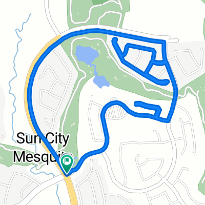
This ride begins at the corner of Flat Top Mesa Drive and Falcon Ridge Parkway; riders head South on Falcon Ridge Parkway to Hardy Way; turning right onto Hardy Way, the ride now seriously climbs a short distance and then descends to a right turn (walking the bike around a fence and barricades) onto Greens Way; the ride continues on Greens Way through a roundabout to a left turn onto Fountain View Lane; almost immediately, riders turn right onto Redd Hills Parkway and continue to West Pioneer Boulevard; turning left (East) onto West Pioneer Boulevard, riders climb and descend several times until they reach Oasis Boulevard where they turn right; continuing on Oasis Boulevard, the ride gently climbs, passing through two roundabouts (staying left each time and remaining on Oasis Boulevard) until riders bear left onto Canyon Crest Boulevard; here riders make a steady climb on Canyon Crest Boulevard to Mesquite Heights Road (aka the "dump road"), where they turn right; the ride continues on the dump road as it follows a series of rollers and climbs to the landfill; turning around at the landfill, riders now re-trace their route on the dump road until they reach the Stone Haven development; there they turn left onto Mendicino Lane, then left onto Manchester Lane, jog right onto Coventry Lane, again jogging right onto Stone Haven Street and Stone Haven Lane; the ride leaves Stone Haven as it turns left onto Kensington Avenue and a downhill to Oasis Boulevard; turning right onto Oasis Boulevard, the ride continues to the Sierra Ridge development; turning right into Sierra Ridge at Lasso Lane, riders advance through Sierra Ridge by turning right onto Saddle Way and jogging left onto Wild Horse Lane; the ride leaves Sierra Ridge as it turns left onto Wingate Drive and entering a roundabout after passing the "Sphinx of Mesquite"; riders exit the roundabout with a right jog back onto Oasis Boulevard and continue on a slight downhill through the roundabout, then turning right back onto Canyon Crest Boulevard for the steady climb back to the dump road; riders cross the dump road and continue on Canyon Crest Boulevard downhill, where it jogs left onto Horizon Boulevard; riders make a descent and then make a short steep climb on Horizon Boulevard to Hardy Way, where they turn right; the ride continues West on Hardy Way, climbing and then descending to Falcon Ridge Parkway; the ride ends with a right turn onto Falcon Ridge Parkway and a gentle climb back to the corner of Falcon Ridge Parkway and Flat Top Mesa Drive. Total Ride Distance: 20.5 Miles.
For those who want additional punishment, the ride can be extended by (1) a steep climb on Kitty Hawk Lane (a right turn off of Oasis Boulevard) to the airport, which adds 2 miles; and (2) a very steep climb on the road to the water tower (a left turn off of the dump road), which adds 1 1/2 miles. Notes: 1. If you open the route in Google Roadmap or Google Hybrid (pulled down from the "Relief Map" tab) you will get a more up-to-date view of the roads and paths. Some of the other maps are dated. 2. This mapping program tends to under-compute the total ride mileage by roughly 10%, based on mileage for this ride when it has been actually ridden.- -:--
- Durée
- 33 km
- Distance
- 371 m
- Montée
- 374 m
- Descente
- ---
- Vit. moyenne
- ---
- Altitude max.
Qualité de l’itinéraire
Types de voies et surfaces le long de l’itinéraire
Types de routes
Route
17,2 km
(52 %)
Route fréquentée
13 km
(39 %)
surfaces
Pavé
6,7 km
(20 %)
Asphalte
6,5 km
(20 %)
Pavé (non défini)
0,2 km
(<1 %)
Indéfini
26,4 km
(80 %)
Continuer avec Bikemap
Utilise, modifie ou télécharge cet itinéraire vélo
Tu veux parcourir Sun City Bike Club Hard Ride 4 Out and Back Through Neighborhoods and To the Landfill ou l’adapter à ton propre voyage ? Voici ce que tu peux faire avec cet itinéraire Bikemap :
Fonctionnalités gratuites
- Enregistre cet itinéraire comme favori ou dans une collection
- Copie et planifie ta propre version de cet itinéraire
- Synchronise ton itinéraire avec Garmin ou Wahoo
Fonctionnalités Premium
Essai gratuit de 3 jours, ou paiement unique. En savoir plus sur Bikemap Premium.
- Navigue sur cet itinéraire sur iOS et Android
- Exporter un fichier GPX / KML de cet itinéraire
- Crée ton impression personnalisée (essaie-la gratuitement)
- Télécharge cet itinéraire pour la navigation hors ligne
Découvre plus de fonctionnalités Premium.
Obtiens Bikemap PremiumDe notre communauté
Mesquite : Autres itinéraires populaires qui commencent ici
 Mesquite half loop.
- Distance
- 17,6 km
- Montée
- 253 m
- Descente
- 256 m
- Emplacement
- Mesquite, Nevada, États Unis
 870 Deep Gorge Trail, Mesquite to 1350 Flat Top Mesa Dr, Mesquite
- Distance
- 27,3 km
- Montée
- 281 m
- Descente
- 243 m
- Emplacement
- Mesquite, Nevada, États Unis
 1350 Flat Top Mesa Dr, Mesquite to 1173 Clouds Rest Pt, Mesquite
- Distance
- 0,9 km
- Montée
- 21 m
- Descente
- 32 m
- Emplacement
- Mesquite, Nevada, États Unis
 Sun City Bike Club Easy Ride 3 (Tannery Cove)
- Distance
- 4,5 km
- Montée
- 114 m
- Descente
- 114 m
- Emplacement
- Mesquite, Nevada, États Unis
 Sun City Bike Club Easy Ride 4 (Wagon Wheel, Overland Trail and Frontier Pass Neighborhoods)
- Distance
- 5 km
- Montée
- 91 m
- Descente
- 89 m
- Emplacement
- Mesquite, Nevada, États Unis
 Mesquite, NV - Dolan Springs, NV
- Distance
- 238,4 km
- Montée
- 1 600 m
- Descente
- 1 046 m
- Emplacement
- Mesquite, Nevada, États Unis
 Sun City Bike Club Easy Ride 2 Out and Back Around Mesquite (With Some Climbs)
- Distance
- 20,1 km
- Montée
- 81 m
- Descente
- 82 m
- Emplacement
- Mesquite, Nevada, États Unis
 Cycle-a-thon for Cancer
- Distance
- 16,3 km
- Montée
- 132 m
- Descente
- 162 m
- Emplacement
- Mesquite, Nevada, États Unis
Ouvre-la dans l’app