
home fitness inline
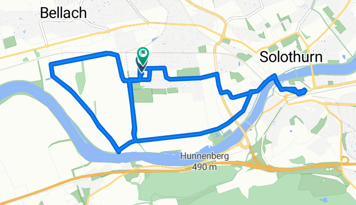
Un itinéraire vélo au départ de Langendorf, Canton of Solothurn, Switzerland.
Vue d'ensemble
À propos du circuit
07.05.15 20:53
- -:--
- Durée
- 15,5 km
- Distance
- 19 m
- Montée
- 20 m
- Descente
- ---
- Vit. moyenne
- ---
- Altitude max.
Qualité de l’itinéraire
Types de voies et surfaces le long de l’itinéraire
Types de routes
Route tranquille
8,1 km
(52 %)
Route d'accès
3,4 km
(22 %)
surfaces
Pavé
14,3 km
(92 %)
Asphalte
12,9 km
(83 %)
Pavé (non défini)
1,4 km
(9 %)
Indéfini
1,2 km
(8 %)
Continuer avec Bikemap
Utilise, modifie ou télécharge cet itinéraire vélo
Tu veux parcourir home fitness inline ou l’adapter à ton propre voyage ? Voici ce que tu peux faire avec cet itinéraire Bikemap :
Fonctionnalités gratuites
- Enregistre cet itinéraire comme favori ou dans une collection
- Copie et planifie ta propre version de cet itinéraire
- Synchronise ton itinéraire avec Garmin ou Wahoo
Fonctionnalités Premium
Essai gratuit de 3 jours, ou paiement unique. En savoir plus sur Bikemap Premium.
- Navigue sur cet itinéraire sur iOS et Android
- Exporter un fichier GPX / KML de cet itinéraire
- Crée ton impression personnalisée (essaie-la gratuitement)
- Télécharge cet itinéraire pour la navigation hors ligne
Découvre plus de fonctionnalités Premium.
Obtiens Bikemap PremiumDe notre communauté
Langendorf : Autres itinéraires populaires qui commencent ici
 Bellach / Weissenstein / Balmberg / Solothurn / Bellach
- Distance
- 28,8 km
- Montée
- 1 087 m
- Descente
- 1 090 m
- Emplacement
- Langendorf, Canton of Solothurn, Switzerland
 Sonntagsabendtour zur Schauenburg
- Distance
- 24 km
- Montée
- 846 m
- Descente
- 846 m
- Emplacement
- Langendorf, Canton of Solothurn, Switzerland
 Slowup Buechibärg
- Distance
- 48,7 km
- Montée
- 315 m
- Descente
- 324 m
- Emplacement
- Langendorf, Canton of Solothurn, Switzerland
 Laufenburg
- Distance
- 86,2 km
- Montée
- 471 m
- Descente
- 601 m
- Emplacement
- Langendorf, Canton of Solothurn, Switzerland
 Weissensteinstrasse 187, Oberdorf nach Weissensteinstrasse 187, Oberdorf
- Distance
- 60,5 km
- Montée
- 1 195 m
- Descente
- 1 364 m
- Emplacement
- Langendorf, Canton of Solothurn, Switzerland
 Bellach Langenthal Haslibräu
- Distance
- 28,3 km
- Montée
- 147 m
- Descente
- 118 m
- Emplacement
- Langendorf, Canton of Solothurn, Switzerland
 Solothurn-Weissenstein-Grenchen-Solothurn
- Distance
- 26,9 km
- Montée
- 1 003 m
- Descente
- 1 005 m
- Emplacement
- Langendorf, Canton of Solothurn, Switzerland
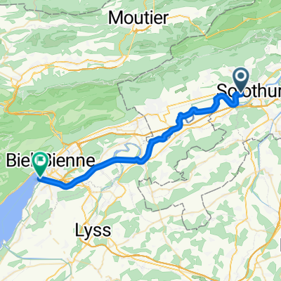 solothurn Biel See
- Distance
- 30,3 km
- Montée
- 24 m
- Descente
- 26 m
- Emplacement
- Langendorf, Canton of Solothurn, Switzerland
Ouvre-la dans l’app