
islandia
Un itinéraire vélo au départ de Keflavík, Péninsule méridionale, Islande.
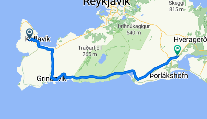
Vue d'ensemble
À propos du circuit
itinéraire préliminaire
- -:--
- Durée
- 91 km
- Distance
- 478 m
- Montée
- 500 m
- Descente
- ---
- Vit. moyenne
- ---
- Altitude max.
Points forts de l’itinéraire
Points d’intérêt le long de l’itinéraire
Point d'intérêt après 14 km
vogar ma niewielki bezpłatny kemping
Point d'intérêt après 19,1 km
blekitna laguna
Point d'intérêt après 19,8 km
błękitna laguna
Point d'intérêt après 21,2 km
pole namiotowe niedaleko basenu (przewodnik mowi ze bezplatne)
Point d'intérêt après 44,3 km
Seltún Geothermal Area
Point d'intérêt après 44,7 km
krysuvik- pola geotermlne
Point d'intérêt après 50,4 km
blekitne jezioro- otoczone czarnymi plazami
Point d'intérêt après 87,8 km
Raufarholshellir - tunel w lawie ale trzeba miec latarke
Point d'intérêt après 91 km
skogarfoss- wodospad, obok pole namiotowe, bezplatne ale licza na datki parking
Point d'intérêt après 91 km
porsmork- lasy thora jest jakas trasa z porsmorku do kogaru miedzy dwoma lodowcami pola namiotowe przy schornisku
Point d'intérêt après 91 km
trasa z porsmork do skodar- -
Point d'intérêt après 91 km
seljalandsfoss- nwidac z drogi nr 1 wodospad
Point d'intérêt après 91 km
basen, sklep 10-11,
Point d'intérêt après 91 km
biuro informacji ? cpn olis, supermarket
Point d'intérêt après 91 km
kompieisko termalne
Point d'intérêt après 91 km
gdzies darmowy kemping
Point d'intérêt après 91 km
kompielisko termalne
Point d'intérêt après 91 km
informacja
Point d'intérêt après 91 km
centrum handlowe-kjarninn
Point d'intérêt après 91 km
pole namiotowe
Point d'intérêt après 91 km
kemping, ciepla woda, miejsca do gotowania
Point d'intérêt après 91 km
kompielisko termalne do 20,30
Point d'intérêt après 91 km
gufudalur-zrodla goracej wody, blota i gejzery0- gryla
Point d'intérêt après 91 km
kemping, gorace zrodla sklep bank
Point d'intérêt après 91 km
kerid- krater wypelniony zielonymi wodami
Point d'intérêt après 91 km
reykholt- kompielisko termalne
Point d'intérêt après 91 km
uskok almannagja i niedaleko wospad oxarafoss
Point d'intérêt après 91 km
kemping vatnskot
Point d'intérêt après 91 km
kemping leirar i Informacja
Point d'intérêt après 91 km
kemping
Point d'intérêt après 91 km
kemping
Point d'intérêt après 91 km
kemping
Point d'intérêt après 91 km
pingvellir almannagja- uskok tektoniczny oxarafoss- wodospad 5 kempingow90 (leirarze)(vatnskot)
Point d'intérêt après 91 km
Gullfoss
Point d'intérêt après 91 km
camping (tylko umywalki), dalej wśród wzgórz można na dziko strokkur, geysir
Point d'intérêt après 91 km
Reykjadalur - godzinę piechota od miasta naturalne gorące źródła, kemping Reykjamörk IS-6810 Hveragerðii bonus w centrum sadzawki blotne, gorace zrodelka i baseny
Point d'intérêt après 91 km
kemping (N64° 13' 14.872" W20° 43' 55.761") przy szosie tuz za wsia
Point d'intérêt après 91 km
Laugarvatn Fontana- do 23 100 zł
Point d'intérêt après 91 km
jest podniszczona naturalna sauna
Point d'intérêt après 91 km
laka
Point d'intérêt après 91 km
Fagrifoss
Point d'intérêt après 91 km
Skaftafell
Point d'intérêt après 91 km
Svartifoss
Point d'intérêt après 91 km
Jökulsárlón
Point d'intérêt après 91 km
cazrne plaze- myrdalssandur
Point d'intérêt après 91 km
Dyrhólaey- luk skalny pod ktory mozna przeplynac
Point d'intérêt après 91 km
Reynisfjara- czarna wulkaniczna plaza
Point d'intérêt après 91 km
reynisdrangur- skaly wystajace z nad oceanu
Point d'intérêt après 91 km
Lofthellir,
Point d'intérêt après 91 km
kemping
Point d'intérêt après 91 km
Hverarönd- pole geotermalne
Point d'intérêt après 91 km
Mývatn
Point d'intérêt après 91 km
Ásbyrgi.
Point d'intérêt après 91 km
Hafragilsfoss
Point d'intérêt après 91 km
Dettifoss
Point d'intérêt après 91 km
plaze z czarnym piachem(deszcz pada najczesceij w islandi)
Point d'intérêt après 91 km
Landmannalaugar
Continuer avec Bikemap
Utilise, modifie ou télécharge cet itinéraire vélo
Tu veux parcourir islandia ou l’adapter à ton propre voyage ? Voici ce que tu peux faire avec cet itinéraire Bikemap :
Fonctionnalités gratuites
- Enregistre cet itinéraire comme favori ou dans une collection
- Copie et planifie ta propre version de cet itinéraire
- Divise-le en étapes pour créer un tour sur plusieurs jours
- Synchronise ton itinéraire avec Garmin ou Wahoo
Fonctionnalités Premium
Essai gratuit de 3 jours, ou paiement unique. En savoir plus sur Bikemap Premium.
- Navigue sur cet itinéraire sur iOS et Android
- Exporter un fichier GPX / KML de cet itinéraire
- Crée ton impression personnalisée (essaie-la gratuitement)
- Télécharge cet itinéraire pour la navigation hors ligne
Découvre plus de fonctionnalités Premium.
Obtiens Bikemap PremiumDe notre communauté
Keflavík : Autres itinéraires populaires qui commencent ici
 Island Tour
- Distance
- 1 326,6 km
- Montée
- 3 316 m
- Descente
- 3 316 m
- Emplacement
- Keflavík, Péninsule méridionale, Islande
 Iceland - Ringroad
- Distance
- 1 511,3 km
- Montée
- 0 m
- Descente
- 0 m
- Emplacement
- Keflavík, Péninsule méridionale, Islande
 islandia
- Distance
- 91 km
- Montée
- 478 m
- Descente
- 500 m
- Emplacement
- Keflavík, Péninsule méridionale, Islande
 Islande, Jour 0
- Distance
- 56,1 km
- Montée
- 177 m
- Descente
- 194 m
- Emplacement
- Keflavík, Péninsule méridionale, Islande
 Norðurvellir, Keflavík to Norðurvellir 54, Keflavík
- Distance
- 17,8 km
- Montée
- 156 m
- Descente
- 181 m
- Emplacement
- Keflavík, Péninsule méridionale, Islande
 IJsland_v1
- Distance
- 1 511,8 km
- Montée
- 2 935 m
- Descente
- 2 922 m
- Emplacement
- Keflavík, Péninsule méridionale, Islande
 Iceland by bike 2017
- Distance
- 1 667,4 km
- Montée
- 0 m
- Descente
- 0 m
- Emplacement
- Keflavík, Péninsule méridionale, Islande
 IJslans_v2
- Distance
- 1 729 km
- Montée
- 2 791 m
- Descente
- 2 778 m
- Emplacement
- Keflavík, Péninsule méridionale, Islande
Ouvre-la dans l’app