Javornice, Berounka a Rakovnický potok
Un itinéraire vélo au départ de Kožlany, Plzeňský kraj, République tchèque.
Vue d'ensemble
À propos du circuit
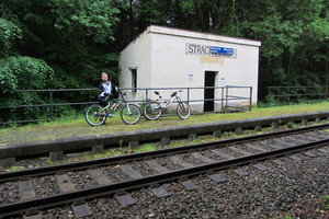
Le départ est à la gare de Strachovice, l'arrivée à la gare de Rakovník. Une balade complètement tranquille avec beaucoup de gués, presque toujours plate sauf quelques côtes, à travers une belle nature. ATTENTION : À partir de Bránov, on emprunte le sentier dit de l'Ermite - Dangereux ! Le sentier est étroit sur un versant raide, risque de chute, blessures graves ou pire. Je recommande de pousser le vélo et pour les enfants, mieux vaut contourner par la route.
- -:--
- Durée
- 56,8 km
- Distance
- 265 m
- Montée
- 407 m
- Descente
- ---
- Vit. moyenne
- ---
- Altitude max.
Qualité de l’itinéraire
Types de voies et surfaces le long de l’itinéraire
Types de routes
Route forestière
20,4 km
(36 %)
Route tranquille
7,4 km
(13 %)
surfaces
Pavé
11,9 km
(21 %)
Non pavé
22,7 km
(40 %)
Asphalte
11,4 km
(20 %)
Non pavé (non défini)
10,8 km
(19 %)
Points forts de l’itinéraire
Points d’intérêt le long de l’itinéraire

Point d'intérêt après 0 km
Start

Point d'intérêt après 3,3 km
Rybník Ožehák

Point d'intérêt après 5,1 km
Krásná lesní cestička, na mokru moc dobrodružná, kola si létají sem a tam...

Point d'intérêt après 8,7 km
Uhrovic mlýn

Point d'intérêt après 8,8 km
Mají tady velbloudy

Point d'intérêt après 9,3 km
Po celé Javornici je spousta brodů

Point d'intérêt après 11,1 km
Machův mlýn - pivní okénko otevřeno již od rána

Point d'intérêt après 12 km
Brody se dají jet i takhle

Point d'intérêt après 12,8 km
Nebo takhle

Point d'intérêt après 13,4 km
Údolí Javornice

Point d'intérêt après 14,4 km
Kdo si nechce namočit kolo jde po lávce

Point d'intérêt après 18,9 km
Tady už se Javornice chystá do Berounky

Point d'intérêt après 19,1 km
Berounka - pohled od piva z kempu

Point d'intérêt après 22,2 km
Výhled západním směrem

Point d'intérêt après 22,2 km
Skála nad Berounkou

Point d'intérêt après 26 km
Skryjský most

Point d'intérêt après 32,4 km
Restaurace U Rozvědčíka

Point d'intérêt après 33,8 km
Branovský přívoz

Point d'intérêt après 34,4 km
Nezabudický "Proškův" mlýn

Point d'intérêt après 36,3 km
Eremitova stezka

Point d'intérêt après 36,6 km
Cedule

Point d'intérêt après 36,8 km
Lávka na stezce

Point d'intérêt après 38,5 km
Roztocký most - pohled proti proudu

Point d'intérêt après 39,6 km
Pohled na Křivoklát

Point d'intérêt après 41 km
Sportoviště a občerstvovna U Kolečka

Point d'intérêt après 41,8 km
Rakovnický potok

Point d'intérêt après 47,9 km
Restaurace Pustověty, o víkendech v sezóně tu jsou country, folk a trampské koncerty, takže se tu dá i moc hezky skončit

Point d'intérêt après 50,6 km
Potok
Continuer avec Bikemap
Utilise, modifie ou télécharge cet itinéraire vélo
Tu veux parcourir Javornice, Berounka a Rakovnický potok ou l’adapter à ton propre voyage ? Voici ce que tu peux faire avec cet itinéraire Bikemap :
Fonctionnalités gratuites
- Enregistre cet itinéraire comme favori ou dans une collection
- Copie et planifie ta propre version de cet itinéraire
- Synchronise ton itinéraire avec Garmin ou Wahoo
Fonctionnalités Premium
Essai gratuit de 3 jours, ou paiement unique. En savoir plus sur Bikemap Premium.
- Navigue sur cet itinéraire sur iOS et Android
- Exporter un fichier GPX / KML de cet itinéraire
- Crée ton impression personnalisée (essaie-la gratuitement)
- Télécharge cet itinéraire pour la navigation hors ligne
Découvre plus de fonctionnalités Premium.
Obtiens Bikemap PremiumDe notre communauté
Kožlany : Autres itinéraires populaires qui commencent ici
 Žel ruda
- Distance
- 167,8 km
- Montée
- 1 239 m
- Descente
- 857 m
- Emplacement
- Kožlany, Plzeňský kraj, République tchèque
 Kostitřas 2020
- Distance
- 58,3 km
- Montée
- 1 141 m
- Descente
- 1 140 m
- Emplacement
- Kožlany, Plzeňský kraj, République tchèque
 cista nach blovice /blowitz)
- Distance
- 61,8 km
- Montée
- 451 m
- Descente
- 539 m
- Emplacement
- Kožlany, Plzeňský kraj, République tchèque
 Bike 2014-Zdeslav-Rakovník-Louny-Teplice
- Distance
- 109,1 km
- Montée
- 664 m
- Descente
- 926 m
- Emplacement
- Kožlany, Plzeňský kraj, République tchèque
 Ztracené kobylky 2103
- Distance
- 43,7 km
- Montée
- 459 m
- Descente
- 459 m
- Emplacement
- Kožlany, Plzeňský kraj, République tchèque
 Kožlany - Rakovník
- Distance
- 27,9 km
- Montée
- 298 m
- Descente
- 418 m
- Emplacement
- Kožlany, Plzeňský kraj, République tchèque
 Brezansky kostitras
- Distance
- 37,2 km
- Montée
- 615 m
- Descente
- 614 m
- Emplacement
- Kožlany, Plzeňský kraj, République tchèque
 2018_07 Krakovec pěšky
- Distance
- 27,7 km
- Montée
- 424 m
- Descente
- 283 m
- Emplacement
- Kožlany, Plzeňský kraj, République tchèque
Ouvre-la dans l’app

