Leon Marshall Wall and Wilson Hill

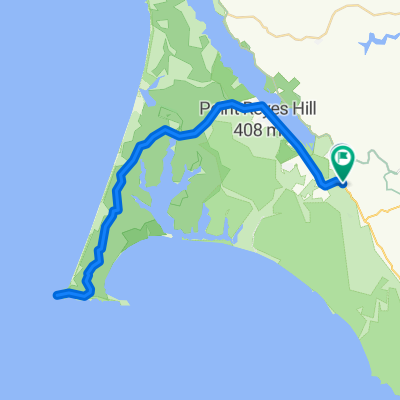
Un itinéraire vélo au départ de Inverness, California, United States of America.

Vue d'ensemble

Ă€ propos du circuit

0

This is Leon Sun's ride

<span style="color: #000000; font-family: arial; font-size: 11px; line-height: 13px;">Will lead a ride on the 20th in <span id="lw_1252646841_0" class="yshortcuts" style="line-height: 1.2em; outline-style: none; outline-width: initial; outline-color: initial; cursor: pointer; background-image: initial; background-repeat: initial; background-attachment: initial; -webkit-background-clip: initial; -webkit-background-origin: initial; background-color: transparent; border-bottom-style: none; border-bottom-width: initial; border-bottom-color: initial; background-position: initial initial;">West Marin</span>. Toward the end of the ride, I want to stop at the G.R.O. Art Gallery in Pt Reyes Station where my friend Lucien Kubo has a solo show. Here are the details of the ride, if you don't mind posting it:<br style="line-height: 1.2em; outline-style: none; outline-width: initial; outline-color: initial;" /><br style="line-height: 1.2em; outline-style: none; outline-width: initial; outline-color: initial;" />Start: 9:00 a.m., <span id="lw_1252646841_1" class="yshortcuts" style="line-height: 1.2em; outline-style: none; outline-width: initial; outline-color: initial; border-bottom-style: dashed; border-bottom-width: 1px; border-bottom-color: #0066cc; cursor: pointer; background-image: initial; background-repeat: initial; background-attachment: initial; -webkit-background-clip: initial; -webkit-background-origin: initial; background-color: transparent; background-position: initial initial;">Bear Valley Visitor Center</span>, <span id="lw_1252646841_2" class="yshortcuts" style="line-height: 1.2em; outline-style: none; outline-width: initial; outline-color: initial; cursor: pointer; background-image: initial; background-repeat: initial; background-attachment: initial; -webkit-background-clip: initial; -webkit-background-origin: initial; background-color: transparent; border-bottom-style: none; border-bottom-width: initial; border-bottom-color: initial; background-position: initial initial;">Bear Valley Rd</span>, <span id="lw_1252646841_3" class="yshortcuts" style="line-height: 1.2em; outline-style: none; outline-width: initial; outline-color: initial; cursor: pointer; background-image: initial; background-repeat: initial; background-attachment: initial; -webkit-background-clip: initial; -webkit-background-origin: initial; background-color: transparent; border-bottom-style: none; border-bottom-width: initial; border-bottom-color: initial; background-position: initial initial;">Olema</span>. <br style="line-height: 1.2em; outline-style: none; outline-width: initial; outline-color: initial;" /><br style="line-height: 1.2em; outline-style: none; outline-width: initial; outline-color: initial;" />Route: Exiting Visitor Center, R onto Bear Valley Rd, L (North) onto Hwy 1, R onto Marshal-Petaluma Rd (Marshall Wall, about 1100' elev gain), L onto <span id="lw_1252646841_4" class="yshortcuts" style="line-height: 1.2em; outline-style: none; outline-width: initial; outline-color: initial;">Wilson Hill Rd</span>, L onto Chileno Valley Rd, L onto Tomales-Petaluma Rd, R onto Hwy 1 to <span id="lw_1252646841_5" class="yshortcuts" style="line-height: 1.2em; outline-style: none; outline-width: initial; outline-color: initial; cursor: pointer; background-image: initial; background-repeat: initial; background-attachment: initial; -webkit-background-clip: initial; -webkit-background-origin: initial; background-color: transparent; border-bottom-style: none; border-bottom-width: initial; border-bottom-color: initial; background-position: initial initial;">Tomales</span>, stop for lunch or snack, Return South on Hwy1 all the way to Bear Valley Rd, turn R, L into Visitor Center.<br style="line-height: 1.2em; outline-style: none; outline-width: initial; outline-color: initial;" /><br style="line-height: 1.2em; outline-style: none; outline-width: initial; outline-color: initial;" />Marshall Wall and Wilson Hill are the two major climbs, about 1500' el.gain combined. The rest are rollers. About 60 miles, total distance. Overlaps parts of Pilgrimage route. Stopping at gallery, of course, is optional.<br style="line-height: 1.2em; outline-style: none; outline-width: initial; outline-color: initial;" /></span>

-:--
Durée
98,3 km
Distance
1 271 m
Montée
1 276 m
Descente
---
Vit. moyenne
220 m
Altitude max.
berkeley_rinaldi

créé il y a il y a 15 ans

Qualité de l’itinéraire

Types de voies et surfaces le long de l’itinéraire

Points forts de l’itinéraire

Points d’intérêt le long de l’itinéraire

  1. Point d'intérêt après 20,3 km

    R Marshall-Petaluma Rod (Marshall Wall about 1100' elev gain)

  2. Point d'intérêt après 42,4 km

    L Chileno Valley Rd

  3. Point d'intérêt après 53,4 km

    R Chileno Valley Rd

  4. Point d'intérêt après 58,1 km

    L Tomales Petaluma Rd.

  5. Point d'intérêt après 67,1 km

  6. Point d'intérêt après 67,8 km

    LUNCH IN TOMALES

  7. Point d'intérêt après 68,4 km

    L Shoreline HWY1

Continuer avec Bikemap

Utilise, modifie ou télécharge cet itinéraire vélo

Tu veux parcourir Leon Marshall Wall and Wilson Hill ou l’adapter à ton propre voyage ? Voici ce que tu peux faire avec cet itinéraire Bikemap :

Fonctionnalités gratuites

Fonctionnalités Premium

Essai gratuit de 3 jours, ou paiement unique. En savoir plus sur Bikemap Premium.

  • Navigue sur cet itinĂ©raire sur iOS et Android
  • Exporter un fichier GPX / KML de cet itinĂ©raire
  • CrĂ©e ton impression personnalisĂ©e (essaie-la gratuitement)
  • TĂ©lĂ©charge cet itinĂ©raire pour la navigation hors ligne

Découvre plus de fonctionnalités Premium.

Obtiens Bikemap Premium

De notre communauté

Inverness : Autres itinéraires populaires qui commencent ici

Ouvre-la dans l’app