

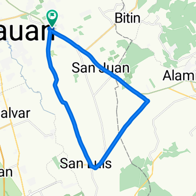
San Vicente to Sta. Cruz to Alaminos and back
Un itinéraire vélo au départ de Tanauan, Calabarzon, Philippines.
Vue d'ensemble
À propos du circuit
Montée jusqu'à Sta. Cruz et descente jusqu'à Sta. Rosa, puis montée jusqu'à San Juan. Majoritairement route pavée.
- -:--
- Durée
- 34,6 km
- Distance
- 300 m
- Montée
- 295 m
- Descente
- ---
- Vit. moyenne
- ---
- Altitude max.
Qualité de l’itinéraire
Types de voies et surfaces le long de l’itinéraire
Types de routes
Route
12,1 km
(35 %)
Piste cyclable
7,3 km
(21 %)
surfaces
Pavé
24,9 km
(72 %)
Asphalte
14,2 km
(41 %)
Béton
10,7 km
(31 %)
Indéfini
9,7 km
(28 %)
Continuer avec Bikemap
Utilise, modifie ou télécharge cet itinéraire vélo
Tu veux parcourir San Vicente to Sta. Cruz to Alaminos and back ou l’adapter à ton propre voyage ? Voici ce que tu peux faire avec cet itinéraire Bikemap :
Fonctionnalités gratuites
- Enregistre cet itinéraire comme favori ou dans une collection
- Copie et planifie ta propre version de cet itinéraire
- Synchronise ton itinéraire avec Garmin ou Wahoo
Fonctionnalités Premium
Essai gratuit de 3 jours, ou paiement unique. En savoir plus sur Bikemap Premium.
- Navigue sur cet itinéraire sur iOS et Android
- Exporter un fichier GPX / KML de cet itinéraire
- Crée ton impression personnalisée (essaie-la gratuitement)
- Télécharge cet itinéraire pour la navigation hors ligne
Découvre plus de fonctionnalités Premium.
Obtiens Bikemap PremiumDe notre communauté
Tanauan : Autres itinéraires populaires qui commencent ici
 goal to get her
- Distance
- 9,7 km
- Montée
- 127 m
- Descente
- 21 m
- Emplacement
- Tanauan, Calabarzon, Philippines
 laguna loop
- Distance
- 201,4 km
- Montée
- 733 m
- Descente
- 694 m
- Emplacement
- Tanauan, Calabarzon, Philippines
 taal loop
- Distance
- 118 km
- Montée
- 1 659 m
- Descente
- 1 660 m
- Emplacement
- Tanauan, Calabarzon, Philippines
 Juan Villegas Street 3050, Santo Tomas to Juan Villegas Street 3050, Santo Tomas
- Distance
- 19,4 km
- Montée
- 132 m
- Descente
- 135 m
- Emplacement
- Tanauan, Calabarzon, Philippines
 SV to Bitin to UPLB to Bucal to Saimsim to National Road to Sto. Tomas and back to San Vicente
- Distance
- 50,6 km
- Montée
- 362 m
- Descente
- 362 m
- Emplacement
- Tanauan, Calabarzon, Philippines
 taal loop with taal church
- Distance
- 120 km
- Montée
- 1 307 m
- Descente
- 1 307 m
- Emplacement
- Tanauan, Calabarzon, Philippines
 Relaxed route in Biñan
- Distance
- 40,7 km
- Montée
- 1 736 m
- Descente
- 1 878 m
- Emplacement
- Tanauan, Calabarzon, Philippines
 4524+3WG, Santo Tomas to 1, Alaminos
- Distance
- 11,7 km
- Montée
- 64 m
- Descente
- 67 m
- Emplacement
- Tanauan, Calabarzon, Philippines
Ouvre-la dans l’app