

Circumnavigating Lake Union
Un itinéraire vélo au départ de Seattle, Washington, États Unis.
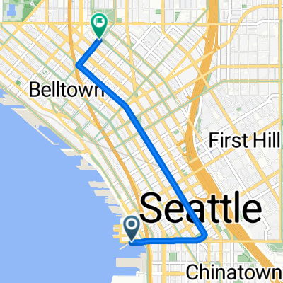
Vue d'ensemble
À propos du circuit
Cet itinéraire suit le chemin de moindre résistance autour du lac Union. Quelques points sur la carte ne suivent pas exactement la route que j'essayais d'entrer, mais c'est très proche, cela fonctionnera, et dans ces quelques cas, vous pourrez trouver des trajets plus directs. (Par exemple, on peut longer le "coin" sud-ouest du lac.)
Il y a très peu de dénivelé sur cet itinéraire. Le pont de l'université est une légère montée, et vous bénéficiez d'une descente gratuite après avoir traversé le pont Fremont. Le "sentier" longe vraiment le lac et évite Eastlake quand c'est possible, afin de prendre une montée plus facile et donner au cycliste quelques pâtés de maisons plats pour se 'reposer' entre les ascensions.
Cette balade prendra moins d'une demi-heure si vous maintenez un bon rythme.
- -:--
- Durée
- 11 km
- Distance
- 79 m
- Montée
- 77 m
- Descente
- ---
- Vit. moyenne
- 36 m
- Altitude max.
Qualité de l’itinéraire
Types de voies et surfaces le long de l’itinéraire
Types de routes
Route tranquille
2,5 km
(23 %)
Route
2,2 km
(20 %)
surfaces
Pavé
8,8 km
(80 %)
Asphalte
5,2 km
(47 %)
Béton
3,6 km
(33 %)
Indéfini
2,2 km
(20 %)
Continuer avec Bikemap
Utilise, modifie ou télécharge cet itinéraire vélo
Tu veux parcourir Circumnavigating Lake Union ou l’adapter à ton propre voyage ? Voici ce que tu peux faire avec cet itinéraire Bikemap :
Fonctionnalités gratuites
- Enregistre cet itinéraire comme favori ou dans une collection
- Copie et planifie ta propre version de cet itinéraire
- Synchronise ton itinéraire avec Garmin ou Wahoo
Fonctionnalités Premium
Essai gratuit de 3 jours, ou paiement unique. En savoir plus sur Bikemap Premium.
- Navigue sur cet itinéraire sur iOS et Android
- Exporter un fichier GPX / KML de cet itinéraire
- Crée ton impression personnalisée (essaie-la gratuitement)
- Télécharge cet itinéraire pour la navigation hors ligne
Découvre plus de fonctionnalités Premium.
Obtiens Bikemap PremiumDe notre communauté
Seattle : Autres itinéraires populaires qui commencent ici
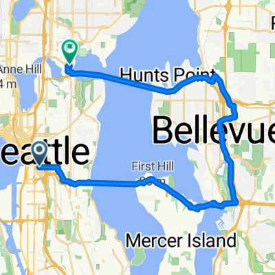
 To Bellevue and Back
- Distance
- 15,8 km
- Montée
- 265 m
- Descente
- 265 m
- Emplacement
- Seattle, Washington, États Unis
 Afternoon Commute
- Distance
- 4,2 km
- Montée
- 79 m
- Descente
- 112 m
- Emplacement
- Seattle, Washington, États Unis
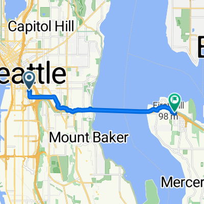
 E Hamlin St, Seattle to W Mercer Way, Mercer Island
- Distance
- 20,8 km
- Montée
- 298 m
- Descente
- 256 m
- Emplacement
- Seattle, Washington, États Unis
 East Harrison Street to East Mercer Street
- Distance
- 21 km
- Montée
- 271 m
- Descente
- 214 m
- Emplacement
- Seattle, Washington, États Unis
 Chinatown to UW via Mercer
- Distance
- 32,1 km
- Montée
- 357 m
- Descente
- 351 m
- Emplacement
- Seattle, Washington, États Unis
 5th Ave S, Seattle to 76th Ave SE, Mercer Island
- Distance
- 8,3 km
- Montée
- 98 m
- Descente
- 81 m
- Emplacement
- Seattle, Washington, États Unis
 Alaskan/Jackson ➡️ Central Cinema
- Distance
- 4,2 km
- Montée
- 133 m
- Descente
- 32 m
- Emplacement
- Seattle, Washington, États Unis
 Morning Commute 2
- Distance
- 3,2 km
- Montée
- 101 m
- Descente
- 64 m
- Emplacement
- Seattle, Washington, États Unis
Ouvre-la dans l’app