Sawmill Creek, Mississauga Loop - 10k
Un itinéraire vélo au départ de Mississauga, Ontario, Canada.
Vue d'ensemble
À propos du circuit
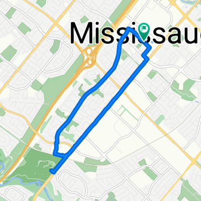
Un bel itinéraire récréatif à Erin Mills. Montée au début et descente à la fin. Faites-le dans le sens des aiguilles d'une montre en commençant par la moitié sud du circuit pour profiter du ruisseau qui descend. Entièrement sur des sentiers. Les passages du Erin Mills Parkway sont des tunnels de sentier sous le niveau de la rue. Quelques passages à niveau de rue secondaire. La partie résidentielle de la route est un sentier pavé et la partie du ruisseau est un chemin de terre.
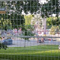
Vous pouvez amener vos vélos en voiture au parc Erindale et vous garer dans le parking là-bas. Un pont piétonnier traverse la rivière Credit — il peut être franchi à vélo lorsque le trafic piéton est léger. La partie Sawmill Creek est magnifique. Le sentier du ruisseau peut être humide au printemps et après une bonne pluie.
Les deux collines au début de l'itinéraire peuvent nécessiter de se démonter pour les cyclistes les plus occasionnels pour monter l'inclinaison.
Les cyclistes souhaitant prolonger leur balade peuvent le faire le long de la rivière Credit par le Culham Trail qui rejoint le parking du parc Erindale.
- -:--
- Durée
- 10 km
- Distance
- 76 m
- Montée
- 76 m
- Descente
- ---
- Vit. moyenne
- ---
- Altitude max.
Photos de l’itinéraire
Qualité de l’itinéraire
Types de voies et surfaces le long de l’itinéraire
Types de routes
Piste cyclable
7,2 km
(72 %)
Sentier
2,4 km
(24 %)
surfaces
Pavé
3,3 km
(33 %)
Non pavé
0,2 km
(2 %)
Asphalte
3,2 km
(32 %)
Sol
0,2 km
(2 %)
Continuer avec Bikemap
Utilise, modifie ou télécharge cet itinéraire vélo
Tu veux parcourir Sawmill Creek, Mississauga Loop - 10k ou l’adapter à ton propre voyage ? Voici ce que tu peux faire avec cet itinéraire Bikemap :
Fonctionnalités gratuites
- Enregistre cet itinéraire comme favori ou dans une collection
- Copie et planifie ta propre version de cet itinéraire
- Synchronise ton itinéraire avec Garmin ou Wahoo
Fonctionnalités Premium
Essai gratuit de 3 jours, ou paiement unique. En savoir plus sur Bikemap Premium.
- Navigue sur cet itinéraire sur iOS et Android
- Exporter un fichier GPX / KML de cet itinéraire
- Crée ton impression personnalisée (essaie-la gratuitement)
- Télécharge cet itinéraire pour la navigation hors ligne
Découvre plus de fonctionnalités Premium.
Obtiens Bikemap PremiumDe notre communauté
Mississauga : Autres itinéraires populaires qui commencent ici
 Violet Road 4449, Mississauga to Violet Road 4449, Mississauga
- Distance
- 11,9 km
- Montée
- 83 m
- Descente
- 52 m
- Emplacement
- Mississauga, Ontario, Canada
 Ninth Line
- Distance
- 10,3 km
- Montée
- 19 m
- Descente
- 20 m
- Emplacement
- Mississauga, Ontario, Canada
 Downtown Community Ride & Public Art Tour
- Distance
- 9 km
- Montée
- 129 m
- Descente
- 95 m
- Emplacement
- Mississauga, Ontario, Canada
 streetsville to gleennie
- Distance
- 50,6 km
- Montée
- 144 m
- Descente
- 233 m
- Emplacement
- Mississauga, Ontario, Canada
 waterfront Trail 0724
- Distance
- 2,3 km
- Montée
- 62 m
- Descente
- 62 m
- Emplacement
- Mississauga, Ontario, Canada
 10 Clarkson
- Distance
- 18,4 km
- Montée
- 42 m
- Descente
- 37 m
- Emplacement
- Mississauga, Ontario, Canada
 RiverGrove CC - Salmon Run Community Ride - 8km
- Distance
- 8,4 km
- Montée
- 139 m
- Descente
- 97 m
- Emplacement
- Mississauga, Ontario, Canada
 Mississauga Downtown Community Ride & Public Art Tour
- Distance
- 8,1 km
- Montée
- 41 m
- Descente
- 41 m
- Emplacement
- Mississauga, Ontario, Canada
Ouvre-la dans l’app


