

Colle Vert Enduro (Verres Aosta)
Un itinéraire vélo au départ de Verrès, Vallée d'Aoste, Italie.
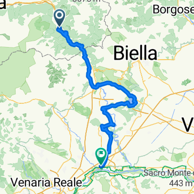
Vue d'ensemble
À propos du circuit
Section après Champurney incertaine
Parcours : (Verrès –) Omens – Champore – Colle Vert – Fornelle – Barmelongue – Avieil – Champurney – Prouve Ville – Arnad – Verrès
Description de la sortie :
La sortie commence à Omens, où l'on peut monter en voiture. Ensuite, on part directement dans la montée raide, d'abord quelques mètres sur l'asphalte, puis de nombreux virages en épingle sur un chemin en gravier, 630 mètres de dénivelé positif. Le Colle Vert est atteint lorsque l'on tourne à droite sur le chemin de gravier vers Fornelle. D'ailleurs, une belle vue sur le Cervin est toujours possible pendant la montée. La descente commence ensuite sans danger sur le chemin de gravier vers Fornelle. Juste après le dernier virage à droite avant les premières maisons, à gauche, commence le 2-Trail. Le sentier étroit serpente à travers la forêt raide, alternant virages en épingle avec des sections rapides et des passages scooter, tout cela très fluide mais nécessitant la concentration adéquate. On traverse une petite route, puis le sentier devient un peu plus accidenté jusqu'à atteindre le hameau d'Avieil. Ici, on tourne à gauche et on roule sur la petite route vers Champurney. La descente directe d'ici vers Arnad est un peu ennuyeuse. Plus excitant est le 3-Trail, qui bifurque rapidement à droite et serpente de façon complexe et fluide jusqu'aux maisons de Prouve Ville. Il longe la route principale puis revient à Verrès.
- -:--
- Durée
- 21,8 km
- Distance
- 1 024 m
- Montée
- 1 025 m
- Descente
- ---
- Vit. moyenne
- ---
- Altitude max.

Continuer avec Bikemap
Utilise, modifie ou télécharge cet itinéraire vélo
Tu veux parcourir Colle Vert Enduro (Verres Aosta) ou l’adapter à ton propre voyage ? Voici ce que tu peux faire avec cet itinéraire Bikemap :
Fonctionnalités gratuites
- Enregistre cet itinéraire comme favori ou dans une collection
- Copie et planifie ta propre version de cet itinéraire
- Synchronise ton itinéraire avec Garmin ou Wahoo
Fonctionnalités Premium
Essai gratuit de 3 jours, ou paiement unique. En savoir plus sur Bikemap Premium.
- Navigue sur cet itinéraire sur iOS et Android
- Exporter un fichier GPX / KML de cet itinéraire
- Crée ton impression personnalisée (essaie-la gratuitement)
- Télécharge cet itinéraire pour la navigation hors ligne
Découvre plus de fonctionnalités Premium.
Obtiens Bikemap PremiumDe notre communauté
Verrès : Autres itinéraires populaires qui commencent ici
 Verres-Ivrea.Viverone-Chivasso
- Distance
- 113,3 km
- Montée
- 441 m
- Descente
- 624 m
- Emplacement
- Verrès, Vallée d'Aoste, Italie
 champoluc antagnod lignod verres
- Distance
- 57,2 km
- Montée
- 1 371 m
- Descente
- 1 378 m
- Emplacement
- Verrès, Vallée d'Aoste, Italie
 Vall d'Ayas e Vall di Gressoney
- Distance
- 94,3 km
- Montée
- 2 267 m
- Descente
- 2 267 m
- Emplacement
- Verrès, Vallée d'Aoste, Italie
 Vall d'Ayas e Vall di Gressoney
- Distance
- 94,3 km
- Montée
- 2 251 m
- Descente
- 2 251 m
- Emplacement
- Verrès, Vallée d'Aoste, Italie
 Colle Vert Enduro (Verres Aosta)
- Distance
- 21,8 km
- Montée
- 1 024 m
- Descente
- 1 025 m
- Emplacement
- Verrès, Vallée d'Aoste, Italie
 Col d'Arlaz, Col Tsecore e Col de Joux
- Distance
- 61,2 km
- Montée
- 2 086 m
- Descente
- 2 086 m
- Emplacement
- Verrès, Vallée d'Aoste, Italie
 col Tze Core-col de Joux - ago.2010
- Distance
- 52 km
- Montée
- 1 694 m
- Descente
- 1 694 m
- Emplacement
- Verrès, Vallée d'Aoste, Italie
 Brusson > Champoluc > Saint Barthélémy
- Distance
- 140,8 km
- Montée
- 2 900 m
- Descente
- 2 909 m
- Emplacement
- Verrès, Vallée d'Aoste, Italie
Ouvre-la dans l’app