

St Ninian's Way- Girvan to Maybole
Un itinéraire vélo au départ de Girvan, Ecosse, Royaume-Uni.
Vue d'ensemble
À propos du circuit
Girvan to Maybole 24 km
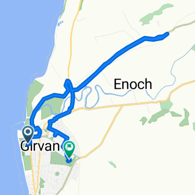
This 19th section of St Ninian’s Way starts at the centre of Girvan on the signposted Ayrshire Coastal Path. Go north along the coast to Dipple (6km) . Join the A77 briefly and then continue along the coast on ACP to Turnberry (3km). Continue north along coast, then turn east, through airport and go north to junction with A719 at Maidens (3 km). Go east along A719 to junction with minor road going south (1.5km). . Take minor road to T-junction with A77(2 km). Turn left and go north-east along the A77 To Kirkoswald (1 km). Visit Souter Johnnie’s Cottage. Continue along A 77 to junction with minor road going South (.5km). Go south along minor road for 100 m and then turn left across ford and proceed to road junction with A77 (3 km) . Go 500 m along A77, with Crossmraguel Abbey on your right, and leave the A77 onto a minor road, which continues alongside A77 to Carrick Academy((2km) , then take the A77 to Maybole centre and Town Hall (.5 km).
Coastal path,then into the Ayrshire hills.
Also part of the Whithorn Way - http://www.whithornway.org . courtesy of the WWSG where a detailed route description with grid references is available.
For a map overview of Part 1 and Part 2 of St Ninian’s Way please go to https://www.bikemap.net/en/route/3548129-st-ninians-way-carlisle-to-st-andrews-part-1-carlisle-to-whithorn/
St Ninian’s Way is one of the great pilgrim routes in Scotland to St Andrews - The Way of St Andrews - For other routes see http://www.thewayofstandrews.com
- -:--
- Durée
- 23,9 km
- Distance
- 206 m
- Montée
- 128 m
- Descente
- ---
- Vit. moyenne
- ---
- Altitude max.

Continuer avec Bikemap
Utilise, modifie ou télécharge cet itinéraire vélo
Tu veux parcourir St Ninian's Way- Girvan to Maybole ou l’adapter à ton propre voyage ? Voici ce que tu peux faire avec cet itinéraire Bikemap :
Fonctionnalités gratuites
- Enregistre cet itinéraire comme favori ou dans une collection
- Copie et planifie ta propre version de cet itinéraire
- Synchronise ton itinéraire avec Garmin ou Wahoo
Fonctionnalités Premium
Essai gratuit de 3 jours, ou paiement unique. En savoir plus sur Bikemap Premium.
- Navigue sur cet itinéraire sur iOS et Android
- Exporter un fichier GPX / KML de cet itinéraire
- Crée ton impression personnalisée (essaie-la gratuitement)
- Télécharge cet itinéraire pour la navigation hors ligne
Découvre plus de fonctionnalités Premium.
Obtiens Bikemap PremiumDe notre communauté
Girvan : Autres itinéraires populaires qui commencent ici
 Girvan and South Carrick Ward, Girvan to Girvan and South Carrick Ward, Girvan
- Distance
- 28,3 km
- Montée
- 339 m
- Descente
- 339 m
- Emplacement
- Girvan, Ecosse, Royaume-Uni
 Sophie and emma
- Distance
- 10,1 km
- Montée
- 230 m
- Descente
- 219 m
- Emplacement
- Girvan, Ecosse, Royaume-Uni
 Hervey Road 1 to The Clachan 36, Barr
- Distance
- 13,7 km
- Montée
- 288 m
- Descente
- 188 m
- Emplacement
- Girvan, Ecosse, Royaume-Uni
 Girvan and South Carrick Ward, Girvan to Girvan and South Carrick Ward, Girvan
- Distance
- 13,2 km
- Montée
- 187 m
- Descente
- 187 m
- Emplacement
- Girvan, Ecosse, Royaume-Uni
 ayrshire
- Distance
- 66,6 km
- Montée
- 500 m
- Descente
- 497 m
- Emplacement
- Girvan, Ecosse, Royaume-Uni
 11 Back Road, Girvan to 47 Main Street, Girvan
- Distance
- 23,9 km
- Montée
- 488 m
- Descente
- 496 m
- Emplacement
- Girvan, Ecosse, Royaume-Uni
 Barr / Pinmore Loop (above Girvan)
- Distance
- 27,9 km
- Montée
- 316 m
- Descente
- 317 m
- Emplacement
- Girvan, Ecosse, Royaume-Uni
 Old Daily - Maybole circuit
- Distance
- 58,7 km
- Montée
- 550 m
- Descente
- 552 m
- Emplacement
- Girvan, Ecosse, Royaume-Uni
Ouvre-la dans l’app