

Emscherkunst 2016 – Recklinghausen bis Castrop
Un itinéraire vélo au départ de Castrop-Rauxel, Rhénanie du Nord-Westphalie, Allemagne.
Vue d'ensemble
À propos du circuit
Emscherkunst 2016 – Recklinghausen (Stadthafen, Umspannwerk) bis Castrop (Wasserkreuz, Warten auf den Fluss)
- -:--
- Durée
- 14,4 km
- Distance
- 41 m
- Montée
- 45 m
- Descente
- ---
- Vit. moyenne
- ---
- Altitude max.
Points forts de l’itinéraire
Points d’intérêt le long de l’itinéraire
Point d'intérêt après 0 km
Observatorium: Warten auf den Fluss, 2010
Point d'intérêt après 2,9 km
Janet Cardiff & George Bures Miller: Forest (For as thousand years ...), 2012/2016
Point d'intérêt après 3,6 km
Tadashi Kawamata: Walkway and Tower, 2010
Point d'intérêt après 4,7 km
Möglicher Parkplatz für PKW
Point d'intérêt après 9,2 km
Bogomir Ecker: Reemrenreh (Kaum Gesang), 2010
Point d'intérêt après 13,4 km
Silke Wagner: Bergarbeiterproteste im Ruhrgebiet, 2010
Point d'intérêt après 14,1 km
Superflex: Waste Water Fountain, 2016
Point d'intérêt après 14,3 km
Roman Signer: Analyse, 2016
Continuer avec Bikemap
Utilise, modifie ou télécharge cet itinéraire vélo
Tu veux parcourir Emscherkunst 2016 – Recklinghausen bis Castrop ou l’adapter à ton propre voyage ? Voici ce que tu peux faire avec cet itinéraire Bikemap :
Fonctionnalités gratuites
- Enregistre cet itinéraire comme favori ou dans une collection
- Copie et planifie ta propre version de cet itinéraire
- Synchronise ton itinéraire avec Garmin ou Wahoo
Fonctionnalités Premium
Essai gratuit de 3 jours, ou paiement unique. En savoir plus sur Bikemap Premium.
- Navigue sur cet itinéraire sur iOS et Android
- Exporter un fichier GPX / KML de cet itinéraire
- Crée ton impression personnalisée (essaie-la gratuitement)
- Télécharge cet itinéraire pour la navigation hors ligne
Découvre plus de fonctionnalités Premium.
Obtiens Bikemap PremiumDe notre communauté
Castrop-Rauxel : Autres itinéraires populaires qui commencent ici
 CAS-DO
- Distance
- 28,1 km
- Montée
- 134 m
- Descente
- 136 m
- Emplacement
- Castrop-Rauxel, Rhénanie du Nord-Westphalie, Allemagne
 Henrichenburg - Emscherweg - Hochlarmark - am Kanal R10 wieder zurück ca. 25 km
- Distance
- 24,3 km
- Montée
- 42 m
- Descente
- 42 m
- Emplacement
- Castrop-Rauxel, Rhénanie du Nord-Westphalie, Allemagne
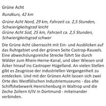 Grüne Acht Süd K25 3, Castrop-Rauxel nach Amselstraße, Castrop-Rauxel
- Distance
- 24,5 km
- Montée
- 142 m
- Descente
- 143 m
- Emplacement
- Castrop-Rauxel, Rhénanie du Nord-Westphalie, Allemagne
 DO-Bövinghausen-Zeche Waltrop - Lanstroper Ei - DO-Hafen - Tante Amanda - Zeche Zollern
- Distance
- 63 km
- Montée
- 186 m
- Descente
- 182 m
- Emplacement
- Castrop-Rauxel, Rhénanie du Nord-Westphalie, Allemagne
 Herne Erzbahntrasse 01
- Distance
- 37 km
- Montée
- 169 m
- Descente
- 168 m
- Emplacement
- Castrop-Rauxel, Rhénanie du Nord-Westphalie, Allemagne
 Abendrunde am Kanal
- Distance
- 33,1 km
- Montée
- 86 m
- Descente
- 88 m
- Emplacement
- Castrop-Rauxel, Rhénanie du Nord-Westphalie, Allemagne
 Obercastrop- Gysenberg Park- Obercastrop
- Distance
- 14 km
- Montée
- 108 m
- Descente
- 79 m
- Emplacement
- Castrop-Rauxel, Rhénanie du Nord-Westphalie, Allemagne
 Schlösser
- Distance
- 21,7 km
- Montée
- 193 m
- Descente
- 193 m
- Emplacement
- Castrop-Rauxel, Rhénanie du Nord-Westphalie, Allemagne
Ouvre-la dans l’app