

St Ninian's Way - Lochwinnoch to Paisley
Un itinéraire vélo au départ de Lochwinnoch, Ecosse, Royaume-Uni.
Vue d'ensemble
À propos du circuit
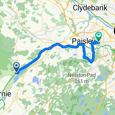
Lochwinnoch à Paisley
Ce 24ème tronçon de St Ninian’s Way suit un sentier balisé et la Route Nationale à Vélo 7 jusqu'à Paisley. Le point de départ est le sentier à côté du Castle Semple Loch qui mène à un pont au-dessus d'une autoroute (6 km). Puis continuez vers le nord le long du Black Cart Water jusqu'à un autre pont (2 km). Traversez le pont et continuez le long du chemin jusqu'à Elderslie (1,5 km), puis vers Sauce Hill, juste au sud de Paisley (3 km). Prenez ensuite la Causeyside Road sur 200 m, tournez à droite dans Gordon Street sur 100 m et traversez la rivière Clyde, sur Cotton Street jusqu'à l'abbaye de Paisley (300 m). Une option est de continuer sur Gauze Street et à l'intersection avec la cathédrale catholique de St Mirren.
Sentier panoramique et balisé
Fait aussi partie du Whithorn Way - http://www.whithornway.org . Avec l’aimable autorisation de la WWSG où une description détaillée de l'itinéraire avec des références de grille est disponible.
Pour une vue d'ensemble de la carte de la Partie 1 et de la Partie 2 de St Ninian’s Way, veuillez visiter https://www.bikemap.net/en/route/3548129-st-ninians-way-carlisle-to-st-andrews-part-1-carlisle-to-whithorn/
Le St Ninian’s Way est l'un des grands itinéraires de pèlerinage en Écosse vers St Andrews - Le Chemin de St Andrews - Pour d'autres itinéraires voir http://www.thewayofstandrews.com
- -:--
- Durée
- 15,9 km
- Distance
- 65 m
- Montée
- 85 m
- Descente
- ---
- Vit. moyenne
- ---
- Altitude max.

Qualité de l’itinéraire
Types de voies et surfaces le long de l’itinéraire
Types de routes
Piste cyclable
14,5 km
(91 %)
Route
0,2 km
(1 %)
surfaces
Pavé
14,5 km
(91 %)
Asphalte
14,5 km
(91 %)
Indéfini
1,4 km
(9 %)
Points forts de l’itinéraire
Points d’intérêt le long de l’itinéraire
Point d'intérêt après 15,8 km
St Mirin's Cathedral
Point d'intérêt après 15,8 km
Paisley Abbey
Continuer avec Bikemap
Utilise, modifie ou télécharge cet itinéraire vélo
Tu veux parcourir St Ninian's Way - Lochwinnoch to Paisley ou l’adapter à ton propre voyage ? Voici ce que tu peux faire avec cet itinéraire Bikemap :
Fonctionnalités gratuites
- Enregistre cet itinéraire comme favori ou dans une collection
- Copie et planifie ta propre version de cet itinéraire
- Synchronise ton itinéraire avec Garmin ou Wahoo
Fonctionnalités Premium
Essai gratuit de 3 jours, ou paiement unique. En savoir plus sur Bikemap Premium.
- Navigue sur cet itinéraire sur iOS et Android
- Exporter un fichier GPX / KML de cet itinéraire
- Crée ton impression personnalisée (essaie-la gratuitement)
- Télécharge cet itinéraire pour la navigation hors ligne
Découvre plus de fonctionnalités Premium.
Obtiens Bikemap PremiumDe notre communauté
Lochwinnoch : Autres itinéraires populaires qui commencent ici
 Lochwinnoch -
- Distance
- 23 km
- Montée
- 113 m
- Descente
- 147 m
- Emplacement
- Lochwinnoch, Ecosse, Royaume-Uni
 Barn Cottage, Kilbirnie Road, Lochwinnoch to 330 Byres Road, Glasgow
- Distance
- 37,6 km
- Montée
- 198 m
- Descente
- 216 m
- Emplacement
- Lochwinnoch, Ecosse, Royaume-Uni
 Harvey Square to Bathgo Avenue
- Distance
- 26,1 km
- Montée
- 113 m
- Descente
- 180 m
- Emplacement
- Lochwinnoch, Ecosse, Royaume-Uni
 Etape 21 : Lochwinnoch-Glasgow
- Distance
- 41,2 km
- Montée
- 186 m
- Descente
- 125 m
- Emplacement
- Lochwinnoch, Ecosse, Royaume-Uni
 East Lochhead, Kilbirnie Road, Lochwinnoch to 5 Marine Ct, Largs
- Distance
- 24,3 km
- Montée
- 425 m
- Descente
- 470 m
- Emplacement
- Lochwinnoch, Ecosse, Royaume-Uni
 Lochlip Road, Lochwinnoch to 78A South Beach, Troon
- Distance
- 41,4 km
- Montée
- 196 m
- Descente
- 226 m
- Emplacement
- Lochwinnoch, Ecosse, Royaume-Uni
 Church Street 17 to Kilbirnie Road
- Distance
- 3,9 km
- Montée
- 40 m
- Descente
- 13 m
- Emplacement
- Lochwinnoch, Ecosse, Royaume-Uni
 Barn Cottage, Kilbirnie Road, Lochwinnoch to Fairlie House, Main Road, Largs
- Distance
- 23,8 km
- Montée
- 435 m
- Descente
- 484 m
- Emplacement
- Lochwinnoch, Ecosse, Royaume-Uni
Ouvre-la dans l’app