

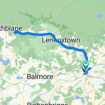
St Ninian's Way- Kirkintilloch to Falkirk
Un itinéraire vélo au départ de Kirkintilloch, Ecosse, Royaume-Uni.
Vue d'ensemble
À propos du circuit
This 27th section of St Ninian’s Way starts on the Forth and Clyde Canal tow path where it is joined by the John Muir Way from the north, and continues along JMW all the way to Falkirk, often parallel to the Antonine Wall, and switching to the Union Canal.
This is a long section but there are plenty of towns along the way where overnight accommodation can be found.
From Kirkintilloch proceed east along north bank of Forth and Clyde Canal on BR 754. After 100m the tow path is joined by the John Muir Way from the north. Proceed to Twechar (6 km). Follow JMW across bridge and up along Antonine Wall, over Croy Hill (4 km) to bridge over canal where JMW rejoins the canal tow path (2 km), then keep along JMW and tow path to Banknock (4 km) and then Bonnybridge (6 km). Continue on JMW across bridge and along Antonine Wall to Falkirk Wheel (3 km). Then go along JMW across Union Canal, and through woods and along paths to bridge (3km). Cross bridge and rejoin canal tow path to Falkirk High Street area (6 km).
A great experience - from tramping like a Roman legionary along the historic Antonine Wall to marvelling at modern and towering engineering marvel, the Falkirk Wheel, for canal navigation.
For more details and ordnance survey map of this route please go to
http://johnmuirway.org/route/kilsyth-falkirk
For a map overview of Part 1 and Part 2 of St Ninian’s Way please go to https://www.bikemap.net/en/route/3548129-st-ninians-way-carlisle-to-st-andrews-part-1-carlisle-to-whithorn/
St Ninian’s Way is one of the great pilgrim routes in Scotland to St Andrews - The Way of St Andrews - For other routes see http://www.thewayofstandrews.com
- -:--
- Durée
- 29,9 km
- Distance
- 136 m
- Montée
- 108 m
- Descente
- ---
- Vit. moyenne
- ---
- Altitude max.

Qualité de l’itinéraire
Types de voies et surfaces le long de l’itinéraire
Types de routes
Piste cyclable
22,4 km
(75 %)
Route forestière
2,1 km
(7 %)
surfaces
Pavé
19,7 km
(66 %)
Non pavé
1,1 km
(4 %)
Asphalte
19,1 km
(64 %)
Gravier
0,8 km
(3 %)
Points forts de l’itinéraire
Points d’intérêt le long de l’itinéraire
Point d'intérêt après 1,1 km
Joins John Muir Way
Point d'intérêt après 4,4 km
Roman Fort
Point d'intérêt après 7,4 km
Roman Fort
Point d'intérêt après 10,4 km
Roman Fort
Point d'intérêt après 23,1 km
Antonine Wall
Point d'intérêt après 25 km
Falkirk Wheel
Continuer avec Bikemap
Utilise, modifie ou télécharge cet itinéraire vélo
Tu veux parcourir St Ninian's Way- Kirkintilloch to Falkirk ou l’adapter à ton propre voyage ? Voici ce que tu peux faire avec cet itinéraire Bikemap :
Fonctionnalités gratuites
- Enregistre cet itinéraire comme favori ou dans une collection
- Copie et planifie ta propre version de cet itinéraire
- Synchronise ton itinéraire avec Garmin ou Wahoo
Fonctionnalités Premium
Essai gratuit de 3 jours, ou paiement unique. En savoir plus sur Bikemap Premium.
- Navigue sur cet itinéraire sur iOS et Android
- Exporter un fichier GPX / KML de cet itinéraire
- Crée ton impression personnalisée (essaie-la gratuitement)
- Télécharge cet itinéraire pour la navigation hors ligne
Découvre plus de fonctionnalités Premium.
Obtiens Bikemap PremiumDe notre communauté
Kirkintilloch : Autres itinéraires populaires qui commencent ici
 33–43 Alexander Place, Glasgow to 55 Bankhead Road, Glasgow
- Distance
- 9,4 km
- Montée
- 80 m
- Descente
- 78 m
- Emplacement
- Kirkintilloch, Ecosse, Royaume-Uni
 Anniversary 2
- Distance
- 59,2 km
- Montée
- 155 m
- Descente
- 172 m
- Emplacement
- Kirkintilloch, Ecosse, Royaume-Uni
 Relaxed route in Glasgow
- Distance
- 13,8 km
- Montée
- 54 m
- Descente
- 56 m
- Emplacement
- Kirkintilloch, Ecosse, Royaume-Uni
 55.939, -4.155 do 55.942, -4.153
- Distance
- 25,4 km
- Montée
- 253 m
- Descente
- 271 m
- Emplacement
- Kirkintilloch, Ecosse, Royaume-Uni
 Fellsview Avenue 50, Kirkintilloch to Fellsview Avenue 48, Kirkintilloch
- Distance
- 47,5 km
- Montée
- 441 m
- Descente
- 452 m
- Emplacement
- Kirkintilloch, Ecosse, Royaume-Uni
 ride through Glasgow
- Distance
- 27 km
- Montée
- 192 m
- Descente
- 159 m
- Emplacement
- Kirkintilloch, Ecosse, Royaume-Uni
 forth & Clyde canal
- Distance
- 16,8 km
- Montée
- 210 m
- Descente
- 132 m
- Emplacement
- Kirkintilloch, Ecosse, Royaume-Uni
 Fellsview Avenue 77, Kirkintilloch to Fellsview Avenue 44, Kirkintilloch
- Distance
- 58,9 km
- Montée
- 369 m
- Descente
- 374 m
- Emplacement
- Kirkintilloch, Ecosse, Royaume-Uni
Ouvre-la dans l’app