

Other side of Tallinn bike tour
Un itinéraire vélo au départ de Tallinn, Harju, Estonie.
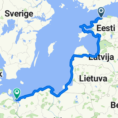
Vue d'ensemble
À propos du circuit
Aventure dans une jungle urbaine pleine d'architecture de l'Union soviétique et de zones de vie intéressantes.
- -:--
- Durée
- 14,3 km
- Distance
- 62 m
- Montée
- 63 m
- Descente
- ---
- Vit. moyenne
- ---
- Altitude max.
Qualité de l’itinéraire
Types de voies et surfaces le long de l’itinéraire
Types de routes
Zone piétonne
3,4 km
(24 %)
Route
3,3 km
(23 %)
surfaces
Pavé
11,3 km
(79 %)
Non pavé
0,4 km
(3 %)
Asphalte
10,9 km
(76 %)
Pavé (non défini)
0,4 km
(3 %)
Points forts de l’itinéraire
Points d’intérêt le long de l’itinéraire

Point d'intérêt après 1,7 km
PATAREI PRISON - Patarei was built by the order of Russian Emperor Nicholas I as a fortress, with the official name of Defence Barracks. The fortification complex was completed in 1840, but due to the changed warfare strategy it was never used for its intended purpose.

Point d'intérêt après 2,6 km
KALAMAJA PARK - Kalamaja was the location of the oldest cemetery in Tallinn, known as Kalamaja cemetery (Estonian: Kalamaja kalmistu, German: Fischermay Kirchhof) which was founded in the 15th or 16th century.The cemetery was flattened in 1964,during the second occupation of the Baltic states, by Soviet authorities who used the area of Kalamaja as a base for the Soviet Armed Forces.

Point d'intérêt après 3,8 km
ARSENA- The Arsenal M23 submachine gun (Estonian: Arsenali püstolkuulipilduja) (also known as Arsenal Tallinn) was an Estonian submachine gun from 1926 through 1935. These submachine guns were designed and produced in the Estonian military equipment factory "Arsenal" in Karjamaa, Tallinn, but production was not more than 600 units. The weapon was chambered for the 9x20 mm semi-rimmed Browning cartridge to be compatible with ammunition for the Browning FN M1903 pistol which had been adopted by the Estonian Army.

Point d'intérêt après 5 km
In addition to the gigantic main building, a number of wooden living quarters were built on Sitsi Street in the first years of the 20th century. In 1913, an Art Nouveau style schoolhouse was added to the ensemble. A small Orthodox Church that is operating to this day was also built in 1915. All this together forms the historically valuable Sitsi urban settlement.

Point d'intérêt après 6,8 km
The Kopli cemetery (German: Friedhof von Ziegelskoppel or Kirchhof von Ziegelskoppel; Estonian: Kopli kalmistu) was Estonia's largest Lutheran Baltic German cemetery, located in the suburb of Kopli in Tallinn. It contained thousands of graves of prominent citizens of Tallinn and stood from 1774 to shortly after World War II, when it was completely flattened and destroyed by the Soviet occupation authorities governing the country at the time.[1] The former cemetery is now a public park.[citation needed]

Point d'intérêt après 7,7 km
Stroomi beach is a child-friendly sandy swimming beach in northern Tallinn. Children can have fun in the playground, drive electric cars or jump on the trampoline. The beach also has areas for ball games, an open air gym, 2 outdoor cafes and an ice cream van. The beach has its own changing cabins, lockers, beach chair hire and shower. Stroomi beach is a popular barbecue and picnic place. In addition to beach facilities and playgrounds, it has lit bicycle tracks, sports fields and several cafés. Good to know: Beach patrol operates during the swimming season.

Point d'intérêt après 10,1 km
Church with a slender steeple amidst the low houses of the Pelgulinna region. The congregation was deprived of its church during the Soviet times. The church and the congregation house (architect Eugen Sacharias) now also provide room for a care centre for street children, a shelter, a children´s home, a crime victims advisory board.

Point d'intérêt après 11,5 km
Culture sector discovers and conquers forgotten spaces of the city. It seems that office is no longer just an office and our private lives and work are more and more connected. These tendencies are also expressed in urban space. The activity of Telliskivi Loomelinnak (Telliskivi Creative City) in Northern Tallinn has changed the former Baltic Railway factory area into a vibrant urban centre – there are 10 buildings on the territory with a total area of 25.000 m2 that now house a varied array of offices, cultural facilities, shops and bars. Something new seems to happen every week.
Continuer avec Bikemap
Utilise, modifie ou télécharge cet itinéraire vélo
Tu veux parcourir Other side of Tallinn bike tour ou l’adapter à ton propre voyage ? Voici ce que tu peux faire avec cet itinéraire Bikemap :
Fonctionnalités gratuites
- Enregistre cet itinéraire comme favori ou dans une collection
- Copie et planifie ta propre version de cet itinéraire
- Synchronise ton itinéraire avec Garmin ou Wahoo
Fonctionnalités Premium
Essai gratuit de 3 jours, ou paiement unique. En savoir plus sur Bikemap Premium.
- Navigue sur cet itinéraire sur iOS et Android
- Exporter un fichier GPX / KML de cet itinéraire
- Crée ton impression personnalisée (essaie-la gratuitement)
- Télécharge cet itinéraire pour la navigation hors ligne
Découvre plus de fonctionnalités Premium.
Obtiens Bikemap PremiumDe notre communauté
Tallinn : Autres itinéraires populaires qui commencent ici
 Vaida-Kohila-Saku (MNT)
- Distance
- 101,6 km
- Montée
- 289 m
- Descente
- 286 m
- Emplacement
- Tallinn, Harju, Estonie
 Route to Jagala Waterfall
- Distance
- 32,6 km
- Montée
- 72 m
- Descente
- 46 m
- Emplacement
- Tallinn, Harju, Estonie
 Talinn to Riga
- Distance
- 492,4 km
- Montée
- 206 m
- Descente
- 225 m
- Emplacement
- Tallinn, Harju, Estonie
 Tallin - Usedom
- Distance
- 1 967,9 km
- Montée
- 549 m
- Descente
- 548 m
- Emplacement
- Tallinn, Harju, Estonie
 Pirita-Lagedi-Peetri (GRV)
- Distance
- 53,4 km
- Montée
- 160 m
- Descente
- 161 m
- Emplacement
- Tallinn, Harju, Estonie
 Ümber Tallinna
- Distance
- 105,4 km
- Montée
- 150 m
- Descente
- 150 m
- Emplacement
- Tallinn, Harju, Estonie
 Jāņi
Jāņi- Distance
- 469,5 km
- Montée
- 368 m
- Descente
- 397 m
- Emplacement
- Tallinn, Harju, Estonie
 EV106 yhiss6it
- Distance
- 48,8 km
- Montée
- 163 m
- Descente
- 163 m
- Emplacement
- Tallinn, Harju, Estonie
Ouvre-la dans l’app