

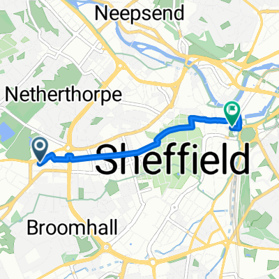
Crookesmoor - Rotherham hospital
Un itinéraire vélo au départ de Sheffield, Angleterre, Royaume-Uni.
Vue d'ensemble
À propos du circuit
Go down the hill from Crookesmoor road cross roads. Follow the road round to the right at the bottom of the hill. Turn left then go past tesco infrimary road on your right. Go over the road with the trams on. Its one way stay in the left hand lane but turn right onto penistone road. I normally stay on the road but you can go on the pavement as there's a bike path. Dont turn left to NGH but next left and you go along this road parallel to Penistone road to avoid the Shalesmoor roundabout. Come back onto the main road by tunring right at Cornish Street then carry on following the road round past Riverside pub and onto Derek Dooley way. Veer left onto Saville street and go past the 24 hour tesco. Carry on along this long road - you go past the old steel works. Theres quite a big roundabout with traffic lights that once you get the hang of the lanes isn't too bad but the first time I got off and walked it round. You want to go straigh over. Carry on to Meadwohall. You'll get to a pedestrian bridge to meadowhall (on your right at a pedestrian crossing). Go over this and then turn left onto the bike path. Carry on along this. It'll take you past a bit of road works and then you'll get to the tram stop at Meadowhall. Go over the bridge (walk over the tramlines then theres a bridge). At the bottom of the bridge you're onto the canal and follow the signs to Rotherham (left at the bottom). the signs are quite good from here. Once you get to the big football stadium in Rotherham carry on past it with it on your left. Turn right at the end of the road the stadium is on and you'll be ona road called main street (ignore the map bit here telling you to go in a loop back to main street as its trying to get you to go one way)with a club called Hedonism or something infront of you. Turn right and you should see a sign for Moorgate/Rothervalley park with a bike on it - basically follow these.( It will take you left up a steep one way road called Wilfred street) You need to end up on Moorgate road - keep cycling up this you'll go past somewhere called Woodside NHS but keep going as the hospital is furtehr along Moorgate road!
- -:--
- Durée
- 17,3 km
- Distance
- 90 m
- Montée
- 127 m
- Descente
- ---
- Vit. moyenne
- ---
- Altitude max.

Continuer avec Bikemap
Utilise, modifie ou télécharge cet itinéraire vélo
Tu veux parcourir Crookesmoor - Rotherham hospital ou l’adapter à ton propre voyage ? Voici ce que tu peux faire avec cet itinéraire Bikemap :
Fonctionnalités gratuites
- Enregistre cet itinéraire comme favori ou dans une collection
- Copie et planifie ta propre version de cet itinéraire
- Synchronise ton itinéraire avec Garmin ou Wahoo
Fonctionnalités Premium
Essai gratuit de 3 jours, ou paiement unique. En savoir plus sur Bikemap Premium.
- Navigue sur cet itinéraire sur iOS et Android
- Exporter un fichier GPX / KML de cet itinéraire
- Crée ton impression personnalisée (essaie-la gratuitement)
- Télécharge cet itinéraire pour la navigation hors ligne
Découvre plus de fonctionnalités Premium.
Obtiens Bikemap PremiumDe notre communauté
Sheffield : Autres itinéraires populaires qui commencent ici
 Views
Views- Distance
- 24,6 km
- Montée
- 329 m
- Descente
- 329 m
- Emplacement
- Sheffield, Angleterre, Royaume-Uni
 Octagon Centre Sheffield Return
- Distance
- 2,2 km
- Montée
- 0 m
- Descente
- 62 m
- Emplacement
- Sheffield, Angleterre, Royaume-Uni
 Urban Dash
- Distance
- 15,7 km
- Montée
- 180 m
- Descente
- 183 m
- Emplacement
- Sheffield, Angleterre, Royaume-Uni
 Sheffield to Hadfield Low Traffic Gravel
- Distance
- 61,9 km
- Montée
- 548 m
- Descente
- 428 m
- Emplacement
- Sheffield, Angleterre, Royaume-Uni
 Octagon Centre Sheffield
- Distance
- 2,2 km
- Montée
- 66 m
- Descente
- 4 m
- Emplacement
- Sheffield, Angleterre, Royaume-Uni
 Brad field- Bamford loop
- Distance
- 41 km
- Montée
- 0 m
- Descente
- 0 m
- Emplacement
- Sheffield, Angleterre, Royaume-Uni
 Claremont Spring Meander, 3 April 2011
- Distance
- 97,2 km
- Montée
- 1 034 m
- Descente
- 1 037 m
- Emplacement
- Sheffield, Angleterre, Royaume-Uni
 20/04/2020
- Distance
- 48,9 km
- Montée
- 672 m
- Descente
- 672 m
- Emplacement
- Sheffield, Angleterre, Royaume-Uni
Ouvre-la dans l’app