

Säntis Classic
Un itinéraire vélo au départ de Weinfelden, Thurgau, Switzerland.
Vue d'ensemble
À propos du circuit
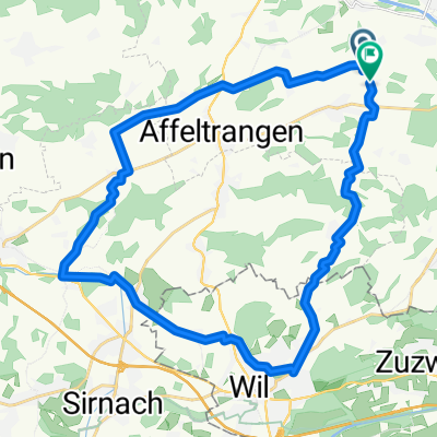
This loop follows the route of the Säntis Classic, an annual challenge that attracts almost 2000 cyclists.
Leaving Weinfelden in Canton Thurgau, the road rises gently in the countryside before descending to Wil. This is where you enter Canton St. Gallen.
The route undulates as it enters the hilly Toggenburg region. At Ebnat-Kappel, you continue to follow the Thur river upstream along the valley’s flank, taking a charming little road that meanders amid the farms away from the traffic.
The main ascent starts at Neu Sankt Johann and consists of a number of ramps (gradient: 7-8%) through the meadows interspersed with level sections. The pass itself is reached at alt. 1278m and offers views of the Säntis (alt. 2502m), the main peak in the regions which can be accessed via aerial cableway. In fine weather, this peak offers views not only of Switzerland, but also of Germany, Austria, Liechtenstein and France!
A rapid descent leads to Urnäsch, after which a series of back roads bring you to Herisau, the capital of Canton Appenzell Ausserrhoden. The 40km return leg to Weinfelden is largely downhill.
- -:--
- Durée
- 123,8 km
- Distance
- 1 204 m
- Montée
- 1 204 m
- Descente
- ---
- Vit. moyenne
- ---
- Altitude max.

Qualité de l’itinéraire
Types de voies et surfaces le long de l’itinéraire
Types de routes
Route
38,7 km
(31 %)
Route fréquentée
37,8 km
(30 %)
surfaces
Pavé
93 km
(75 %)
Non pavé
0,1 km
(<1 %)
Asphalte
81,6 km
(66 %)
Pavé (non défini)
11,4 km
(9 %)
Continuer avec Bikemap
Utilise, modifie ou télécharge cet itinéraire vélo
Tu veux parcourir Säntis Classic ou l’adapter à ton propre voyage ? Voici ce que tu peux faire avec cet itinéraire Bikemap :
Fonctionnalités gratuites
- Enregistre cet itinéraire comme favori ou dans une collection
- Copie et planifie ta propre version de cet itinéraire
- Divise-le en étapes pour créer un tour sur plusieurs jours
- Synchronise ton itinéraire avec Garmin ou Wahoo
Fonctionnalités Premium
Essai gratuit de 3 jours, ou paiement unique. En savoir plus sur Bikemap Premium.
- Navigue sur cet itinéraire sur iOS et Android
- Exporter un fichier GPX / KML de cet itinéraire
- Crée ton impression personnalisée (essaie-la gratuitement)
- Télécharge cet itinéraire pour la navigation hors ligne
Découvre plus de fonctionnalités Premium.
Obtiens Bikemap PremiumDe notre communauté
Weinfelden : Autres itinéraires populaires qui commencent ici
 Relaxed route in Weinfelden
- Distance
- 25,4 km
- Montée
- 104 m
- Descente
- 104 m
- Emplacement
- Weinfelden, Thurgau, Switzerland
 Neugutstrasse 2, Weinfelden nach Amriswilerstrasse 54, Weinfelden
- Distance
- 47,5 km
- Montée
- 609 m
- Descente
- 615 m
- Emplacement
- Weinfelden, Thurgau, Switzerland
 Route in Bussnang
- Distance
- 30,5 km
- Montée
- 494 m
- Descente
- 492 m
- Emplacement
- Weinfelden, Thurgau, Switzerland
 Frauenfeld-Weinfelden
- Distance
- 33,6 km
- Montée
- 80 m
- Descente
- 80 m
- Emplacement
- Weinfelden, Thurgau, Switzerland
 thurathlon 2014 velostrecke
- Distance
- 47,4 km
- Montée
- 495 m
- Descente
- 495 m
- Emplacement
- Weinfelden, Thurgau, Switzerland
 schloss hagenwil
- Distance
- 18,6 km
- Montée
- 159 m
- Descente
- 147 m
- Emplacement
- Weinfelden, Thurgau, Switzerland
 thurathlon 2013 bike
- Distance
- 29,3 km
- Montée
- 350 m
- Descente
- 309 m
- Emplacement
- Weinfelden, Thurgau, Switzerland
 Ausfahrt durch Bussnang
- Distance
- 21,1 km
- Montée
- 253 m
- Descente
- 254 m
- Emplacement
- Weinfelden, Thurgau, Switzerland
Ouvre-la dans l’app