

Biking - Kormacit - Blue Trail
Un itinéraire vélo au départ de Lápithos, Kyrenia, Chypre.
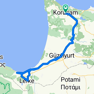
Vue d'ensemble
À propos du circuit
The BLUE TRAIL is the connection to the the village of AKDENIZ. First part is flat through the field with a short steep downhill passage at the valley. The dirt track in the forest is wide as a highway and experienced bikers will speed up. Halfway there is the possible extension to the Caretta Restaurant at the beach befor turning back following the edge of the valley. - MEDIUM
- -:--
- Durée
- 27,8 km
- Distance
- 284 m
- Montée
- 284 m
- Descente
- ---
- Vit. moyenne
- ---
- Altitude max.

Qualité de l’itinéraire
Types de voies et surfaces le long de l’itinéraire
Types de routes
Route forestière
22,6 km
(81 %)
Route tranquille
4,5 km
(16 %)
surfaces
Pavé
6 km
(22 %)
Non pavé
15,6 km
(56 %)
Non pavé (non défini)
15,6 km
(56 %)
Pavé (non défini)
4,7 km
(17 %)
Points forts de l’itinéraire
Points d’intérêt le long de l’itinéraire
Point d'intérêt après 11,8 km
Akdeniz pine forest
Point d'intérêt après 15,5 km
Caretta Caretta restaurant
Point d'intérêt après 15,6 km
Akdeniz turtle beach
Continuer avec Bikemap
Utilise, modifie ou télécharge cet itinéraire vélo
Tu veux parcourir Biking - Kormacit - Blue Trail ou l’adapter à ton propre voyage ? Voici ce que tu peux faire avec cet itinéraire Bikemap :
Fonctionnalités gratuites
- Enregistre cet itinéraire comme favori ou dans une collection
- Copie et planifie ta propre version de cet itinéraire
- Synchronise ton itinéraire avec Garmin ou Wahoo
Fonctionnalités Premium
Essai gratuit de 3 jours, ou paiement unique. En savoir plus sur Bikemap Premium.
- Navigue sur cet itinéraire sur iOS et Android
- Exporter un fichier GPX / KML de cet itinéraire
- Crée ton impression personnalisée (essaie-la gratuitement)
- Télécharge cet itinéraire pour la navigation hors ligne
Découvre plus de fonctionnalités Premium.
Obtiens Bikemap PremiumDe notre communauté
Lápithos : Autres itinéraires populaires qui commencent ici
 Auto - Kormacit - Güzelyurt - Kormacit
- Distance
- 46,4 km
- Montée
- 447 m
- Descente
- 447 m
- Emplacement
- Lápithos, Kyrenia, Chypre
 Auto - Kormacit - West cosat - Yesilirmak
- Distance
- 59,7 km
- Montée
- 542 m
- Descente
- 689 m
- Emplacement
- Lápithos, Kyrenia, Chypre
 Auto - Kormacit - West Coast
- Distance
- 90,1 km
- Montée
- 624 m
- Descente
- 624 m
- Emplacement
- Lápithos, Kyrenia, Chypre
 Bike - Karşıyaka - St Hilarion - Girne
- Distance
- 48,7 km
- Montée
- 821 m
- Descente
- 1 504 m
- Emplacement
- Lápithos, Kyrenia, Chypre
 Auto - Kormacit - Antiphonitis - Girne
- Distance
- 121,8 km
- Montée
- 1 768 m
- Descente
- 1 929 m
- Emplacement
- Lápithos, Kyrenia, Chypre
 Bike - Kormacit - Sadrazamköy short trail
- Distance
- 32,2 km
- Montée
- 446 m
- Descente
- 447 m
- Emplacement
- Lápithos, Kyrenia, Chypre
 Cypro4PRP-Alsanak-Kaplica
- Distance
- 68,9 km
- Montée
- 331 m
- Descente
- 331 m
- Emplacement
- Lápithos, Kyrenia, Chypre
 Auto - Kormacit - Kalkanli - Guzelyurt - Sadrazamkoy - Kormacit
- Distance
- 70,4 km
- Montée
- 719 m
- Descente
- 719 m
- Emplacement
- Lápithos, Kyrenia, Chypre
Ouvre-la dans l’app