Kazimierz Dolny (Poland)
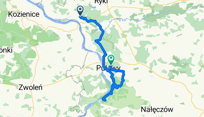
Un itinéraire vélo au départ de Dęblin, voïvodie de Lublin, Pologne.
Vue d'ensemble
À propos du circuit
Depuis Dęblin, la route suit la Greenways Amber Route, qui est très bien balisée au début. Cependant, je l'ai perdue quelques kilomètres avant Puławy, c’est pourquoi j’ai parcouru cette partie sur une route très fréquentée le long du fleuve Vistule. De Puławy à Kazimierz Dolny, j’ai essayé de suivre un sentier de randonnée noir, mais à de nombreux endroits je ne pouvais pas le trouver. Il vaut la peine d’avoir un VTT pour cette partie du voyage, car elle emprunte des routes forestières, souvent étroites et à travers des ravins parfois assez raides. À Kazimierz Dolny, il vaut la peine de passer un peu de temps à se promener dans cette ville intéressante. Sur le chemin du retour, je roulais sur la digue le long de la Vistule, puis j’ai monté où là encore, par endroits, je ne pouvais pas voir le sentier. Si vous prévoyez de rentrer en train, souvenez-vous que la gare s’appelle Puławy Miasto, pas simplement Puławy – celle-ci est une gare de fret. Google Maps m’a mené à la gare de fret et ensuite j’ai raté le train de 3 minutes ;)
- -:--
- Durée
- 77,3 km
- Distance
- 319 m
- Montée
- 291 m
- Descente
- ---
- Vit. moyenne
- ---
- Altitude max.
Qualité de l’itinéraire
Types de voies et surfaces le long de l’itinéraire
Types de routes
Route tranquille
18,5 km
(24 %)
Route
15,5 km
(20 %)
surfaces
Pavé
36,3 km
(47 %)
Non pavé
6,2 km
(8 %)
Asphalte
33,2 km
(43 %)
Sol
5,4 km
(7 %)
Continuer avec Bikemap
Utilise, modifie ou télécharge cet itinéraire vélo
Tu veux parcourir Kazimierz Dolny (Poland) ou l’adapter à ton propre voyage ? Voici ce que tu peux faire avec cet itinéraire Bikemap :
Fonctionnalités gratuites
- Enregistre cet itinéraire comme favori ou dans une collection
- Copie et planifie ta propre version de cet itinéraire
- Synchronise ton itinéraire avec Garmin ou Wahoo
Fonctionnalités Premium
Essai gratuit de 3 jours, ou paiement unique. En savoir plus sur Bikemap Premium.
- Navigue sur cet itinéraire sur iOS et Android
- Exporter un fichier GPX / KML de cet itinéraire
- Crée ton impression personnalisée (essaie-la gratuitement)
- Télécharge cet itinéraire pour la navigation hors ligne
Découvre plus de fonctionnalités Premium.
Obtiens Bikemap PremiumDe notre communauté
Dęblin : Autres itinéraires populaires qui commencent ici
 Dęblin1
- Distance
- 53,2 km
- Montée
- 36 m
- Descente
- 37 m
- Emplacement
- Dęblin, voïvodie de Lublin, Pologne
 Generała pilota Józefa Kowalskiego 19, Dęblin do Generała pilota Józefa Kowalskiego 19, Dęblin
- Distance
- 29,7 km
- Montée
- 44 m
- Descente
- 45 m
- Emplacement
- Dęblin, voïvodie de Lublin, Pologne
 Dęblin - Kazimierz - Wąwolnica - Dęblin
- Distance
- 108,6 km
- Montée
- 301 m
- Descente
- 302 m
- Emplacement
- Dęblin, voïvodie de Lublin, Pologne
 Wisła Rzeką Strategiczną
- Distance
- 207,2 km
- Montée
- 251 m
- Descente
- 253 m
- Emplacement
- Dęblin, voïvodie de Lublin, Pologne
 Pętla 30 km zachodnia
- Distance
- 30,7 km
- Montée
- 20 m
- Descente
- 19 m
- Emplacement
- Dęblin, voïvodie de Lublin, Pologne
 mała pętla Dęblin
- Distance
- 23,7 km
- Montée
- 44 m
- Descente
- 49 m
- Emplacement
- Dęblin, voïvodie de Lublin, Pologne
 debln pulawy
- Distance
- 47,6 km
- Montée
- 40 m
- Descente
- 37 m
- Emplacement
- Dęblin, voïvodie de Lublin, Pologne
 15 Pułku Piechoty Wilków, Dęblin do Stężycka 43, Dęblin
- Distance
- 14,1 km
- Montée
- 23 m
- Descente
- 23 m
- Emplacement
- Dęblin, voïvodie de Lublin, Pologne
Ouvre-la dans l’app


