

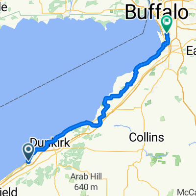
Lake Erie State Park to Kennerdell
Un itinéraire vélo au départ de Brocton, New York, États Unis.
Vue d'ensemble
À propos du circuit
- -:--
- Durée
- 187,1 km
- Distance
- 800 m
- Montée
- 708 m
- Descente
- ---
- Vit. moyenne
- ---
- Altitude max.

Qualité de l’itinéraire
Types de voies et surfaces le long de l’itinéraire
Types de routes
Piste cyclable
51,4 km
(27 %)
Route tranquille
48,6 km
(26 %)
surfaces
Pavé
107,5 km
(57 %)
Non pavé
19,5 km
(10 %)
Asphalte
100,2 km
(54 %)
Non pavé (non défini)
15 km
(8 %)
Points forts de l’itinéraire
Points d’intérêt le long de l’itinéraire
Point d'intérêt après 118,3 km
Drake Museum
Point d'intérêt après 120,7 km
Boughton
Point d'intérêt après 124,4 km
Miller Farm
Point d'intérêt après 126,6 km
Shaffer Farm
Point d'intérêt après 129,8 km
Pioneer
Point d'intérêt après 130,9 km
Funkville
Point d'intérêt après 132,9 km
Petroleum Center
Point d'intérêt après 134,7 km
Columbia Farm
Point d'intérêt après 137,4 km
Rynd Farm Train Station
Point d'intérêt après 140,2 km
At the south end of the Waitz Rd is the McClintock #1 historic site. Here you can see the world's oldest continuously-producing oil well. It was drilled with muscle power in 1861 and has produced continuously since then. This is a shallow, stripper well; this sort of well is often independently owned and produces only a few barrels of oil a day, but together such wells generate 30% of American oil. The well (now owned by the Commonwealth of Pennsylvania) yields only about 50 barrels a year, but it does still produce. If you are really fortunate, it may be running when you go there, and you can appreciate the light sweet order of the oil. The site has parking, benches, and interpretive signs.
Point d'intérêt après 172,6 km
Indian God Rock
Continuer avec Bikemap
Utilise, modifie ou télécharge cet itinéraire vélo
Tu veux parcourir Lake Erie State Park to Kennerdell ou l’adapter à ton propre voyage ? Voici ce que tu peux faire avec cet itinéraire Bikemap :
Fonctionnalités gratuites
- Enregistre cet itinéraire comme favori ou dans une collection
- Copie et planifie ta propre version de cet itinéraire
- Divise-le en étapes pour créer un tour sur plusieurs jours
- Synchronise ton itinéraire avec Garmin ou Wahoo
Fonctionnalités Premium
Essai gratuit de 3 jours, ou paiement unique. En savoir plus sur Bikemap Premium.
- Navigue sur cet itinéraire sur iOS et Android
- Exporter un fichier GPX / KML de cet itinéraire
- Crée ton impression personnalisée (essaie-la gratuitement)
- Télécharge cet itinéraire pour la navigation hors ligne
Découvre plus de fonctionnalités Premium.
Obtiens Bikemap PremiumDe notre communauté
Brocton : Autres itinéraires populaires qui commencent ici
 7912–7984 Thayer Rd, Portland to Pratt Ave, Chautauqua
- Distance
- 18,7 km
- Montée
- 149 m
- Descente
- 162 m
- Emplacement
- Brocton, New York, États Unis
 7912–7984 Thayer Rd, Portland to Massey Ave, Chautauqua
- Distance
- 18,3 km
- Montée
- 149 m
- Descente
- 154 m
- Emplacement
- Brocton, New York, États Unis
 6426–6436 NY-5, Portland to 8246 E Lake Rd, Westfield
- Distance
- 12,4 km
- Montée
- 32 m
- Descente
- 42 m
- Emplacement
- Brocton, New York, États Unis
 7912–7984 Thayer Rd, Portland to 1–5 Massey Ave, Chautauqua
- Distance
- 18,4 km
- Montée
- 141 m
- Descente
- 146 m
- Emplacement
- Brocton, New York, États Unis
 7912–7984 Thayer Rd, Portland to 38 Miller Ave, Chautauqua
- Distance
- 18,4 km
- Montée
- 579 m
- Descente
- 584 m
- Emplacement
- Brocton, New York, États Unis
 7996 Thayer Rd, Portland to 21 Waugh Ave, Chautauqua
- Distance
- 18,6 km
- Montée
- 157 m
- Descente
- 169 m
- Emplacement
- Brocton, New York, États Unis
 Brocton - Lackawanna
- Distance
- 89,1 km
- Montée
- 393 m
- Descente
- 399 m
- Emplacement
- Brocton, New York, États Unis
 7441 N Main St, Stockton to 4886–4966 Stockton-Brocton Rd, Stockton
- Distance
- 3,1 km
- Montée
- 52 m
- Descente
- 48 m
- Emplacement
- Brocton, New York, États Unis
Ouvre-la dans l’app