

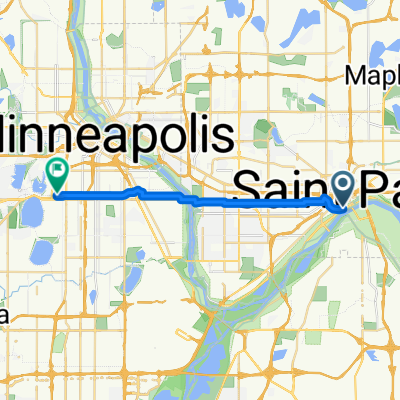
B2B00192 55102>55404viaShepherdRd/MissBlvd/WRiverPkwy/MidtwnGrnway
Un itinéraire vélo au départ de Saint Paul, Minnesota, États Unis.
Vue d'ensemble
À propos du circuit
Cet itinéraire est décidément plus long mais beaucoup plus intéressant et rapide. Il y a très peu d'arrêts comparé à un itinéraire à travers la ville. Prenez Shepherd Road West le long du fleuve Mississippi. Vous pouvez soit rouler sur la piste cyclable soit sur la route. Suivez Shepherd Rd. jusqu'à 35E jusqu'à ce qu'elle devienne East Mississippi River Blvd. Continuez sur East Mississippi en passant devant l'usine Ford. Passez sous le pont Ford Pkwy. et faites immédiatement un virage serré à droite pour rejoindre Ford Pkwy. et traversez le Mississippi sur le pont Ford. Juste à la fin du pont, il y a un chemin à droite qui vous conduira à West River Pkwy. Suivez West River Pkwy. soit sur la route soit sur la piste cyclable. Passez sous Lake Street et continuez. À E.27th Street, il y a un chemin qui monte vers le Midtown Greenway Bike Trail. Prenez le sentier cyclable vers l'ouest. À Hiawatha Avenue, vous pouvez soit continuer tout droit et traverser au feu, soit emprunter la piste cyclable. (Très cool la nuit avec des lumières bleues). Continuez sur la Greenway jusqu'à ce que vous atteigniez Chicago Avenue. Sortez par les escaliers vers la rue et allez vers le nord sur Chicago jusqu'à 26th Street et votre destination.
- -:--
- Durée
- 21,8 km
- Distance
- 131 m
- Montée
- 86 m
- Descente
- ---
- Vit. moyenne
- 258 m
- Altitude max.
Qualité de l’itinéraire
Types de voies et surfaces le long de l’itinéraire
Types de routes
Piste cyclable
16,8 km
(77 %)
Route
3,9 km
(18 %)
surfaces
Pavé
12,9 km
(59 %)
Asphalte
11,6 km
(53 %)
Béton
0,9 km
(4 %)
Points forts de l’itinéraire
Points d’intérêt le long de l’itinéraire
Point d'intérêt après 18,9 km
At this point you can continue across Hiawatha to E. 28th Street with the traffic signals or continue on the bike path to the north and over the Martin Sabo bridge.
Continuer avec Bikemap
Utilise, modifie ou télécharge cet itinéraire vélo
Tu veux parcourir B2B00192 55102>55404viaShepherdRd/MissBlvd/WRiverPkwy/MidtwnGrnway ou l’adapter à ton propre voyage ? Voici ce que tu peux faire avec cet itinéraire Bikemap :
Fonctionnalités gratuites
- Enregistre cet itinéraire comme favori ou dans une collection
- Copie et planifie ta propre version de cet itinéraire
- Synchronise ton itinéraire avec Garmin ou Wahoo
Fonctionnalités Premium
Essai gratuit de 3 jours, ou paiement unique. En savoir plus sur Bikemap Premium.
- Navigue sur cet itinéraire sur iOS et Android
- Exporter un fichier GPX / KML de cet itinéraire
- Crée ton impression personnalisée (essaie-la gratuitement)
- Télécharge cet itinéraire pour la navigation hors ligne
Découvre plus de fonctionnalités Premium.
Obtiens Bikemap PremiumDe notre communauté
Saint Paul : Autres itinéraires populaires qui commencent ici
 Way to Church
- Distance
- 13,2 km
- Montée
- 54 m
- Descente
- 37 m
- Emplacement
- Saint Paul, Minnesota, États Unis
 To the River Center
- Distance
- 17,1 km
- Montée
- 117 m
- Descente
- 90 m
- Emplacement
- Saint Paul, Minnesota, États Unis
 B2B00418 55117>55123 via Cedar, Wabasha, Lexington, Pilot Knob Rd
- Distance
- 20,8 km
- Montée
- 161 m
- Descente
- 156 m
- Emplacement
- Saint Paul, Minnesota, États Unis
 B2B00192 55102>55404viaShepherdRd/MissBlvd/WRiverPkwy/MidtwnGrnway
- Distance
- 21,8 km
- Montée
- 131 m
- Descente
- 86 m
- Emplacement
- Saint Paul, Minnesota, États Unis
 B2B00062 55106 - 55075 via Concord, NURT
- Distance
- 9,5 km
- Montée
- 80 m
- Descente
- 110 m
- Emplacement
- Saint Paul, Minnesota, États Unis
 Jackson Street to East 7th Street
- Distance
- 1,6 km
- Montée
- 36 m
- Descente
- 0 m
- Emplacement
- Saint Paul, Minnesota, États Unis
 B2B00629 55102 < 55402 via Summit, River Road, West bank, Downtown
- Distance
- 15,5 km
- Montée
- 82 m
- Descente
- 94 m
- Emplacement
- Saint Paul, Minnesota, États Unis
 Gateway State Trail
- Distance
- 30 km
- Montée
- 115 m
- Descente
- 69 m
- Emplacement
- Saint Paul, Minnesota, États Unis
Ouvre-la dans l’app