

B2B00191 55115>55401viaRandolph/MissBlvd/LkStBridge/WRiverPkwy/WashAv
Un itinéraire vélo au départ de Mendota Heights, Minnesota, États Unis.
Vue d'ensemble
À propos du circuit
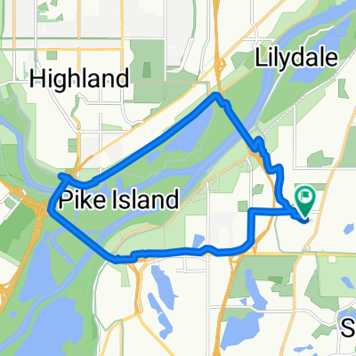
Allez vers l'ouest sur Randolph jusqu'à Mississippi River Blvd. Il y a une piste cyclable ou la route. Tournez à droite et continuez sur Miss. Blvd jusqu'à ce que vous atteigniez le Lake Street Bridge. Traversez le Lake Street Bridge du côté nord du pont. Après avoir traversé le pont, tournez à droite et prenez West River Pkwy. Piste cyclable ou route. Suivez W. River Pkwy. sous le Franklin Bridge en descendant la colline le long du Mississippi River jusqu'à ce que vous atteigniez S. 4th Street. (Une fois que le pont 35W rouvrira, vous continuerez sur West River Parkway jusqu'à atteindre le Hennepin Avenue Bridge. À Hennepin, prenez une rampe pour vélos jusqu'à Hennepin Avenue et allez vers le sud pendant 4 pâtés de maisons jusqu'à 300 Nicollet Mall.) Tournez à gauche et montez la colline jusqu'à la University of Minnesota West Bank.
À 19th Avenue, tournez à droite et allez à Washington Ave. S. Tournez à gauche et suivez Washington Avenue vers l'ouest jusqu'à ce que vous atteigniez Nicollet Mall. Tournez à gauche d'un pâté de maisons vers 300 Nicollet Mall.
- -:--
- Durée
- 11,6 km
- Distance
- 97 m
- Montée
- 109 m
- Descente
- ---
- Vit. moyenne
- 271 m
- Altitude max.
Qualité de l’itinéraire
Types de voies et surfaces le long de l’itinéraire
Types de routes
Route tranquille
3,9 km
(34 %)
Route
3,8 km
(33 %)
surfaces
Pavé
10,4 km
(90 %)
Asphalte
8,4 km
(73 %)
Béton
1,3 km
(11 %)
Points forts de l’itinéraire
Points d’intérêt le long de l’itinéraire
Point d'intérêt après 8,2 km
Once the 35W bridge is re-opened you would continue on W.River Parkway until you reach Hennepin Avenue. Go up the bike ramp to Hennepin and go south 4 blocks to 300 Nicollet Mall/Library.
Continuer avec Bikemap
Utilise, modifie ou télécharge cet itinéraire vélo
Tu veux parcourir B2B00191 55115>55401viaRandolph/MissBlvd/LkStBridge/WRiverPkwy/WashAv ou l’adapter à ton propre voyage ? Voici ce que tu peux faire avec cet itinéraire Bikemap :
Fonctionnalités gratuites
- Enregistre cet itinéraire comme favori ou dans une collection
- Copie et planifie ta propre version de cet itinéraire
- Synchronise ton itinéraire avec Garmin ou Wahoo
Fonctionnalités Premium
Essai gratuit de 3 jours, ou paiement unique. En savoir plus sur Bikemap Premium.
- Navigue sur cet itinéraire sur iOS et Android
- Exporter un fichier GPX / KML de cet itinéraire
- Crée ton impression personnalisée (essaie-la gratuitement)
- Télécharge cet itinéraire pour la navigation hors ligne
Découvre plus de fonctionnalités Premium.
Obtiens Bikemap PremiumDe notre communauté
Mendota Heights : Autres itinéraires populaires qui commencent ici
 Big Rivers, Pilot Knob, Acadia, Valley Park, ...
- Distance
- 13,3 km
- Montée
- 206 m
- Descente
- 206 m
- Emplacement
- Mendota Heights, Minnesota, États Unis
 Fort Snelling Loop
- Distance
- 33,8 km
- Montée
- 162 m
- Descente
- 164 m
- Emplacement
- Mendota Heights, Minnesota, États Unis
 B2B 55116 > 55106 via Summit Ave, Kellogg Blvd E
- Distance
- 14,3 km
- Montée
- 40 m
- Descente
- 63 m
- Emplacement
- Mendota Heights, Minnesota, États Unis
 Snail-like route in Mendota Heights
- Distance
- 14 km
- Montée
- 325 m
- Descente
- 325 m
- Emplacement
- Mendota Heights, Minnesota, États Unis
 South Minnehaha Drive 4935-4925, Minneapolis to South Minnehaha Drive, Minneapolis
- Distance
- 39,9 km
- Montée
- 10 m
- Descente
- 3 m
- Emplacement
- Mendota Heights, Minnesota, États Unis
 Mendota to Calhoun
- Distance
- 22 km
- Montée
- 171 m
- Descente
- 132 m
- Emplacement
- Mendota Heights, Minnesota, États Unis
 B2B00914 55116>55435 via Mend Brg, 494 bike brg, 73rd
- Distance
- 22,6 km
- Montée
- 141 m
- Descente
- 132 m
- Emplacement
- Mendota Heights, Minnesota, États Unis
 Mendota Heights-South St.Paul
- Distance
- 35,7 km
- Montée
- 218 m
- Descente
- 218 m
- Emplacement
- Mendota Heights, Minnesota, États Unis
Ouvre-la dans l’app