

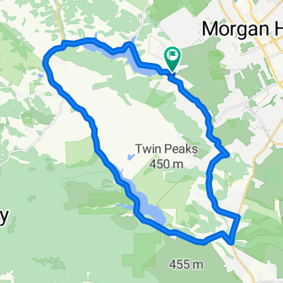
Coyote Valley by bike - Oct 21, 2017
Un itinéraire vélo au départ de Morgan Hill, Californie, États Unis.
Vue d'ensemble
À propos du circuit
Explore the Coyote Valley region by bicycle on a flat 21-mile loop. We'll visit the Coyote Valley Open Space Preserve, bike south and then back north across the valley floor, hop on the Coyote Creek Trail at Coyote Creek Golf Drive to the Anderson Lake Visitor Center, bike up to Northern Coyote Valley along the Coyote Creek Trail, and wave as we pass by Spina Farms (it'll be pumpkin season so it'll probably be too busy to stop there for long). Together we'll learn more about the history, wildlife, water, and agricultural story of this area. Bring your bike, a helmet, sun protection, 1-2 liters of water, and a bag lunch. You may want to bring cash or card to buy something at the Spina Farm Stand. Speakers will include Deb Kramer with Keep Coyote Creek Beautiful and our Executive Director Megan Medeiros. Cohosted by Keep Coyote Creek Beautiful, Greenbelt Alliance, and Committee for Green Foothills. Space is limited, RSVP today.
- -:--
- Durée
- 34,1 km
- Distance
- 71 m
- Montée
- 71 m
- Descente
- ---
- Vit. moyenne
- ---
- Altitude max.

Qualité de l’itinéraire
Types de voies et surfaces le long de l’itinéraire
Types de routes
Piste cyclable
10,9 km
(32 %)
Route tranquille
7,2 km
(21 %)
surfaces
Pavé
29 km
(85 %)
Non pavé
1,4 km
(4 %)
Asphalte
16,7 km
(49 %)
Pavé (non défini)
12,3 km
(36 %)
Continuer avec Bikemap
Utilise, modifie ou télécharge cet itinéraire vélo
Tu veux parcourir Coyote Valley by bike - Oct 21, 2017 ou l’adapter à ton propre voyage ? Voici ce que tu peux faire avec cet itinéraire Bikemap :
Fonctionnalités gratuites
- Enregistre cet itinéraire comme favori ou dans une collection
- Copie et planifie ta propre version de cet itinéraire
- Synchronise ton itinéraire avec Garmin ou Wahoo
Fonctionnalités Premium
Essai gratuit de 3 jours, ou paiement unique. En savoir plus sur Bikemap Premium.
- Navigue sur cet itinéraire sur iOS et Android
- Exporter un fichier GPX / KML de cet itinéraire
- Crée ton impression personnalisée (essaie-la gratuitement)
- Télécharge cet itinéraire pour la navigation hors ligne
Découvre plus de fonctionnalités Premium.
Obtiens Bikemap PremiumDe notre communauté
Morgan Hill : Autres itinéraires populaires qui commencent ici
 test
test- Distance
- 2,5 km
- Montée
- 17 m
- Descente
- 13 m
- Emplacement
- Morgan Hill, Californie, États Unis
 Steady ride in Morgan Hill
- Distance
- 21,2 km
- Montée
- 84 m
- Descente
- 84 m
- Emplacement
- Morgan Hill, Californie, États Unis
 East Dunne Avenue
- Distance
- 13,7 km
- Montée
- 287 m
- Descente
- 289 m
- Emplacement
- Morgan Hill, Californie, États Unis
 Uvas / Chesbro Loop
- Distance
- 25,8 km
- Montée
- 299 m
- Descente
- 299 m
- Emplacement
- Morgan Hill, Californie, États Unis
 Coyote Creek Trail: Anderson Lake - Hellyer Velodrome
- Distance
- 25,7 km
- Montée
- 18 m
- Descente
- 90 m
- Emplacement
- Morgan Hill, Californie, États Unis
 Morgan Hill Cycling
- Distance
- 23,6 km
- Montée
- 141 m
- Descente
- 144 m
- Emplacement
- Morgan Hill, Californie, États Unis
 Depot Street 17540, Morgan Hill to Williamsburg Way 715, Gilroy
- Distance
- 17,8 km
- Montée
- 36 m
- Descente
- 81 m
- Emplacement
- Morgan Hill, Californie, États Unis
 keith ride
- Distance
- 32,9 km
- Montée
- 312 m
- Descente
- 278 m
- Emplacement
- Morgan Hill, Californie, États Unis
Ouvre-la dans l’app