

Bike Centre to Somewhere Else
Un itinéraire vélo au départ de Llandegla, Pays de Galles, Royaume-Uni.
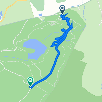
Vue d'ensemble
À propos du circuit
- -:--
- Durée
- 16,6 km
- Distance
- 420 m
- Montée
- 499 m
- Descente
- ---
- Vit. moyenne
- ---
- Altitude max.
Qualité de l’itinéraire
Types de voies et surfaces le long de l’itinéraire
Types de routes
Route tranquille
5,2 km
(31 %)
Sentier
3,5 km
(21 %)
surfaces
Pavé
0,7 km
(4 %)
Non pavé
0,3 km
(2 %)
Asphalte
0,7 km
(4 %)
Non pavé (non défini)
0,2 km
(1 %)
Points forts de l’itinéraire
Points d’intérêt le long de l’itinéraire
Point d'intérêt après 3,2 km
Waymarker should be for offas dyke. Should have an acorn on? Might not though ;-)
Point d'intérêt après 5,2 km
Go through the garden, turn right onto road. Then after houses bear left into field and follow path
Point d'intérêt après 6,1 km
Walk down grass verge, path crosses main road and goes up between houses.
Point d'intérêt après 6,9 km
Jim & Claires old house - say hello.
Point d'intérêt après 6,9 km
follow wall of churchyard, go down path in between church and old vicarage past water works. Don't keep on the tarmac road
Point d'intérêt après 8,4 km
Cross tarmac road onto gravel drive
Point d'intérêt après 9,4 km
Go over stile into field, just look for next sile. Goes up quite steep through fields
Point d'intérêt après 10,8 km
Bear right of tarmac road, but go to the left of the trees over stile towards the big mast. Dont go to the right of the trees towards the fisheries.
Point d'intérêt après 11,6 km
Steep Grass bank
Point d'intérêt après 11,7 km
At top of grass bank, bear right and go over stile
Point d'intérêt après 12,2 km
Tree & Steps
Point d'intérêt après 12,4 km
The old piggeries
Point d'intérêt après 15,1 km
The Raven
Point d'intérêt après 15,6 km
The Chapel - Jim & Claires other old house.
Continuer avec Bikemap
Utilise, modifie ou télécharge cet itinéraire vélo
Tu veux parcourir Bike Centre to Somewhere Else ou l’adapter à ton propre voyage ? Voici ce que tu peux faire avec cet itinéraire Bikemap :
Fonctionnalités gratuites
- Enregistre cet itinéraire comme favori ou dans une collection
- Copie et planifie ta propre version de cet itinéraire
- Synchronise ton itinéraire avec Garmin ou Wahoo
Fonctionnalités Premium
Essai gratuit de 3 jours, ou paiement unique. En savoir plus sur Bikemap Premium.
- Navigue sur cet itinéraire sur iOS et Android
- Exporter un fichier GPX / KML de cet itinéraire
- Crée ton impression personnalisée (essaie-la gratuitement)
- Télécharge cet itinéraire pour la navigation hors ligne
Découvre plus de fonctionnalités Premium.
Obtiens Bikemap PremiumDe notre communauté
Llandegla : Autres itinéraires populaires qui commencent ici
 UK - COED LLANDEGLA FOREST (niebieska)
- Distance
- 11,5 km
- Montée
- 196 m
- Descente
- 187 m
- Emplacement
- Llandegla, Pays de Galles, Royaume-Uni
 Bike Centre to Somewhere Else
- Distance
- 16,6 km
- Montée
- 420 m
- Descente
- 499 m
- Emplacement
- Llandegla, Pays de Galles, Royaume-Uni
 Recording from 13 February 09:01
- Distance
- 12,2 km
- Montée
- 208 m
- Descente
- 213 m
- Emplacement
- Llandegla, Pays de Galles, Royaume-Uni
 llandegla red and black Recording from 12 September 10:06 AM
- Distance
- 20,7 km
- Montée
- 339 m
- Descente
- 339 m
- Emplacement
- Llandegla, Pays de Galles, Royaume-Uni
 Steady ride
- Distance
- 3 km
- Montée
- 93 m
- Descente
- 27 m
- Emplacement
- Llandegla, Pays de Galles, Royaume-Uni
 The Retreat, Horseshoe Pass, Llangollen to Damson Cottage, Barton Road, Malpas
- Distance
- 34,2 km
- Montée
- 225 m
- Descente
- 601 m
- Emplacement
- Llandegla, Pays de Galles, Royaume-Uni
 UK - COED LLANDEGLA FOREST (czerwona)
- Distance
- 17,3 km
- Montée
- 361 m
- Descente
- 352 m
- Emplacement
- Llandegla, Pays de Galles, Royaume-Uni
 Mark Lloyd Mini Mega
- Distance
- 131,1 km
- Montée
- 1 301 m
- Descente
- 1 301 m
- Emplacement
- Llandegla, Pays de Galles, Royaume-Uni
Ouvre-la dans l’app