

B2B00276 55125>55112viaRadio/Inwood/Ideal/OlsonLk/Demont/Gatewy/Water/CtyE/Cent/VadLk/N.Owasso/Vict/CtyE
Un itinéraire vélo au départ de Woodbury, Minnesota, États Unis.
Vue d'ensemble
À propos du circuit
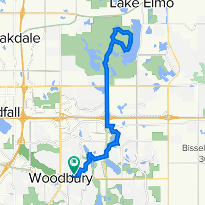
Take Radio Drive north where it becomes Inwood Avenue. Continue on Inwood until you reach Stillwater Blvd (6). Turn left on Stillwater Blvd to Ideal Avenue North. Ideal becomes Olson Lake Trail. Follow Olson Lake Trail around the lake to 50th St. N. Turn right. The road curves to the left and becomes Demontreville Trail N. Follow Demontreville Trail around the lake until you reach Highlands Trail North. Turn left up the hill to Hytrail Av. N and turn left. Follow around until you reach the bike path on your left next to a parking lot. Take this trail to the Gateway Trail. It goes through a little forest and suddenly comes out on the Gateway. Turn right on the Gateway and go through the tunnel under Highway 36. Just past the tunnel turn to the left off the trail to a hairpin turn up to a gravel parking lot. Follow the road (60th St.N) out to Hilton Trail. Turn right on Hilton Trail and turn left at the next intersection, 62nd St. North. Take 62nd to Warner Avenue. Take Warner Avenue to 75th St. N/Stillwater Road. Turn left and follow Stillwater Road through Mahtomedi until you reach Wildwood Road/244. Turn left and continue on Wildwood/244 past Wildwood Pond and up the hill where the road become County Road E. Follow County Road E passing White Bear Avenue, Highway 61, 35E. At Centerville Road turn left. Follow Centerville Road. At the next intersection Centerville becomes Vadnais Blvd. Go straight ahead on Vadnais Blvd. around Lake Vadnais. The road curves around the lake through a forest and through the lake. Up the hill is Rice Street. Turn left at Rice Street and cross over 694. At North Owasso Blvd. turn right. Follow North Owasso past Lake Owasso on your left and continue around the lake until you reach Victoria. Turn right on Victoria Street. Follow Victoria around until you reach County Road E West. Turn left and continue on County Road E to your destination.
- -:--
- Durée
- 33,1 km
- Distance
- 124 m
- Montée
- 150 m
- Descente
- ---
- Vit. moyenne
- 315 m
- Altitude max.
Qualité de l’itinéraire
Types de voies et surfaces le long de l’itinéraire
Types de routes
Route
9 km
(27 %)
Route tranquille
8,2 km
(25 %)
surfaces
Pavé
18,3 km
(55 %)
Asphalte
16,4 km
(49 %)
Pavé (non défini)
1,7 km
(5 %)
Continuer avec Bikemap
Utilise, modifie ou télécharge cet itinéraire vélo
Tu veux parcourir B2B00276 55125>55112viaRadio/Inwood/Ideal/OlsonLk/Demont/Gatewy/Water/CtyE/Cent/VadLk/N.Owasso/Vict/CtyE ou l’adapter à ton propre voyage ? Voici ce que tu peux faire avec cet itinéraire Bikemap :
Fonctionnalités gratuites
- Enregistre cet itinéraire comme favori ou dans une collection
- Copie et planifie ta propre version de cet itinéraire
- Synchronise ton itinéraire avec Garmin ou Wahoo
Fonctionnalités Premium
Essai gratuit de 3 jours, ou paiement unique. En savoir plus sur Bikemap Premium.
- Navigue sur cet itinéraire sur iOS et Android
- Exporter un fichier GPX / KML de cet itinéraire
- Crée ton impression personnalisée (essaie-la gratuitement)
- Télécharge cet itinéraire pour la navigation hors ligne
Découvre plus de fonctionnalités Premium.
Obtiens Bikemap PremiumDe notre communauté
Woodbury : Autres itinéraires populaires qui commencent ici
 10870 Ashley Ln, Woodbury to 10869 Ashley Ln, Woodbury
- Distance
- 28,9 km
- Montée
- 178 m
- Descente
- 177 m
- Emplacement
- Woodbury, Minnesota, États Unis
 Lake Elmo Ride
- Distance
- 24,1 km
- Montée
- 113 m
- Descente
- 113 m
- Emplacement
- Woodbury, Minnesota, États Unis
 B2B00248 55125>55112 viaRadio/Inwood/Ideal/OlsonLk/Demontr/WarnerRd/Lake/BaldEag/H2/Centv/CtyJ
- Distance
- 43,7 km
- Montée
- 134 m
- Descente
- 164 m
- Emplacement
- Woodbury, Minnesota, États Unis
 B2B00288 55125>55344 via Mndt Hght Rd, 494, 86th St
- Distance
- 46,8 km
- Montée
- 248 m
- Descente
- 283 m
- Emplacement
- Woodbury, Minnesota, États Unis
 Neighborhood loop
- Distance
- 19,5 km
- Montée
- 114 m
- Descente
- 113 m
- Emplacement
- Woodbury, Minnesota, États Unis
 1208 St Johns Dr, Woodbury to 1208 St Johns Dr, Woodbury
- Distance
- 8 km
- Montée
- 26 m
- Descente
- 28 m
- Emplacement
- Woodbury, Minnesota, États Unis
 Afton Ride
- Distance
- 51,2 km
- Montée
- 290 m
- Descente
- 304 m
- Emplacement
- Woodbury, Minnesota, États Unis
 B2B00915 55125>55115 viaLakeRd./CenturyAv/HudsonBlvd/Helmo/Ideal/Olson/Demontr/Hilton
- Distance
- 20,8 km
- Montée
- 115 m
- Descente
- 104 m
- Emplacement
- Woodbury, Minnesota, États Unis
Ouvre-la dans l’app