

Matadown - Valli del Natisone - Italy
Un itinéraire vélo au départ de Kobarid, Kobarid, Slovénie.
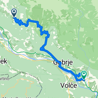
Vue d'ensemble
À propos du circuit
Il tracciato della Matadown parte dalla cima del monte Matajur a 1641 mt di altezza per arrivare a Sorzento in comune di San Pietro al Natisone dopo circa 12 km e 1400 mt. di dislivello negativo. La traccia è dedicata ai biker più esperti con biciclette da enduro ed è molto impegna- tiva. Nel 2017 è stato dichiarato uno dei trail naturali più belli d’Europa. La traccia parte dalla cima del monte Matajur dove è posta la Chiesetta del Redentore. Per rag- giungere la cima, si prende il sentiero che parte dal Rifu- gio Pelizzo; ristoro facilmente raggiungibile percorrendo la strada asfaltata che sale da Savogna. Dalla cima ci si dirige verso il Rifugio Dom e si svolta a destra verso il laghetto sottostante. Da qua si prosegue sulla traccia principale in direzione Passo di Glevizza. Si attraversa la strada e si prosegue lungo il sentiero sempre dritti sulla traccia principale che ci porterà sulla strada bianca che sempre in discesa conduce a Mezzana. Sotto il paese si svolta a sinistra sulla strada bianca che si percorre fino
a trovare le indicazioni che ci porteranno a Sorzento su un bellissimo sentiero. Da qui lungo la pista ciclabile si arriva a San Pietro al Natisone. È sconsigliata la percor- renza dei sentieri in condizioni di fango per motivi di sicu- rezza e per evitare l’erosione dei trail.
The Matadown track starts from the top of Mount Matajur, at 1641 mt and arrives to Sorzento, under the municipal- ity of San Pietro al Natisone, after about 12 km and 1400 mt descent. This challengingg trail its dedicated to expert cyclists of enduro. In 2017 it’s been nominated one of the most beautiful natural tracks in Europe. The trail starts from the top of Mount Matajur. To reach the top take the path from Rifugio Pelizzo (situated at the end of the paved road that goes up from Savogna). Head towards Rifugio Dom and turn right towards the pond below. From here continue on the main track towards Passo di Glevizza. Cross the road and continue straight on the main track, it will lead you to the white road that goes downhill to Mezzana. After the village turn left onto the white road and follow it until you nd the signs that will lead you to Sorzento by a beautiful path. From here along the cycle path you get to San Pietro al Natisone. It is not recom- mended the use of the track in mud conditions for security reasons and in order to prevent any damages to the trail.
- -:--
- Durée
- 11,9 km
- Distance
- 24 m
- Montée
- 1 344 m
- Descente
- ---
- Vit. moyenne
- ---
- Altitude max.

Continuer avec Bikemap
Utilise, modifie ou télécharge cet itinéraire vélo
Tu veux parcourir Matadown - Valli del Natisone - Italy ou l’adapter à ton propre voyage ? Voici ce que tu peux faire avec cet itinéraire Bikemap :
Fonctionnalités gratuites
- Enregistre cet itinéraire comme favori ou dans une collection
- Copie et planifie ta propre version de cet itinéraire
- Synchronise ton itinéraire avec Garmin ou Wahoo
Fonctionnalités Premium
Essai gratuit de 3 jours, ou paiement unique. En savoir plus sur Bikemap Premium.
- Navigue sur cet itinéraire sur iOS et Android
- Exporter un fichier GPX / KML de cet itinéraire
- Crée ton impression personnalisée (essaie-la gratuitement)
- Télécharge cet itinéraire pour la navigation hors ligne
Découvre plus de fonctionnalités Premium.
Obtiens Bikemap PremiumDe notre communauté
Kobarid : Autres itinéraires populaires qui commencent ici
 Slov - Trnovo
- Distance
- 35,8 km
- Montée
- 1 218 m
- Descente
- 1 218 m
- Emplacement
- Kobarid, Kobarid, Slovénie
 MTB Slowenien Soca Tour 14
- Distance
- 23,2 km
- Montée
- 1 215 m
- Descente
- 1 222 m
- Emplacement
- Kobarid, Kobarid, Slovénie
 MTB Slowenien Soca Tour 17
- Distance
- 42,2 km
- Montée
- 1 304 m
- Descente
- 1 307 m
- Emplacement
- Kobarid, Kobarid, Slovénie
 Kobarid -> Bovec
- Distance
- 23,1 km
- Montée
- 776 m
- Descente
- 568 m
- Emplacement
- Kobarid, Kobarid, Slovénie
 Ob Nadiži
- Distance
- 43,8 km
- Montée
- 719 m
- Descente
- 719 m
- Emplacement
- Kobarid, Kobarid, Slovénie
 Untitled route
- Distance
- 48,6 km
- Montée
- 859 m
- Descente
- 1 996 m
- Emplacement
- Kobarid, Kobarid, Slovénie
 Breginjski krog (ob Nadiži)
- Distance
- 26,9 km
- Montée
- 554 m
- Descente
- 563 m
- Emplacement
- Kobarid, Kobarid, Slovénie
 Alpe-Adria Trail 4-5
- Distance
- 24 km
- Montée
- 901 m
- Descente
- 1 302 m
- Emplacement
- Kobarid, Kobarid, Slovénie
Ouvre-la dans l’app