

Linderhof Ride
Un itinéraire vélo au départ de Ettal, Bavière, Allemagne.
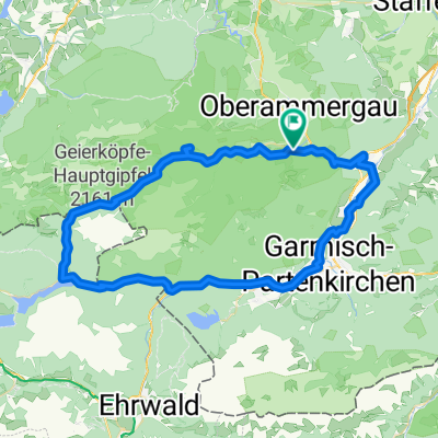
Vue d'ensemble
À propos du circuit
This is our Linderhof ride to the back gate of the castle. Recommend that you go early to avoid pedestrian walkers along forrest route and tourists at Linderhof.
- -:--
- Durée
- 24,2 km
- Distance
- 346 m
- Montée
- 343 m
- Descente
- ---
- Vit. moyenne
- ---
- Altitude max.
Points forts de l’itinéraire
Points d’intérêt le long de l’itinéraire
Point d'intérêt après 2,5 km
Here you make a left onto main highway, then take first right off highway. This will take you to the base of the mountain -- a nice varried terrrain.
Point d'intérêt après 6,1 km
2 choices here: Stay on gravel road and enter Linderhof at the top back gate - or turn left and head to Linderhof via Grasswang on the highway (easier).
Point d'intérêt après 10,2 km
Back gate entrance to Linderhof Castle!
Point d'intérêt après 11,7 km
A great reason to do the back hill - this is some of the best applestrudel we have had! (at the restaurant, off tourist season).
Continuer avec Bikemap
Utilise, modifie ou télécharge cet itinéraire vélo
Tu veux parcourir Linderhof Ride ou l’adapter à ton propre voyage ? Voici ce que tu peux faire avec cet itinéraire Bikemap :
Fonctionnalités gratuites
- Enregistre cet itinéraire comme favori ou dans une collection
- Copie et planifie ta propre version de cet itinéraire
- Synchronise ton itinéraire avec Garmin ou Wahoo
Fonctionnalités Premium
Essai gratuit de 3 jours, ou paiement unique. En savoir plus sur Bikemap Premium.
- Navigue sur cet itinéraire sur iOS et Android
- Exporter un fichier GPX / KML de cet itinéraire
- Crée ton impression personnalisée (essaie-la gratuitement)
- Télécharge cet itinéraire pour la navigation hors ligne
Découvre plus de fonctionnalités Premium.
Obtiens Bikemap PremiumDe notre communauté
Ettal : Autres itinéraires populaires qui commencent ici
 Ueber den Baeckenalmsattel zur Kenzenhuette
- Distance
- 59 km
- Montée
- 1 005 m
- Descente
- 1 004 m
- Emplacement
- Ettal, Bavière, Allemagne
 Ammer-Amper-Radweg
- Distance
- 190,7 km
- Montée
- 1 181 m
- Descente
- 1 582 m
- Emplacement
- Ettal, Bavière, Allemagne
 GA-PA horní cesta Čtvrtek
- Distance
- 53,9 km
- Montée
- 706 m
- Descente
- 735 m
- Emplacement
- Ettal, Bavière, Allemagne
 Garmisch-Partenkirchen
- Distance
- 67,7 km
- Montée
- 518 m
- Descente
- 517 m
- Emplacement
- Ettal, Bavière, Allemagne
 5) Ettal - Schwangau
- Distance
- 51,6 km
- Montée
- 447 m
- Descente
- 518 m
- Emplacement
- Ettal, Bavière, Allemagne
 Ettal-Wallgau-Bayrischzell-Kössen-Bad Reichenhall
- Distance
- 206,8 km
- Montée
- 1 424 m
- Descente
- 1 828 m
- Emplacement
- Ettal, Bavière, Allemagne
 Ettal - Ersterbergalm
- Distance
- 65 km
- Montée
- 1 278 m
- Descente
- 1 277 m
- Emplacement
- Ettal, Bavière, Allemagne
 Ettal - Ennigalm - Brunnenkopf
- Distance
- 64,2 km
- Montée
- 1 691 m
- Descente
- 1 695 m
- Emplacement
- Ettal, Bavière, Allemagne
Ouvre-la dans l’app