

Tour de Winooski
Un itinéraire vélo au départ de Winooski, Vermont, États Unis.
Vue d'ensemble
À propos du circuit
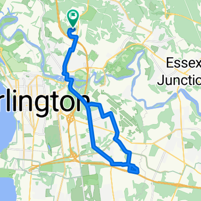
Le Tour de Winooski est une visite guidée à vélo proposée qui commence au Intervale Center. Ce centre d'agriculture communautaire est une ressource pour la production alimentaire localement cultivée et localement exploitée dans la région de Burlington, et se trouve à proximité des signes d'histoire géologique à l'arrêt suivant de la visite, Salmon Hole. Cette zone naturelle sur la rivière Winooski est un habitat important pour les poissons ripaires et montre son histoire géologique à travers les affleurements de dolomites qui l'abritent. La prochaine étape de la visite à vélo est l'usine Ben & Jerry's à Waterbury, VT. C'est une usine de production alimentaire locale qui est aimée par de nombreux habitants du Vermont et des personnes du monde entier. Avant que les cyclistes n'atteignent Waterbury, ils passeront devant le mont Mansfield, qui est le sommet le plus élevé du Vermont. Le prochain arrêt de la tournée est la Hubbard Tower à Montpelier. Les cyclistes peuvent gravir la tour d'observation et observer la géologie du bassin versant du Winooski à travers les vues des Green Mountains qui les entourent. S'ils sont fatigués, les cyclistes peuvent passer la nuit dans l'un des nombreux bed and breakfasts locaux à Montpelier. Le matin, les cyclistes suivront la tournée vers Barre. Ils peuvent faire des courses et réfléchir à la géologie chez Granite City Grocery, la coopérative alimentaire à Barre. À ce stade de la tournée à vélo, il est temps de faire demi-tour. Les cyclistes suivront le parcours sur un long chemin de retour à Burlington, où ils pourront déguster des plats locaux dans une variété de restaurants et se reposer à l'auberge de Burlington.
- -:--
- Durée
- 165,6 km
- Distance
- 549 m
- Montée
- 525 m
- Descente
- ---
- Vit. moyenne
- ---
- Altitude max.

Qualité de l’itinéraire
Types de voies et surfaces le long de l’itinéraire
Types de routes
Route
69,5 km
(42 %)
Route tranquille
28,2 km
(17 %)
surfaces
Pavé
124,2 km
(75 %)
Non pavé
36,4 km
(22 %)
Asphalte
120,9 km
(73 %)
Gravier
31,5 km
(19 %)
Continuer avec Bikemap
Utilise, modifie ou télécharge cet itinéraire vélo
Tu veux parcourir Tour de Winooski ou l’adapter à ton propre voyage ? Voici ce que tu peux faire avec cet itinéraire Bikemap :
Fonctionnalités gratuites
- Enregistre cet itinéraire comme favori ou dans une collection
- Copie et planifie ta propre version de cet itinéraire
- Divise-le en étapes pour créer un tour sur plusieurs jours
- Synchronise ton itinéraire avec Garmin ou Wahoo
Fonctionnalités Premium
Essai gratuit de 3 jours, ou paiement unique. En savoir plus sur Bikemap Premium.
- Navigue sur cet itinéraire sur iOS et Android
- Exporter un fichier GPX / KML de cet itinéraire
- Crée ton impression personnalisée (essaie-la gratuitement)
- Télécharge cet itinéraire pour la navigation hors ligne
Découvre plus de fonctionnalités Premium.
Obtiens Bikemap PremiumDe notre communauté
Winooski : Autres itinéraires populaires qui commencent ici
 12 Winooski Falls Way, Winooski to Island Line Trail, Burlington
- Distance
- 5,2 km
- Montée
- 120 m
- Descente
- 104 m
- Emplacement
- Winooski, Vermont, États Unis
 commute home
- Distance
- 16,7 km
- Montée
- 210 m
- Descente
- 160 m
- Emplacement
- Winooski, Vermont, États Unis
 Sporty route in Essex Junction
- Distance
- 13,9 km
- Montée
- 147 m
- Descente
- 103 m
- Emplacement
- Winooski, Vermont, États Unis
 around colchester short
- Distance
- 26,7 km
- Montée
- 236 m
- Descente
- 228 m
- Emplacement
- Winooski, Vermont, États Unis
 Whale Tails
- Distance
- 31,9 km
- Montée
- 184 m
- Descente
- 184 m
- Emplacement
- Winooski, Vermont, États Unis
 flat loop around colchester
- Distance
- 21,3 km
- Montée
- 158 m
- Descente
- 152 m
- Emplacement
- Winooski, Vermont, États Unis
 Burlington city route
- Distance
- 26,2 km
- Montée
- 229 m
- Descente
- 229 m
- Emplacement
- Winooski, Vermont, États Unis
 Tour de Winooski
- Distance
- 165,6 km
- Montée
- 549 m
- Descente
- 525 m
- Emplacement
- Winooski, Vermont, États Unis
Ouvre-la dans l’app