B2B00807 55406 > 55404 via Minnehaha Ave, Midtown Greenway
- 8,8 km
- 13 m
- 3 m
- Richfield, Minnesota, États Unis
Un itinéraire vélo au départ de Richfield, Minnesota, États Unis.
Vue d'ensemble
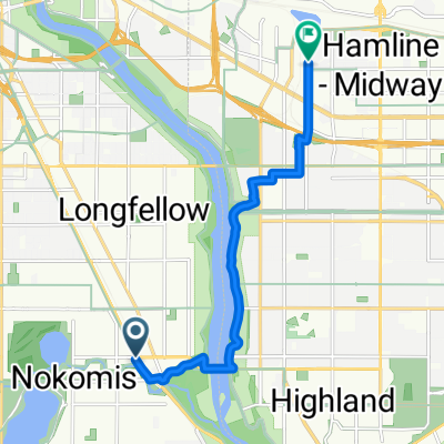
1. Allez vers le nord sur la 34e jusqu'à la 54e rue.
2. Tournez à droite sur la 54e rue et dirigez-vous vers l'est vers Minnehaha.
Prenez la piste cyclable de Minnehaha Ave vers le nord-ouest jusqu'à Lake Street.
Traversez Lake Street alors que Minnehaha Ave se transforme en 26th Ave S et continuez vers le nord jusqu'à 26th Street.
À ce stade, vous pouvez soit continuer sur la 26 jusqu'à Riverside et 26. La 26 est sûre, mais il n'y a pas de piste cyclable. L'itinéraire qui est mappé est sur plus de pistes cyclables, comme suit
Tournez à gauche sur la 26e rue et recherchez le chemin de la ligne de tramway (qui apparaît juste avant Hiawatha Ave).
Tournez à droite sur le chemin et suivez le chemin le long du tramway jusqu'à la station Cedar/Riverside.
7. Juste après la station Cedar/Riverside, tournez à droite sur la 15, puis vite à droite sur la 6.
8. Suivez la 6 jusqu'à la 20 et tournez à gauche.
9. Prenez la piste cyclable sur la 20 jusqu'à Riverside, puis tournez à droite.
10. Riverside a parfois beaucoup de trafic, donc vous pouvez soit pousser votre vélo sur le trottoir pendant les derniers blocs, soit choisir de rouler jusqu'à Fairview.
créé il y a 17 ans
Qualité de l’itinéraire
Route tranquille
7 km
(54 %)
Piste cyclable
1,9 km
(15 %)
Pavé
7,1 km
(55 %)
Asphalte
4,5 km
(35 %)
Pavé (non défini)
1,4 km
(11 %)
Continuer avec Bikemap
Tu veux parcourir B2B00377 55450 > 55454 via Minnehaha, LRT trail ou l’adapter à ton propre voyage ? Voici ce que tu peux faire avec cet itinéraire Bikemap :
Essai gratuit de 3 jours, ou paiement unique. En savoir plus sur Bikemap Premium.
Découvre plus de fonctionnalités Premium.
Obtiens Bikemap PremiumDe notre communauté
Ouvre-la dans l’app